Midday Nowcast: Lots of Sunshine Ahead of Midweek Storms
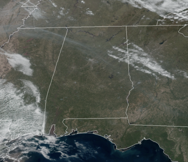
We are seeing lots of sunshine across the state today, and after the chill this morning, we are seeing temperatures approach the 70 degree mark this afternoon. More great weather tomorrow, and it will be warmer with highs surging into the 80s across the state as southerly flow increases tomorrow.
WARM, WINDY WEDNESDAY: Wednesday will be a warm, windy day with a high in the low to mid 80s as our next system approaches. In fact, non-thunderstorm winds during the day could gust to 40/45 mph at times before the storm arrives; a wind advisory will be needed Wednesday.
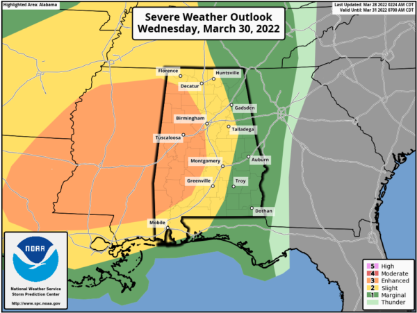
STRONG/SEVERE STORMS RETURN: A band of strong to severe thunderstorms will move into Alabama late in the day and continue to head east through the state Wednesday night. The SPC has all of Alabama under the threat for severe weather Wednesday night/Thursday morning. An “enhanced risk” (level 3/5) covers for much of West Alabama, for areas west of a line from Haleyville to Birmingham to Jackson. A “slight risk” (level 2/5) is for areas as far east as Huntsville, Montgomery, and Andalusia, and the eastern counties are in a “marginal risk” (level 1/5). Again, don’t focus at colors on the map, just know all of Alabama could see severe storms.
SETUP: This will be another system with very impressive wind fields and kinematic energy, but the thermodynamics aren’t impressive, limiting instability. This system looks to roll through Alabama as a QLCS (Quasi-Linear Convective System), what we use to call a squall line. Essentially a line of strong to severe storms will move through Alabama with the main concern being damaging winds, perhaps in excess of 70 mph in some of the stronger storms. Embedded within this line there could be some tornadoes as well. Hail is not much of a concern this week, as there will be some warmer air in the mid-levels.
TIMING: The line of severe storms will likely enter West Alabama late in the afternoon, 5-6PM, then sweep eastward Wednesday night. Storms could linger after midnight over the eastern counties, but they will be weakening at that time with the loss off daytime heating and the better dynamics pulling away. For areas of Central Alabama, Interstate 65 corridor, it looks to be in the 8PM-midnight timeframe.
HEAVY RAINFALL: Rain amounts of 1-2 inches are likely, and with the saturated soil conditions some isolated flooding problems could develop, but with the system moving through rapidly, widespread issues are not anticipated this go around.
BE PREPARED: Events like this are common in Alabama during March and April. Simply have multiple reliable ways of hearing severe weather warnings (NOAA Weather Radio, and emergency alerts on your phone), and a plan of action if you are “in the polygon”. In your safe place have helmets for everyone, and if you live in a mobile home, know the nearest shelter location, and how to get there quickly.
REST OF THE WEEK: Look for a clearing sky Thursday with a high around 70°. We expect the dry weather to continue on Friday with mostly sunny sky and highs again on either side of 70°
WEEKEND WEATHER: On Saturday, the Wednesday night front, will lift back north as a warm front, bringing clouds and rain back to the state, especially across the southern half of Alabama. No severe weather threat, but there could be some elevated thunderstorms producing lightning and thunder. By Sunday, dry weather returns to Alabama. Highs this weekend will range from the upper 60s to lower 70s.
NEXT WEEK: Dry weather continues Monday and Tuesday… global models suggest the next round of rain and storms will come Wednesday (April 6th).
BEACH FORECAST CENTER: Get the latest weather and rip current forecasts for the beaches from Fort Morgan to Panama City on our Beach Forecast Center page. There, you can select the forecast of the region that you are interested in visiting.
WORLD TEMPERATURE EXTREMES: Over the last 24 hours, the highest observation outside the U.S. was 111.2F at Nawabshah, Pakistan. The lowest observation was -83.4F at Concordia, Antarctica.
CONTIGUOUS TEMPERATURE EXTREMES: Over the last 24 hours, the highest observation was 102F at Rio Grande Village, TX. The lowest observation was -13F at Crane Lake, MN.
Category: Alabama's Weather, ALL POSTS
About the Author (Author Profile)
Macon, Georgia Television Chief Meteorologist, Birmingham native, and long time Contributor on AlabamaWX. Stormchaser. I did not choose Weather, it chose Me. College Football Fanatic. @Ryan_StinnetSubscribe
If you enjoyed this article, subscribe to receive more just like it.


