Midday Nowcast: Terrific Tuesday; Increasing Severe Weather Threat Wednesday Night
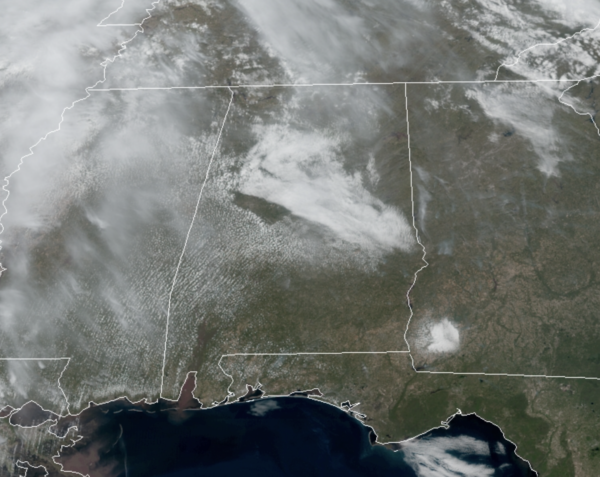
We are seeing a mix of sun and clouds across Alabama today, and we are seeing highs surging into the 80s across the state; overall a great spring day of weather.
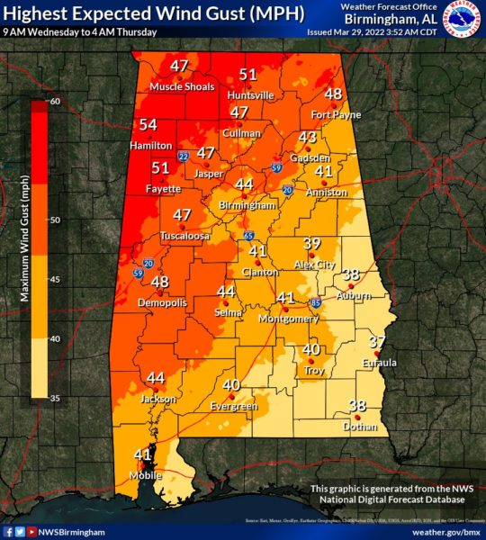
WARM, VERY WINDY WEDNESDAY: Tomorrow will be a very warm, windy day with a high in the mid to upper 80s as our next system approaches. In fact, non-thunderstorm winds during the day could gust to 40-50 mph at times before the storm arrives; a wind advisory has been issued for Wednesday for all of Alabama. This in itself will bring potential for some downed trees and power outages.
SEVERE STORMS RETURN: The SPC has all of Alabama under the threat for severe weather Wednesday night/Thursday morning. A “moderate risk” (level4/5) cover covers for much of West Alabama, for areas west of a line from Florence to Haleyville to Birmingham to Selma to Greenville, to Pensacola. An “enhanced risk” (level 3/5) covers pretty much the rest of the state. Again, don’t focus at colors on the map, just know all of Alabama is under a significant threat for severe storms.
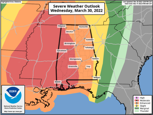
SETUP: This is a very dynamic system with very impressive wind fields and kinematic energy, but thankfully the thermodynamics aren’t impressive. However, this system has the potential to be a significant and impactful event for the state with widespread damaging winds. This system will roll through Alabama as a QLCS (Quasi-Linear Convective System), what we use to call a squall line. Essentially a line of severe storms will move through Alabama with the main concern being damaging winds, perhaps in excess of 80 mph in some of the stronger storms, especially in the “moderate risk” area across Mississippi and West Alabama. Embedded within this line there could be some tornadoes as well, and some of these tornadoes could be strong (EF2+). Hail is not much of a concern this week, as there will be some warmer air in the mid-levels.
TIMING: The line of severe storms will likely enter Northwest Alabama late in the afternoon, 5-6PM, then sweep eastward Wednesday night and into Thursday morning. For areas of Central Alabama, Interstate 59 corridor, it looks to be in the 8PM-12AM timeframe, then East and Southeast Alabama after midnight through 5AM Thursday.
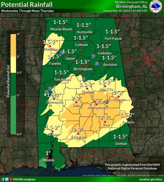
HEAVY RAINFALL: Rain amounts of 1-2 inches are likely, and with the saturated soil conditions some isolated flooding problems could develop, but with the system moving through rapidly, widespread issues are not anticipated this go around. Some locations across South Alabama, could receive as much as 3 inches.
CALL TO ACTION: Again, this has the potential to be a high impact wind event for much of Alabama; plan for power outages. Secure loose objects that might go flying away with strong winds. Pay close attention to severe thunderstorm warnings tomorrow night; if you live in a mobile home I would consider treating a severe thunderstorm warning like a tornado warning and be in a community shelter or business that is open and available as a shelter. Be sure you have multiple reliable ways of hearing warnings (NEVER a siren)… a NOAA Weather Radio and your phone; and be sure emergency alerts are enabled on your phone. Have the free ABC 33/40 weather app installed.
BE A HERO: You can help us. Tell your friends, neighbors, and relatives about the threat, and what they need to do to get ready. And, if they fall in a tornado or severe thunderstorm warning polygon, call them or text them to let them know about the threat. You are our most valuable resource in spreading the word!
Look for a clearing sky Thursday with a high around 70°.
FRIDAY AND THE WEEKEND: Look for mostly sunny days and fair nights Friday through Sunday. The high Friday will be in the upper 60s and mostly in the low 70s over the weekend. There will be a chance of showers near the Gulf Coast Saturday as a disturbance moves through the northern Gulf, but most of the state will be dry.
NEXT WEEK: Dry weather continues Monday, but global models suggest the next round of rain and storms will come Tuesday into Wednesday and it looks to possibly bring out next round of strong to severe storms, but way too early to be specific. Let’s get through tomorrow night before we worry about next week.
BEACH FORECAST CENTER: Get the latest weather and rip current forecasts for the beaches from Fort Morgan to Panama City on our Beach Forecast Center page. There, you can select the forecast of the region that you are interested in visiting.
WORLD TEMPERATURE EXTREMES: Over the last 24 hours, the highest observation outside the U.S. was 111.9F at Kayes, Mali. The lowest observation was -82.5F at Dome C, Antarctica.
CONTIGUOUS TEMPERATURE EXTREMES: Over the last 24 hours, the highest observation was 102F at Rio Grande Village, TX. The lowest observation was -12F at Mount Washington, NH.
Category: Alabama's Weather, ALL POSTS
About the Author (Author Profile)
Macon, Georgia Television Chief Meteorologist, Birmingham native, and long time Contributor on AlabamaWX. Stormchaser. I did not choose Weather, it chose Me. College Football Fanatic. @Ryan_StinnetSubscribe
If you enjoyed this article, subscribe to receive more just like it.


