CANCELED — SEVERE T-STORM WARNING: Parts of Dallas Co. Until 7 am
The National Weather Service in Birmingham has issued a
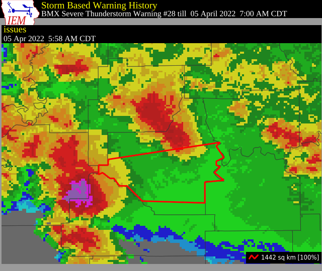
* Severe Thunderstorm Warning for…
Southern Dallas County in south central Alabama…
* Until 700 AM CDT.
* At 558 AM CDT, a severe thunderstorm was located near Consul, or 16
miles south of Uniontown, moving east at 45 mph.
HAZARD…Two inch hail and 60 mph wind gusts.
SOURCE…Radar indicated.
IMPACT…People and animals outdoors will be injured. Expect hail
damage to roofs, siding, windows, and vehicles. Expect
wind damage to roofs, siding, and trees.
* Locations impacted include…
Selma, Selmont-West Selmont, Orrville, Belknap, Tyler, Central
Mills, Dallas Lake, Old Cahaba Park, Dannelly Reservoir, Dallas
County Horse Arena, Skyharbor Airport, Whites Bluff, Safford,
Hazen, Craig Field Aiport, Selma Drag Strip and Crumptonia.
PRECAUTIONARY/PREPAREDNESS ACTIONS…
For your protection move to an interior room on the lowest floor of a
building.
Large hail and damaging winds and continuous cloud to ground
lightning is occurring with this storm. Move indoors immediately.
Lightning is one of nature’s leading killers. Remember, if you can
hear thunder, you are close enough to be struck by lightning.
Category: Alabama's Weather, ALL POSTS, Severe Weather
About the Author (Author Profile)
Scott Martin is an operational meteorologist, professional graphic artist, musician, husband, and father. Not only is Scott a member of the National Weather Association, but he is also the Central Alabama Chapter of the NWA president. Scott is also the co-founder of Racecast Weather, which provides forecasts for many racing series across the USA. He also supplies forecasts for the BassMaster Elite Series events including the BassMaster Classic.Subscribe
If you enjoyed this article, subscribe to receive more just like it.


