Mesoscale Discussion — Severe Threat Continues Across Much of Central Alabama
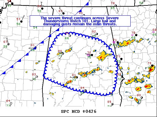
SUMMARY… The severe threat continues across Severe Thunderstorm Watch 101. Large hail and damaging gusts remain the primary concern.
DISCUSSION… Multicellular/brief, transient supercellular storms continue to progress across Severe Thunderstorm Watch 101 amid an unstable, but modestly sheared warm sector. Sub-severe hail has been reported with a few of the storms. However, the 18Z BMX observed sounding depicted 8.5 C/km mid-level lapse rates atop 70F surface dewpoints, suggesting that ample cooling aloft and associated buoyancy is sufficient for severe hail production for any storm that can mature. In addition to the severe threat associated with the ongoing warm-sector cells, additional storm development is possible immediately along the cold front. A slight increase in deep-layer shear may occur in tandem with the cold front approaching, and this may sustain the severe threat into the late afternoon to early evening hours.
Category: Alabama's Weather, ALL POSTS, Severe Weather
About the Author (Author Profile)
Scott Martin is an operational meteorologist, professional graphic artist, musician, husband, and father. Not only is Scott a member of the National Weather Association, but he is also the Central Alabama Chapter of the NWA president. Scott is also the co-founder of Racecast Weather, which provides forecasts for many racing series across the USA. He also supplies forecasts for the BassMaster Elite Series events including the BassMaster Classic.Subscribe
If you enjoyed this article, subscribe to receive more just like it.


