Sunday Weather Xtreme: Great Day for a Race
Saturday was an absolutely beautiful day across Central Alabama. With a good supply of sunshine, high temperatures climbed into the lower and middle 80s. A nice southerly breeze at times kept it from feeling too hot. The overnight hours were calm and mild with lows near 60F.
FOR YOUR SUNDAY: Great weather for today’s running of the GEICO 500 at Talladega, as well as any other events across Central Alabama, including the USFL game today at 3 p.m. at Protective Stadium between the Breakers and Bandits. If you haven’t been yet, it is a blast. Highs this afternoon will peak in the lower to middle 80s.
THE WORK WEEK: The storm system that produced severe weather in Oklahoma yesterday will move out of the Plains on Monday, but will be weakening. It will slide to the north of Alabama on Tuesday, dragging a front and some rain and storms into the area. Monday will feature a good supply of sunshine and warm temperatures again. We will see increasing clouds Monday night with showers moving into Northwest Alabama. The rain will reach the I-59 corridor during the late-night and morning hours Monday night and Tuesday. Highs Tuesday will be lower, in the lower 70s. The cooler trend will continue into Wednesday behind the cool front. But readings near and above 80F will return by Thursday into the weekend. WHAT ABOUT THE
WEEKEND: Some areas will push into the upper 80s by Sunday. Skies will be partly to mostly sunny. We will be watching for our next weather maker in the form of a stronger trough pushing by to the north of us late Sunday into Monday. This means another round of rain and thunderstorms.
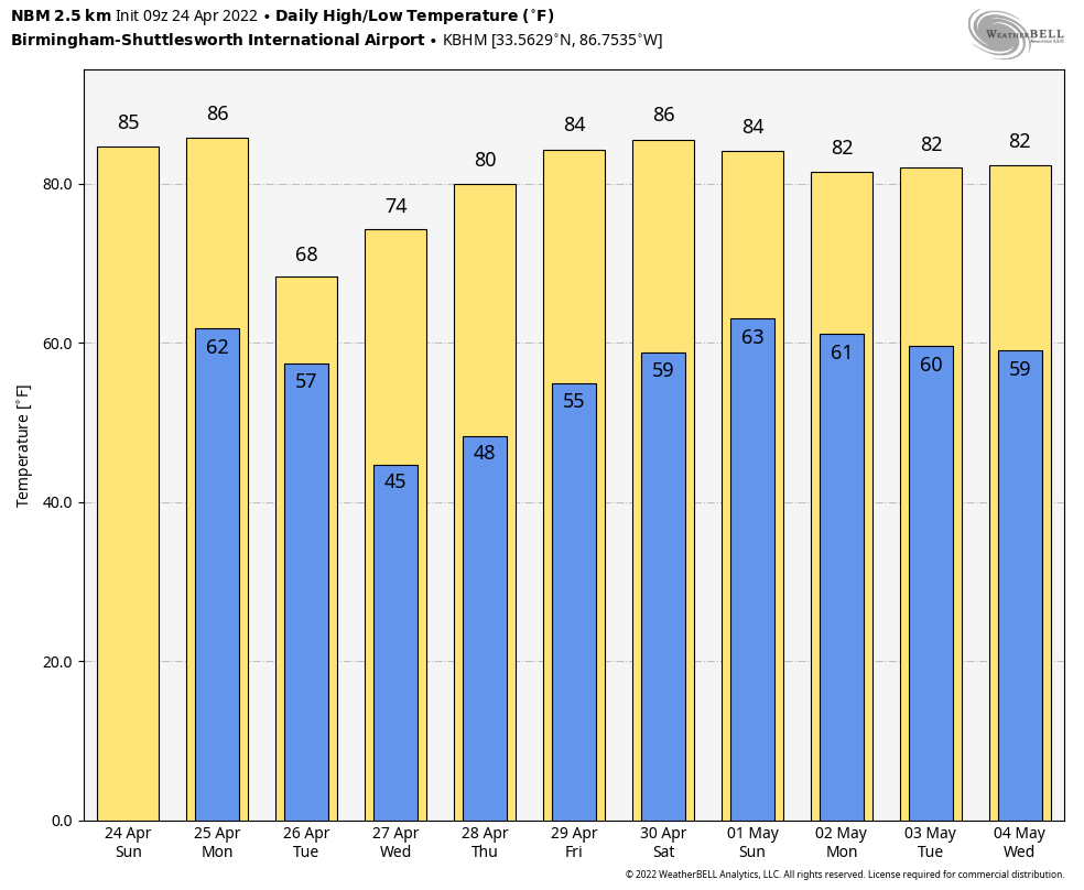
VOODOO TERRITORY: It looks like an upper-level low will drop into the area late in the following week with more rain and storms.
BEACHCAST: Really nice time to be at the beach this week as warm and mostly dry weather will be the rule. A few showers will appear Tuesday afternoon and night, but it won’t be a washout. Water temperatures are coming up, near 70 degrees now, but the rip current will be dangerous through at least Monday night as strong southerly and southeasterly winds blow persistently onshore.
Click here to see the Beach Forecast Center page.
DANCING WITH THE STATS: 25F in Alta UT yesterday morning. Ely NV picked up a record 4.2 inches of snow.
ADVERTISE WITH US: Deliver your message to a highly engaged audience by advertising on the AlabamaWX.com website. The site enjoyed over 29 MILLION page views in the past 12 months. Don’t miss out! We can customize a creative, flexible, and affordable package that will suit your organization’s needs. Contact me, Bill Murray, at (205) 687-0782 and let’s talk.
WEATHERBRAINS: This week, the panel will continue its looks at tornado emergencies and the latest in the tornado warning process. We will be joined by fan-favorite and local WCM at the NWS Birmingham, Kevin Laws. Dr. Stephen Beida will join us as well. He is the tallest hog in the trough as James says when it comes to the NWS Alerting Initiative. Check out the show at www.WeatherBrains.com. You can also subscribe on iTunes. You can watch the show live at live.bigbrainsmedia.com or on James’ YouTube Channel You will be able to see the show on the James Spann 24×7 weather channel on cable or directly over the air on the dot 2 feed.
ON THIS DATE IN 1999: 113 mph wind gust at Brigham City, UT, established the state record for highest low-elevation wind. Follow my weather history tweets on Twitter. I am @wxhistorian at Twitter.com.
Category: Alabama's Weather, ALL POSTS
About the Author (Author Profile)
Bill Murray is the President of The Weather Factory. He is the site's official weather historian and a weekend forecaster. He also anchors the site's severe weather coverage. Bill Murray is the proud holder of National Weather Association Digital Seal #0001 @wxhistorianSubscribe
If you enjoyed this article, subscribe to receive more just like it.


