

Midday Nowcast: Watching Storms on the Radar
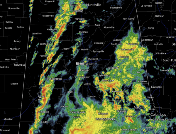
WATCHING THE RADAR: The cold front is working into West Alabama currently and out ahead of it, we are seeing showers and storms developing and tracking east. We are keeping an eye on these as they are producing heavy rainfall and frequent lightning, but also there remains a risk of severe storms as we roll into the afternoon hours.
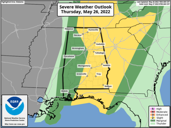
The SPC has a lot of the state in a “slight risk” (level 2/5) of severe thunderstorms today, while the rest of it is in a “marginal risk” (level 1/5).
The stronger storms will be capable of producing hail and gusty winds. There is a very low end risk of an isolated, brief tornado, and we may even see some sort of watch issued across portions of the area. Additional rain amounts of around one inch are likely for most places. The rain and storms will end from west to east as the cold front moves through the state later this afternoon and evening.
FINE FRIDAY: Dry air will work into the state late tonight, and tomorrow will be a mostly sunny day with a in the upper 70s. It will be less humid, making it feel very nice for late May.
MARVELOUS MEMORIAL DAY WEEKEND: The weather will be delightful for the three day holiday weekend with sunny days, fair nights, and highs in the 80s. Nights will be refreshing with widespread 50s possible. Monday should be the hottest of the weekend with highs close to 90°.
REST OF NEXT WEEK: An upper ridge will build across the Gulf Coast region, meaning mostly hot and dry weather with highs in the low 90s. It still looks like a few scattered showers begin to pop back up across the state by midweek as those humidity levels climb slowly.
BEACH FORECAST CENTER: Get the latest weather and rip current forecasts for the beaches from Fort Morgan to Panama City on our Beach Forecast Center page. There, you can select the forecast of the region that you are interested in visiting.
WORLD TEMPERATURE EXTREMES: Over the last 24 hours, the highest observation outside the U.S. was 117.3F at Suwaiq, Oman. The lowest observation was -98.9F at Vostok, Antarctica.
CONTIGUOUS TEMPERATURE EXTREMES: Over the last 24 hours, the highest observation was 112F at Death Valley, CA. The lowest observation was 17F at Toponas, CO.
Category: Alabama's Weather, ALL POSTS
About the Author (Author Profile)
Macon, Georgia Television Chief Meteorologist, Birmingham native, and long time Contributor on AlabamaWX. Stormchaser. I did not choose Weather, it chose Me. College Football Fanatic. @Ryan_StinnetSubscribe
If you enjoyed this article, subscribe to receive more just like it.


