Midday Nowcast: Welcome to June
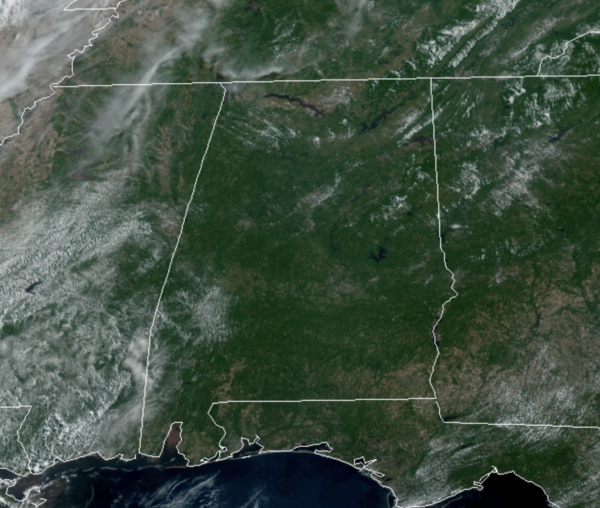
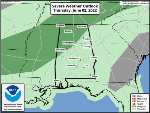
Welcome to the new month, and the forecast for today is pretty routine early June weather. We are seeing more sun than clouds with temperatures heading towards the low 90s for much of North/Central Alabama. A few pop-up afternoon showers and storms are possible, but rain chances are generally less than 20%. For tomorrow, as a surface front will drop into the state, bringing a higher coverage of showers and storms tomorrow afternoon and tomorrow night. It won’t rain everywhere, but the chance of any one spot seeing a shower or thunderstorm is 50-60 percent, and some of the storms could be strong. The SPC maintains a “marginal risk” (level 1/5) of severe thunderstorms for areas along and north of I-59, where some hail and strong winds are possible.
ACROSS THE USA: Isolated to scattered severe thunderstorms and heavy rainfall is expected to produce strong winds, large hail and flooding in portions of the Southern Plains into the Ozarks and gusty winds and isolated large hail in the Ohio Valley into the Northeast on Tuesday.
IN THE TROPICS: Today is the first official day of the Atlantic hurricane season that runs through Novermber 30th. Two areas the NHC is monitoring today. A large area of disorganized showers and thunderstorms located over the northwestern Caribbean Sea and Yucatan Peninsula is associated with a broad area of low pressure; these are the remnants of Agatha. Environmental conditions appear conducive for gradual development, and this system is likely to become a tropical depression while it moves northeastward over the northwestern Caribbean Sea and southeastern Gulf of Mexico during the next couple of days. Regardless of development, locally heavy rainfall is likely across portions of southeastern Mexico, the Yucatan Peninsula, and Belize during the next day or so, spreading across western Cuba, South Florida, and the Florida Keys on Friday and Saturday. Interests in the Yucatan Peninsula, western Cuba, the Florida Keys, and the Florida Peninsula should monitor the progress of this system. Formation chance through 5 days…high…80 percent. Again, this is likely to become Alex.
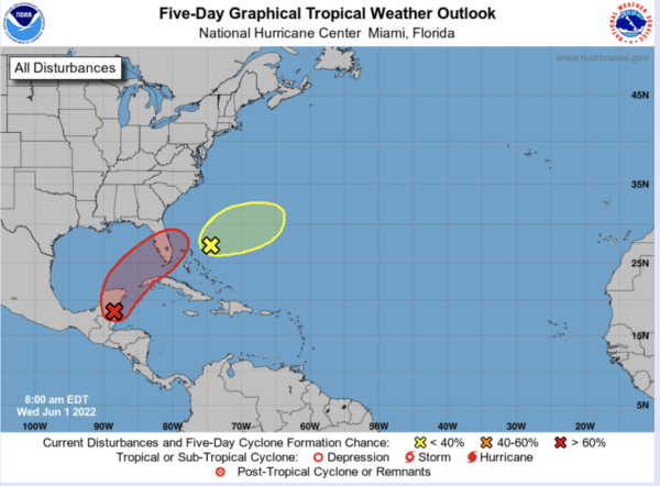
In the Southwestern Atlantic northeast of the Bahamas: A weak surface trough located around 200 miles northeast of the central Bahamas is producing disorganized shower activity as it interacts with an upper-level trough. Surface pressures are currently high across the area, and significant development of this system appears unlikely as it moves generally east-northeastward over the next several days away from the southeastern United States. Formation chance through 5 days…low…10 percent.
Next name up would be Bonnie.
FRIDAY AND THE WEEKEND: Behind the front, a surge of drier air enters the state and will bring rain-free weather to Alabama Friday and Saturday. The weather will be very pleasant, with highs in the low to mid 80s and lower humidity. Many places will drop into the 50s early Saturday morning with a clear sky. Sunday, temperatures will be closer to 90° and a pop-up shower and storm will return to the forecast.
NEXT WEEK: We are looking at a pretty routine week for early June; partly sunny days, fair nights, and the chance of “scattered, mostly afternoon and evening showers and thunderstorms” on most days. Highs will stay close to the 90 degree mark.
BEACH FORECAST CENTER: Get the latest weather and rip current forecasts for the beaches from Fort Morgan to Panama City on our Beach Forecast Center page. There, you can select the forecast of the region that you are interested in visiting.
WORLD TEMPERATURE EXTREMES: Over the last 24 hours, the highest observation outside the U.S. was 116.6F at Jacobabad, Pakistan. The lowest observation was -90.9F at Dome C, Antarctica.
CONTIGUOUS TEMPERATURE EXTREMES: Over the last 24 hours, the highest observation was 113F at Rio Grande Village, TX. The lowest observation was 14F at Kamas, UT.
Category: Alabama's Weather, ALL POSTS
About the Author (Author Profile)
Macon, Georgia Television Chief Meteorologist, Birmingham native, and long time Contributor on AlabamaWX. Stormchaser. I did not choose Weather, it chose Me. College Football Fanatic. @Ryan_StinnetSubscribe
If you enjoyed this article, subscribe to receive more just like it.


