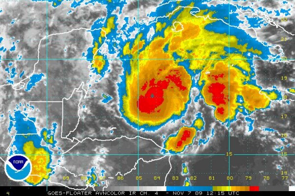
Tropical Storm Ida Moving Northward
FAST FACTS ON IDA
6:00 AM CST Sat Nov 7
Location: 17.4°N 84.1°W or 330 miles southeast of the NE Tip of Yucatan
Max sustained: 45 mph
Moving: N at 8 mph
Min pressure: 1002 mb
WARNINGS: Tropical Storm Watches issued for parts of Yucatan and Western Cuba

Ida looks much better on satellite this morning. It is over warm water. It is in an area of slightly elevated shear, however, and wind shear will be increasing as it heads along its track.
Tropical storm force winds will reach the northeastern Yucatan by noon Sunday and the storm will threat the needle of the Yucatan Channel between Mexico and Cuba Sunday afternoon.
Then we will have a strong tropical storm (60 mph) in the southern Gulf.
The good news is that building high pressure over the northern Gulf Coast will like repel the storm southeastward and perhaps even southward back into the Gulf where it could dissipate as it merges with a frontal system.
The bad news is that we can’t predict with certainty when that southward turn might occur. Last night’s runs of the GFS get it pretty close to the northern Gulf Coast before turning it. The overnight run of the GFDL gets it to a point only 180 miles south of Destin and 150 miles south of Panama City before turning it back.
Fortunately, it will be over cooler water and undergoing quite a bit of shear as it goes further over the Gulf, which means it will not be very strong. But heavy rains will be a problem to the north of the storm. South Alabama is likely to get heavy rain Tuesday and Wednesday. A more northerly path would mean Central Alabama would see heavy rain as well.
Strong winds are going to be a problem over the northern Gulf Coast in any case because of a strong pressure gradient that will develop between high pressure to the north and Ida to the south. I think we will definitely see tropical storm force winds along the coast, with the potential for some hurricane force gusts if the storm draws to within 200 miles of the coast.
Ida will definitely be interesting to watch over the next week.
Category: Uncategorized


Comments (1)
Trackback URL | Comments RSS Feed
Sites That Link to this Post