Midday Nowcast: Still Hot, Some Late Day Strong Storms
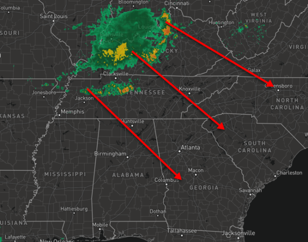
The heat advisory continues today for all of Alabama as heat index values continue to be in the 105°-110° range this afternoon. Some pop-up storms are possible this afternoon, but the main storm threat comes later today as a complex of storms rolls out of the Tennessee Valley.
These are associated with a front that will bring drier air into Alabama for the weekend.
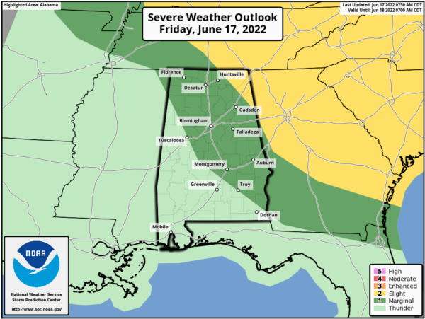
The SPC has most of North and Central Alabama in a “marginal risk” (level 1/5) of severe thunderstorms this afternoon and evening. As we have seen all week, stronger storms will produce strong winds and some small hail. Of course, expect lots of lightning and window shaking thunder with any storms today.
Until those storms arrive, we are seeing a mix of sun and clouds with temperatures in the mid to upper 90s again. The bulk of these storms will stay east of Alabama, but some of these will impact portions of Alabama, but not everyone will see rain today. Just pay attention to radar trends later today. ?
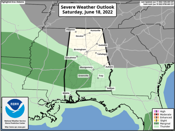
WEEKEND WEATHER: As the front sinks southwest through the state, the drier air mass moves into the state, and we will get a break from the Heat Advisory for much of Alabama, but we do note portions of West and Central Alabama will remain under an advisory tomorrow. Some storms are likely to develop ahead of the boundary, and portions of Southwest Alabama have been included in a risk of severe storms tomorrow.
By late tomorrow, the front will push south to the Gulf Coast, finally giving all of Alabama from the oppressive humidity. For North/Central Alabama tomorrow expect sunshine and highs in the low 90s. Sunday morning, we project lows in the upper 50s and low 60s due to the dry air. Sunday will be a sunny day statewide with a high generally in the low to mid 90s.
NEXT WEEK: The upper ridge strengthens and temperatures will increase…Highs much of next week will be in the mid to upper 90s and low 100s. Next week looks to be hotter than this week, as far as temperatures, but humidity levels may be a bit lower. Rain chances look to be generally less than 10% each day with only isolated afternoon and evening storms possible.
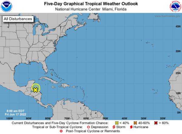
IN THE TROPICS: All remains quiet for now. Still watching disorganized showers and thunderstorms located over the northwestern Caribbean Sea are associated with a trough of low pressure. Some slow development of this system is possible before it moves inland over northern Central America and the Yucatan Peninsula tonight or on Saturday. Regardless of development, locally heavy rainfall is possible over Honduras, Belize, northern Guatemala, and southeastern Mexico through the weekend. Formation chance through 5 days…low…10 percent.
BEACH FORECAST CENTER: Get the latest weather and rip current forecasts for the beaches from Fort Morgan to Panama City on our Beach Forecast Center page. There, you can select the forecast of the region that you are interested in visiting.
WORLD TEMPERATURE EXTREMES: Over the last 24 hours, the highest observation outside the U.S. was 119.5F at Fahud, Oman. The lowest observation was -77.8F at Amundsen-Scott South Pole Station, Antarctica.
CONTIGUOUS TEMPERATURE EXTREMES: Over the last 24 hours, the highest observation was 117F at Death Valley, CA. The lowest observation was 20F at Peter Sinks, UT.
Category: Alabama's Weather, ALL POSTS
About the Author (Author Profile)
Macon, Georgia Television Chief Meteorologist, Birmingham native, and long time Contributor on AlabamaWX. Stormchaser. I did not choose Weather, it chose Me. College Football Fanatic. @Ryan_StinnetSubscribe
If you enjoyed this article, subscribe to receive more just like it.


