We Now Have PTC-2 Out in the Tropical Atlantic Ocean
DISTURBANCE APPROACHING THE SOUTHERN WINDWARD ISLANDS… TROPICAL STORM WARNINGS ISSUED.
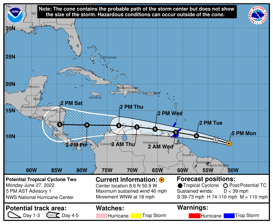
SUMMARY OF 500 PM AST…2100 UTC…INFORMATION
———————————————-
LOCATION…8.6N 50.9W
ABOUT 720 MI…1155 KM E OF TRINIDAD
MAXIMUM SUSTAINED WINDS…40 MPH…65 KM/H
PRESENT MOVEMENT…WNW OR 285 DEGREES AT 18 MPH…30 KM/H
MINIMUM CENTRAL PRESSURE…1009 MB…29.80 INCHES
WATCHES AND WARNINGS
——————–
SUMMARY OF WATCHES AND WARNINGS IN EFFECT:
A Tropical Storm Warning is in effect for…
* Trinidad and Tobago
* Grenada and its dependencies
A Tropical Storm Warning means that tropical storm conditions are expected somewhere within the warning area within 36 hours.
Interests elsewhere in the Windward Islands, the northern coast of Venezuela, and the ABC Islands should monitor the progress of this system.
For storm information specific to your area, please monitor products issued by your national meteorological service.
DISCUSSION AND OUTLOOK
———————-
At 500 PM AST (2100 UTC), the disturbance was centered near latitude 8.6 North, longitude 50.9 West. The system is moving toward the west-northwest near 18 mph (30 km/h), and this general motion is expected to continue for the next few days. On the forecast track, the system will pass near or over portions of the southern Windward Island by late Tuesday, and move over the southern Caribbean Sea or near the northern coast of Venezuela on Wednesday and Thursday.
Maximum sustained winds are near 40 mph (65 km/h) with higher gusts. Some strengthening is forecast during the next 48 hours.
Conditions appear conducive for development, and the disturbance will likely become a tropical storm before reaching the southern Windward Islands.
* Formation chance through 48 hours…high…70 percent.
* Formation chance through 5 days…high…90 percent.
Tropical-storm-force winds extend outward up to 60 miles (95 km) north of the center.
The estimated minimum central pressure is 1009 mb (29.80 inches).
HAZARDS AFFECTING LAND
———————-
RAINFALL: The Potential Tropical Cyclone is expected to produce heavy rain across the southern Windward Islands and the northeastern coast of Venezuela starting Tuesday night into Wednesday. The following storm total rainfall amounts are expected:
Islands from Guadeloupe to St. Lucia: 1 to 3 inches.
St. Vincent, the Grenadines, and Barbados: 3 to 4 inches.
Grenada, Trinidad and Tobago, and northeastern Venezuela: 4 to 6 inches.
WIND: Tropical storm conditions are expected in the warning area by late Tuesday.
About the Author (Author Profile)
Scott Martin is an operational meteorologist, professional graphic artist, musician, husband, and father. Not only is Scott a member of the National Weather Association, but he is also the Central Alabama Chapter of the NWA president. Scott is also the co-founder of Racecast Weather, which provides forecasts for many racing series across the USA. He also supplies forecasts for the BassMaster Elite Series events including the BassMaster Classic.Subscribe
If you enjoyed this article, subscribe to receive more just like it.


