Scattered Storms Daily This Week; Highs Mostly In The Upper 80s
RADAR CHECK: A number of summer soakers are in progress across Alabama this afternoon… heaviest rain is generally south of I-20. Understand it isn’t raining everywhere… that is just the way it works here this time of the year. Summer thunderstorms are random and scattered, but the stronger storms this afternoon are producing torrential rain, strong gusty winds, small hail, and lots of lightning. Where rain is falling, temperatures are in the 70s… away from the showers readings are mostly between 84 and 90 degrees.
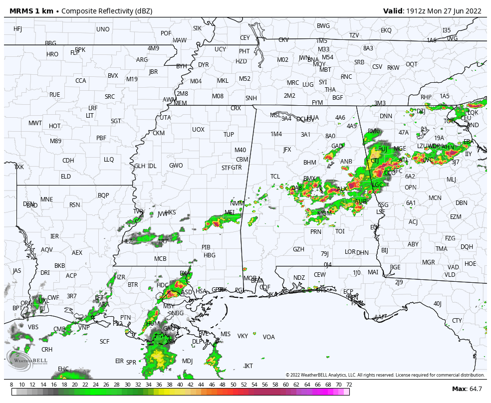
Showers and storms will fade after sunset; the low tonight will be close to 70 degrees.
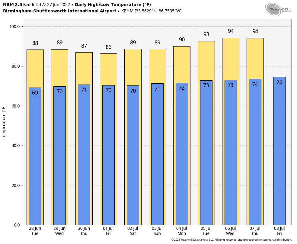
REST OF THE WEEK: The weather won’t change much tomorrow through Friday. The heat dome has shifted to the west, and a surface front becomes stationary over North Alabama. This means a mix of sun and clouds each day with showers and storms around, mostly from about 2:00 until 10:00 p.m. Odds of any one spot seeing rain each day is 35-45 percent, and highs will be mostly in the upper 80s. Pretty much what you expect in late June in Alabama.
FOURTH OF JULY WEEKEND: We don’t see any real change for the weekend. Partly sunny, warm, humid days with random, scattered storms around mostly during the afternoon and evening hours. No way of knowing in advance exactly when and where the storms pop up; you just have to watch radar trends if you have an outdoor event planned. And, remember, when thunder roars, get indoors! Highs will remain in the 86-90 degree range Saturday through Monday.
REST OF NEXT WEEK: The upper ridge tries to rebuild… afternoon highs will be mostly in the low 90s through the week with hazy days and widely scattered afternoon showers and storms. See the daily Weather Briefing video for maps, graphics, and more details.
TROPICS: Disorganized showers and thunderstorms over the north-central Gulf of Mexico are associated with a trough of low pressure. Development of this system is expected to be slow to occur while it moves west-southwestward at about 10 mph toward the northwestern Gulf of Mexico and approaches the coasts of southern Texas and northeastern Mexico during the next few days. NHC gives this only a 20 percent chance of development, and it will not directly impact the Central Gulf Coast (Gulf Shores to Panama City Beach).
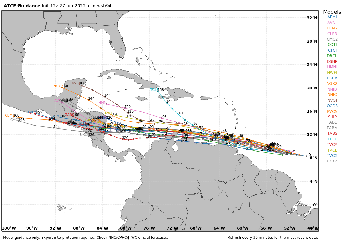
In the Atlantic, a tropical wave located about 700 miles east-southeast of the southern Windward Islands is producing a large area of showers and thunderstorms. Environmental conditions appear conducive for development, and a tropical depression or a tropical storm is likely to form during the next day or so before the system reaches the Windward Islands tomorrow night or possibly while moving westward across the southern Caribbean Sea Wednesday through Friday. A NOAA Hurricane Hunter aircraft is currently investigating the system and has found winds to tropical storm force. Interests in the Windward Islands and along the northeastern coast of Venezuela should monitor the progress of this system, and tropical storm watches or warnings could be required for portions of these areas later today. Regardless of development, locally heavy rainfall is possible over the Windward Islands and the northeastern coast of Venezuela tomorrow night and Wednesday.
NHC gives the system a 90 percent chance of development; it will likely move into Central America in 5-7 days, staying far south of the U.S.
ON THIS DATE IN 1957: Hurricane Audrey made landfall between Sabine Pass and Johnsons Bayou, Louisiana around 7 AM CST June 27, 1957 as a strong category three hurricane with maximum sustained winds of 125 mph and a minimum central pressure of 27.94″. Just about everyone who lives in or grew up across Southern Louisiana and Southeast Texas knows the story of Hurricane Audrey, whether it was stories their parents or grandparents passed on, or literature they read within the history books.
Hurricane Audrey ranks as the 7th deadliest hurricane to strike the United States (3rd deadliest within Louisiana) in modern record keeping, with at least 500 deaths. The exact number will never be known, as many perished in the storm surge in Cameron and Vermilion parishes, and many missing persons were never found. Hurricane Audrey is also noted as being one of the strongest June hurricanes, and earliest major hurricane to make landfall across Louisiana, as well as the United States.
BEACH FORECAST: Click here to see the AlabamaWx Beach Forecast Center page.
Look for the next Weather Briefing video here by 6:00 a.m tomorrow…
Category: Alabama's Weather, ALL POSTS, Weather Xtreme Videos
About the Author (Author Profile)
James Spann is one of the most recognized and trusted television meteorologists in the industry. He holds the AMS CCM designation and television seals from the AMS and NWA. He is a past winner of the Broadcast Meteorologist of the Year from both professional organizations.Subscribe
If you enjoyed this article, subscribe to receive more just like it.


