Midday Nowcast: Warm, Muggy, Scattered Afternoon Storms
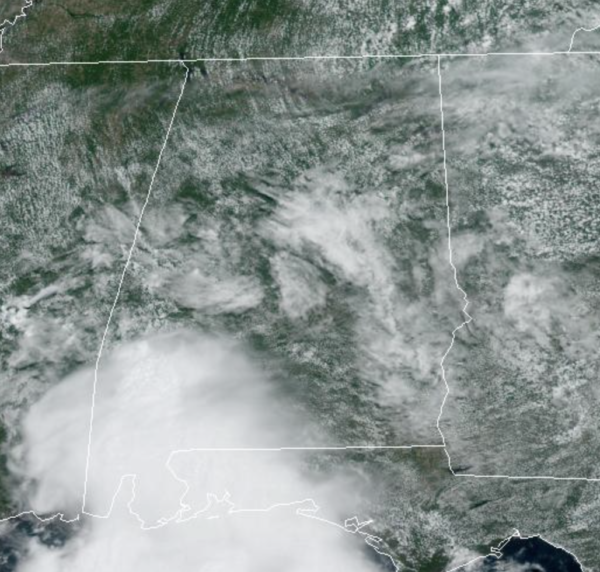
Another very warm and muggy day with temperatures ranging from the mid 80s to lower 90s. We are seeing a mix of sun and clouds, and watching the radar for those daily, random showers and storms to develop across the Alabama landscape. We are seeing rain and storms across Southwest Alabama at the midday hours, but through the afternoon hours, rain and storms will increase in coverage across Central and North Alabama.
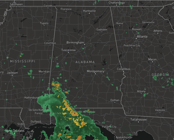
As we see each day, summer storms can pack a punch with tremendous amounts of lightning. Also, they can produce tropical downpours which can lead to areas of isolated flash flooding, plus it is not entirely out of the question to have a few severe storms along the way this week, with gusty winds the main threat. This time of year, it is almost impossible to know exactly when and where storms will occur, you just have to watch radar trends through the day. Expect the same tomorrow.
FOURTH OF JULY WEEKEND: The weather won’t change much over the long holiday weekend. You will see some sun at times Saturday, Sunday, and Monday, but from time to time a passing shower or storm is likely, especially during the afternoon and evening hours. Highs will be mostly in the upper 80s. Again, be prepared to dodge raindrops along the way, but it will be no “weekend washout”
REST OF NEXT WEEK: The upper ridge will remain mostly west of Alabama, but we can expect afternoon highs to return to the low 90s by the middle of the week. Expect partly sunny days, with scattered, mainly afternoon and evening storms.
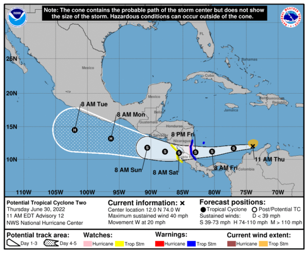
STILL WAITING ON BONNIE: Potential Tropical Cyclone Two was centered near latitude 12.0 North, longitude 74.0 West. The system is moving toward the west near 20 mph, and a continued mostly westward motion with a decrease in forward speed is expected through Saturday. On the forecast track, the system will move across the southwestern Caribbean Sea today through Friday, cross southern Nicaragua or northern Costa Rica Friday night, and emerge over the eastern Pacific Ocean on Saturday.
Maximum sustained winds are near 40 mph with higher gusts. Some strengthening is forecast through Friday while the system approaches Central America. Weakening is expected while the system crosses Central America, but restrengthening is forecast on Saturday once it moves over the Pacific Ocean. Conditions appear conducive for development, and the disturbance is expected become a tropical storm while slowing down over the southwestern Caribbean Sea. Formation chance through 48 hours… high…90 percent.Tropical-storm-force winds extend outward up to 80 miles from the center. The estimated minimum central pressure is 1008 mb (29.77 inches). We note, when the system crosses into the Pacific Ocean after landfall in Central America, it will get a new name…likely Darby.
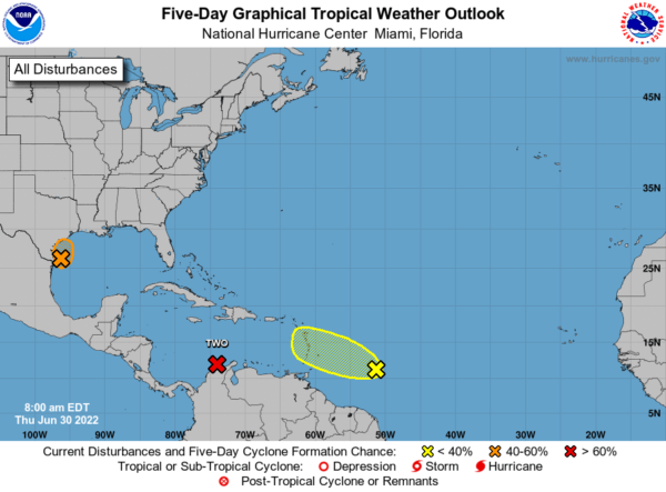
ELSEWHERE IN THE TROPICS: Recent satellite and radar imagery indicate that showers and thunderstorms associated with an area of low pressure near the southern coast of Texas are showing limited signs of organization. The disturbance is forecast to turn northward and move slowly inland over southeastern Texas later today. Slow development of this system is possible while the low remains over water and it could still become a short-lived tropical depression before it moves inland. Regardless of development, heavy rain will be possible along portions of the Texas coast for the next two days. For more information about the potential for heavy rain, please see products issued by your National Weather Service office. An Air Force Reserve Hurricane Hunter plane is scheduled to investigate the disturbance this afternoon, if it remains over water. Formation chance through 5 days…medium…40 percent.
Also, a tropical wave located several hundred miles east of the Windward Islands is producing disorganized showers and thunderstorms. Any development of this system should be slow to occur while the wave moves west-northwestward during the next day or two. The wave is forecast to move over the Windward Islands on Friday and then over the eastern Caribbean Sea by the weekend, where further development is unlikely due to unfavorable environmental conditions. Formation chance through 5 days…low…10 percent.
The next two names up are Colin and Danielle.
BEACH FORECAST CENTER: Get the latest weather and rip current forecasts for the beaches from Fort Morgan to Panama City on our Beach Forecast Center page. There, you can select the forecast of the region that you are interested in visiting.
WORLD TEMPERATURE EXTREMES: Over the last 24 hours, the highest observation outside the U.S. was 120.4F at Safi-Abad Dezful, Iran. The lowest observation was -99.8F at Concordia, Antarctica.
CONTIGUOUS TEMPERATURE EXTREMES: Over the last 24 hours, the highest observation was 119F at Death Valley, CA. The lowest observation was 26F at Mackay, ID.
Category: Alabama's Weather, ALL POSTS
About the Author (Author Profile)
Macon, Georgia Television Chief Meteorologist, Birmingham native, and long time Contributor on AlabamaWX. Stormchaser. I did not choose Weather, it chose Me. College Football Fanatic. @Ryan_StinnetSubscribe
If you enjoyed this article, subscribe to receive more just like it.


