Severe Thunderstorm Watch Issued Until 10 pm for Much of Central Alabama
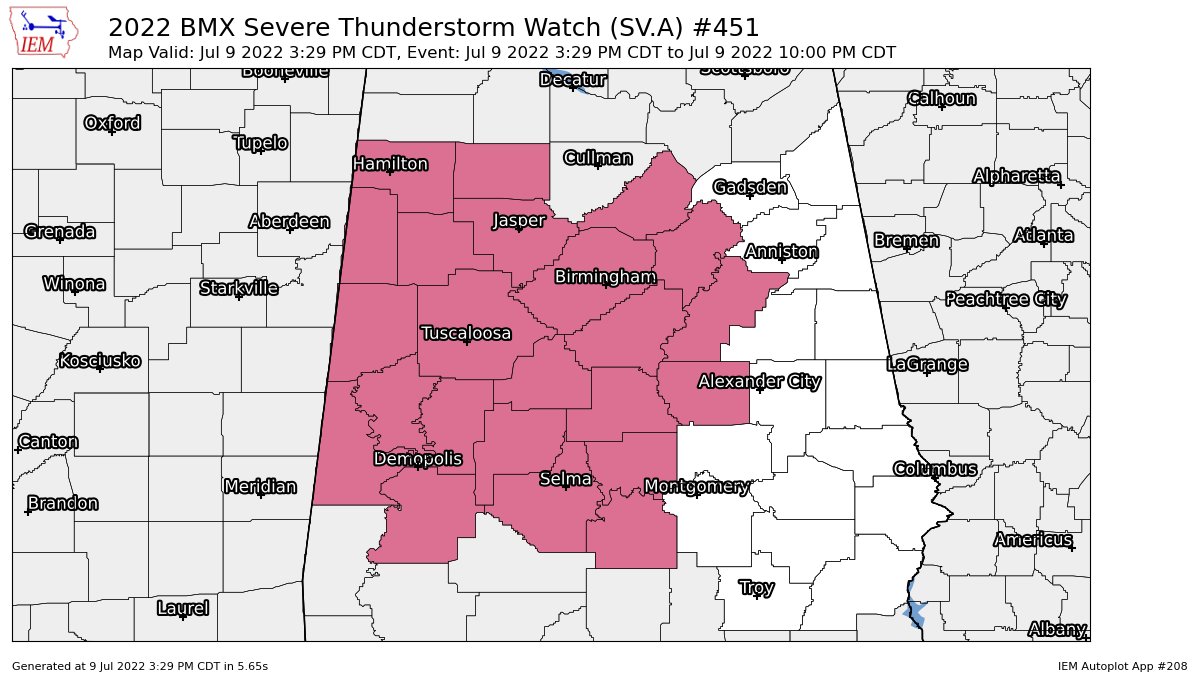
The Storm Prediction Center and NWS Birmingham has issued a Severe Thunderstorm Watch effective immediately and is set to expire tonight at 10 pm for the following counties in Central Alabama:
Autauga, Bibb, Blount, Chilton, Coosa, Dallas, Fayette, Greene, Hale, Jefferson, Lamar, Lowndes, Marengo, Marion, Perry, Pickens, Shelby, St. Clair, Sumter, Talladega, Tuscaloosa, Walker, Winston.
• Scattered wind gusts up to 70 mph possible
• Isolated hail up to 1/2-inch in diameter possible
• Frequent cloud-to-ground lightning possible.
Text from the SPC:
The NWS Storm Prediction Center has issued a
* Severe Thunderstorm Watch for portions of
Central and west central Alabama
Southeastern Arkansas
Extreme northeastern Louisiana
Central and northern Mississippi
* Effective this Saturday afternoon and evening from 330 PM until
1000 PM CDT.
* Primary threats include…
Scattered damaging wind gusts to 70 mph possible
SUMMARY…Scattered thunderstorms are developing ahead of a cold
front from southern Arkansas eastward across northern Mississippi
into Alabama. The storms could grow into a few clusters or loosely
organized lines, with the potential to produce occasional damaging
outflow gusts of 60-70 mph through late evening.
The severe thunderstorm watch area is approximately along and 50
statute miles north and south of a line from 35 miles west of
Monticello AR to 40 miles south southeast of Birmingham AL. For a
complete depiction of the watch see the associated watch outline
update (WOUS64 KWNS WOU1).
PRECAUTIONARY/PREPAREDNESS ACTIONS…
REMEMBER…A Severe Thunderstorm Watch means conditions are
favorable for severe thunderstorms in and close to the watch area.
Persons in these areas should be on the lookout for threatening
weather conditions and listen for later statements and possible
warnings. Severe thunderstorms can and occasionally do produce
tornadoes.
Category: Alabama's Weather, ALL POSTS, Severe Weather
About the Author (Author Profile)
Scott Martin is an operational meteorologist, professional graphic artist, musician, husband, and father. Not only is Scott a member of the National Weather Association, but he is also the Central Alabama Chapter of the NWA president. Scott is also the co-founder of Racecast Weather, which provides forecasts for many racing series across the USA. He also supplies forecasts for the BassMaster Elite Series events including the BassMaster Classic.Subscribe
If you enjoyed this article, subscribe to receive more just like it.


