Midday Nowcast: Some Strong Storms Possible Later
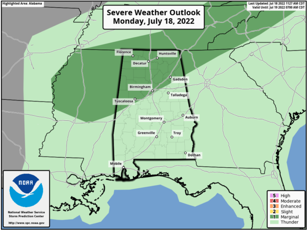
Higher rain chances highlight the forecast this afternoon and evening as a front approaches Alabama from the north. After a relatively quiet and dry weekend, we are expecting scattered to perhaps numerous showers and storms today, and the SPC has parts of North and West Alabama in a “marginal risk” (level 1/5) of severe thunderstorms for this afternoon…this is basically along and north of Interstate 59; Tuscaloosa to Birmingham to Gadsden.
Heavier storms this afternoon could produce strong winds, and all summer storms produce lots of lightning. Also, don’t forget that tropical downpours in summer storms can produce areas of isolated flash flooding. Highs today are in the low 90s for most places, right at seasonal averages for mid-July.
REST OF WEEK: The front stalls to the north of the area, so tomorrow will feature more showers and storms, but that doesn’t mean everyone will see rain. Some locations could get way too much, while other remain bone dry, that’s why we say “feast or famine” when it come to summertime rainfall distribution. On Wednesday, the heat dome to our west, begins to nudge eastward closer to the area and will bring afternoon highs well up into the mid 90s, and with a good bit of humidity, heat advisories may be needed as heat index values may approach 105° in many locations to end the week.
WEEKEND WEATHER: Unfortunately, the heat dome strengthens over the area and high heat values will be expected on both day. Both days will be mostly sunny, with only a low chances of an isolated shower or storm or two, less than 20%. Highs will be in the mid to perhaps upper 90s in both days.
NEXT WEEK: The upper high will be parked over the Deep South, meaning hot, humid days with highs mostly in the mid 90s. Showers and storms are possible during the afternoon and evening hours, but they should be widely separated.
THE TROPICS: The Atlantic Basin is quiet for now with no signs of development through this week. The season is certainly going to become more active the deeper into the season we get. The next few names up are Danielle, Earl, and Fiona.
BEACH FORECAST CENTER: Get the latest weather and rip current forecasts for the beaches from Fort Morgan to Panama City on our Beach Forecast Center page. There, you can select the forecast of the region that you are interested in visiting.
WORLD TEMPERATURE EXTREMES: Over the last 24 hours, the highest observation outside the U.S. was 124.7F at Kastelorizo, Greece. The lowest observation was -101.2F at Concordia, Antarctica.
CONTIGUOUS TEMPERATURE EXTREMES: Over the last 24 hours, the highest observation was 120F at Death Valley, CA. The lowest observation was 30F at Peter Sinks, UT.
Category: Alabama's Weather, ALL POSTS
About the Author (Author Profile)
Macon, Georgia Television Chief Meteorologist, Birmingham native, and long time Contributor on AlabamaWX. Stormchaser. I did not choose Weather, it chose Me. College Football Fanatic. @Ryan_StinnetSubscribe
If you enjoyed this article, subscribe to receive more just like it.


