Midday Nowcast: Another Alabama Scorcher
Another day with more sunshine than clouds and some isolated showers and storms on the radar this afternoon. It’s a scorcher out there with low and mid 90s common across the Alabama landscape.
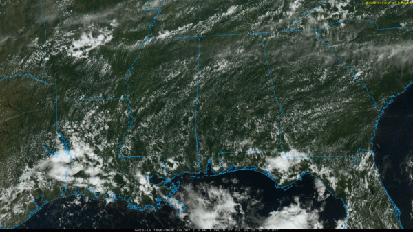
APPROACHING FRONT: The surface boundary to our north will approach the Tennessee Valley tomorrow bringing much higher rain chances across northern portions of the state tomorrow. In fact, the SPC maintains a “marginal risk” (level 1/5) of severe thunderstorms for that part of the state tomorrow where stronger storms will come from strong straight line winds plus heavy rain is likely in spots as well. For the rest of the state, we should remain mainly dry and hot tomorrow with highs in the low to mid 90s.
HIGHER RAIN CHANCES: As we roll into the weekend, the boundary continues to sink south and stalls across North Alabama. This boundary will be the focal point for more numerous showers and storms both Saturday and Sunday, not a “weekend washout” but have back-up plans as you may be dodging rain at times. Rainfall distribution will be very uneven, again, feast or famine. Additionally a few stronger storms are possible and we may have to monitor rainfall trends for areas of isolated flash flooding, due to the high moisture levels in place. The sky will be occasionally cloudy, and highs will be closer to 90° both days.
HELLO AUGUST: More standard summer weather with partly sunny days, fair nights, and scattered, mostly afternoon and evening showers and thunderstorms on a daily basis. Highs will hold mostly in the low to mid 90s. Pretty close to normal for early August in Alabama.
THE TROPICS: The Atlantic Basin remains quiet with no signs of development through the weekend and into next week. The next few names up are Danielle, Earl, and Fiona. The season will pick up in the coming weeks as we enter the heart of the season, late August, September, and early October.
BEACH FORECAST CENTER: Get the latest weather and rip current forecasts for the beaches from Fort Morgan to Panama City on our Beach Forecast Center page. There, you can select the forecast of the region that you are interested in visiting.
WORLD TEMPERATURE EXTREMES: Over the last 24 hours, the highest observation outside the U.S. was 118.8F at Jahra, Kuwait. The lowest observation was -89.0F at Dome A, Antarctica.
CONTIGUOUS TEMPERATURE EXTREMES: Over the last 24 hours, the highest observation was 121F at Death Valley, CA. The lowest observation was 38F at Peter Sinks, UT.
Category: Alabama's Weather, ALL POSTS
About the Author (Author Profile)
Macon, Georgia Television Chief Meteorologist, Birmingham native, and long time Contributor on AlabamaWX. Stormchaser. I did not choose Weather, it chose Me. College Football Fanatic. @Ryan_StinnetSubscribe
If you enjoyed this article, subscribe to receive more just like it.


