Midday Nowcast: More Showers and Storms this Afternoon
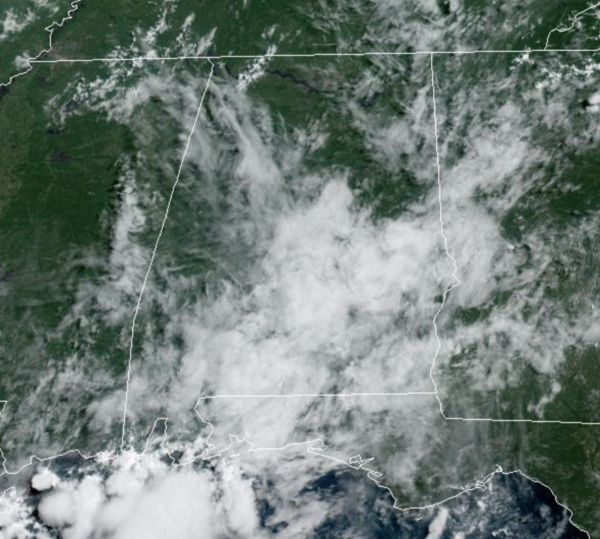
Little change in day to day forecast this week with relatively quiet mornings, but afternoons and evening will be more active with random, scattered to numerous showers and thunderstorms. As in recent days, the showers ands storms will be slow movers, producing heavy rain, strong gusty winds, and lots of lightning. As is common this time of year, rainfall distribution will remain very uneven and it won’t rain everywhere; but odds of any one spot getting wet are in the 50-70 percent range. Highs this week will range from the upper 80s to lower 90s, which is pretty close to average for early to mid August in Alabama. This pattern holds through Thursday so keep an eye on radar trends each day.
FRIDAY AND THE WEEKEND: A surface boundary looks to push into Alabama Friday bringing drier air as we roll into the weekend. Expect fewer showers and storms with more sun than clouds with temperatures remaining the on either side of the 90° mark. Though rain chances are lower, we will still need to mention the chance of a few isolated afternoon showers and storms in the forecast these three days.
TROPICS: A large area of disorganized showers and thunderstorms over the far eastern tropical Atlantic south of the Cabo Verde islands is associated with a tropical wave. Environmental conditions appear generally conducive for gradual development of this system while it moves westward to west-northwestward at 15 to 20 mph across the eastern and central tropical Atlantic, and a tropical depression could form around the middle to latter part of this week.
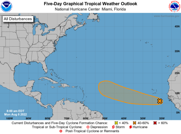
NHC gives it a 40 percent chance of development over the next five days. If anything does form in that region, most likely it will recurve into the open Atlantic well before getting close to the U.S. The Gulf of Mexico remains quiet. Next name up is Danielle.
NEXT WEEK: We will stick with a typical summer forecast through the week. Partly sunny days with afternoon and evening showers and thunderstorms in random, scattered spots. Highs will remain in the upper 80s and low 90s… no sign of any excessive heat issues for our state anytime soon thankfully. See the daily Weather Briefing video for maps, graphics, and more details.
BEACH FORECAST CENTER: Get the latest weather and rip current forecasts for the beaches from Fort Morgan to Panama City on our Beach Forecast Center page. There, you can select the forecast of the region that you are interested in visiting.
WORLD TEMPERATURE EXTREMES: Over the last 24 hours, the highest observation outside the U.S. was 127.4F at Jahra, Kuwait. The lowest observation was -98.3F at Concordia, Antarctica.
CONTIGUOUS TEMPERATURE EXTREMES: Over the last 24 hours, the highest observation was 117F at Death Valley, CA. The lowest observation was 29F at Mackay, ID.
Category: Alabama's Weather, ALL POSTS
About the Author (Author Profile)
Macon, Georgia Television Chief Meteorologist, Birmingham native, and long time Contributor on AlabamaWX. Stormchaser. I did not choose Weather, it chose Me. College Football Fanatic. @Ryan_StinnetSubscribe
If you enjoyed this article, subscribe to receive more just like it.


