Midday Nowcast: More of the Same…Sun and Storms
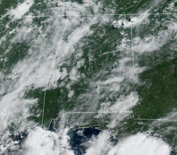
Another relatively quiet morning across Alabama, but this afternoon and evening will feature an active radar with scattered to numerous showers and storms meandering about the Alabama landscape. Showers and storms will continue to be slow movers, producing heavy rain, strong gusty winds, and lots of lightning. We see it everyday, but rainfall distribution will remain very uneven, with some locations getting way too much while others remain dry. Though it won’t rain everywhere, the odds of any one spot getting wet the next few days are in the 50-70 percent range. Highs are generally in the upper 80s to lower 90s each afternoon, before the rain knocks temps down in to the upper 70s and lower 80s. Again, this pattern holds through Thursday with no significant changes in the forecast from day to day.
FRIDAY AND THE WEEKEND: Drier air looks to roll into the much of Alabama by Friday, lasting through the weekend. Expect generally dry conditions with more sun than clouds these three days, and highs on either side of the 90° mark. Though rain chances are much lower, we will still mention the chance of an afternoon shower in the forecast, but the better chances for rain and storms will be across the southern sections of the state and along the Northern Gulf Coast.
TROPICS: Shower and thunderstorm activity has become more limited associated with a tropical wave located a few hundred miles southwest of the Cabo Verde Islands. While some gradual development of this system is possible over the next couple of days, environmental conditions are forecast to become less favorable by this weekend. This system is expected to move westward to west-northwestward at 15 to 20 mph across the tropical Atlantic during the next several days.
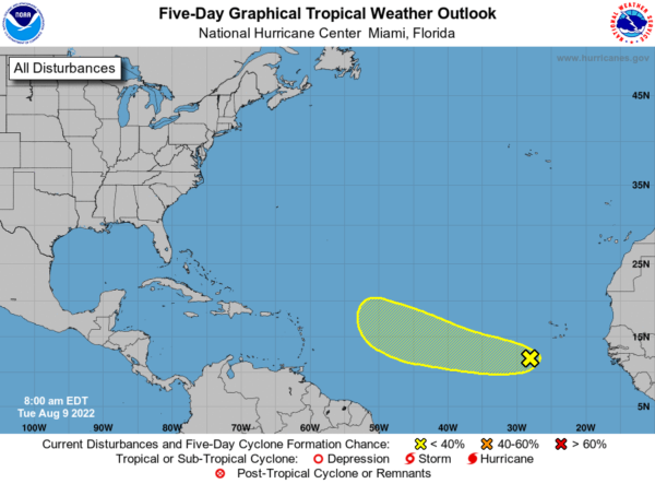
NHC gives it a 30 percent chance of development over the next five days. If anything does form in that region, most likely it will recurve into the open Atlantic well before getting close to the U.S. Next name up is Danielle.
NEXT WEEK: Monday and Tuesday should remain mainly dry, but by mid week we will bring a more typical summer forecast back to North/Central Alabama. Expect partly sunny days with afternoon and evening showers and thunderstorms in random, scattered spots. Highs will remain in the upper 80s and low 90s.
BEACH FORECAST CENTER: Get the latest weather and rip current forecasts for the beaches from Fort Morgan to Panama City on our Beach Forecast Center page. There, you can select the forecast of the region that you are interested in visiting.
WORLD TEMPERATURE EXTREMES: Over the last 24 hours, the highest observation outside the U.S. was 124.7F at Basrah International Airport, Iraq. The lowest observation was -97.4F at Dome C, Antarctica.
CONTIGUOUS TEMPERATURE EXTREMES: Over the last 24 hours, the highest observation was 115F at Death Valley and Stovepipe Wells, CA. The lowest observation was 31F at Choteau, MT.
Category: Alabama's Weather, ALL POSTS
About the Author (Author Profile)
Macon, Georgia Television Chief Meteorologist, Birmingham native, and long time Contributor on AlabamaWX. Stormchaser. I did not choose Weather, it chose Me. College Football Fanatic. @Ryan_StinnetSubscribe
If you enjoyed this article, subscribe to receive more just like it.


