Midday Nowcast: Scattered to Numerous Showers Storms
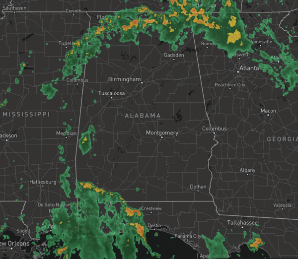
AIR YOU CAN WEAR: The radar is active again today with numerous showers and storms as we remain in a very soupy, moisture-rich air mass. Showers and storms will continue to be slow movers, producing heavy rain, strong gusty winds, and lots of lightning. Also, rainfall distribution will remain very uneven with some locations getting way too much, while others remain dry. With these tropical downpours, it doesn’t take much to get areas of isolated flash flooding to develop. The odds of any one spot getting wet remains in the 50-70 percent range. Afternoon temps are generally in the upper 80s to lower 90s, before the rain knocks temps down in to the upper 70s and lower 80s. Again, this pattern holds into early Friday before things start to change.
RADAR CHECK: Rain and storms are common across the Tennessee Valley today, and we are also watching a cluster of rain and storms associated with the sea breeze front, that are lifting north through the state. These features along with other small scale boundaries in place across the state, we should see the quiet a bit of rain and storms across the state the rest of today.
FRIDAY AND THE WEEKEND: Drier air rolls into much of Alabama Friday, lasting through the weekend. Expect generally dry conditions with more sun than clouds Friday, Saturday and Sunday, lower humidity levels, and highs in the low 90s. Though rain chances are much lower, we will still mention the chance of an isolated afternoon shower in the forecast, but those will be mainly in the southern sections of the state and along the Northern Gulf Coast. Lows this weekend will likely settle into the soothing 60s for much of Central Alabama.
TROPICS: A tropical wave located several hundred miles west-southwest of the Cabo Verde Islands continues to produce disorganized showers and thunderstorms. Some gradual development of this system is still possible over the next few days. However, environmental conditions are forecast to become less favorable by this weekend. This system is expected to move westward to west-northwestward at 15 to 20 mph across the tropical Atlantic during the next several days.
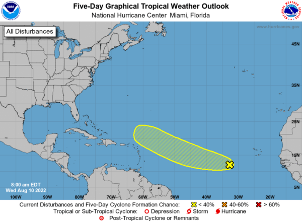
NHC gives it a 30 percent chance of development over the next five days. If anything does form it most likely recurve into the open Atlantic well before getting close to the U.S. Next name up is Danielle.
NEXT WEEK: Monday and Tuesday should remain mainly dry as well, but by mid week we will bring a more typical summer forecast back to North/Central Alabama. Expect partly sunny days with afternoon and evening showers and thunderstorms in random, scattered spots. Highs will remain in the upper 80s and low 90s.
BEACH FORECAST CENTER: Get the latest weather and rip current forecasts for the beaches from Fort Morgan to Panama City on our Beach Forecast Center page. There, you can select the forecast of the region that you are interested in visiting.
WORLD TEMPERATURE EXTREMES: Over the last 24 hours, the highest observation outside the U.S. was 125.2F at Basrah International Airport, Iraq. The lowest observation was -100.8F at Dome C, Antarctica.
CONTIGUOUS TEMPERATURE EXTREMES: Over the last 24 hours, the highest observation was 114F at Death Valley, CA. The lowest observation was 32F at Adin, CA.
Category: Alabama's Weather, ALL POSTS
About the Author (Author Profile)
Macon, Georgia Television Chief Meteorologist, Birmingham native, and long time Contributor on AlabamaWX. Stormchaser. I did not choose Weather, it chose Me. College Football Fanatic. @Ryan_StinnetSubscribe
If you enjoyed this article, subscribe to receive more just like it.


