Midday Nowcast: Rain and Storms Mainly South Today
Periods of rain and storms remain in the forecast Alabama, but today the better rain chances are down across South Alabama, where the surface boundary is today.
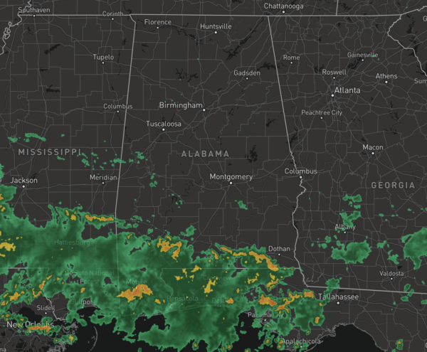
For North and Central Alabama, rain chances are closer to 40%. We are seeing a mix of sun and clouds with temperatures in the mid 80s for most locations across the northern half of Alabama.
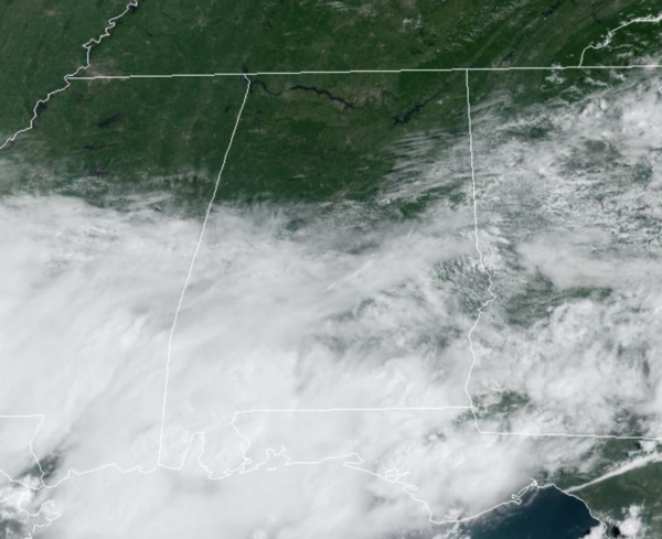
In the coming days, waves of energy will continue to ride along the boundary, meaning rain and storms will remain in the forecast tomorrow through Sunday. It won’t rain all the time and it won’t rain everywhere each day, and no day will be a “wash out”, but certainly keep the rain gear close as rain chances will be in the 50-70% through Sunday. Also, with higher rain chances and clouds temperatures remain below average with mid to upper 80s in the forecast.
Summer storms produce tremendous amounts of lightning, and tropical downpours would could lead to areas of isolated flash flooding. Of course, rainfall distribution will remain very uneven from location to location, and most of the rain and storms will occur during the afternoon and evening hours, but rain and storms are possible at anytime including morning and night.
FOOTBALL WEATHER: For the first week of high school football tomorrow night, some showers and storms will be around at kickoff time. The rain will be scattered, and it certainly won’t rain at all stadiums. But, just be aware that a lightning delay can’t be ruled out in a few places. Temperatures will fall from the low 80s at kickoff into the 70s by the second half.
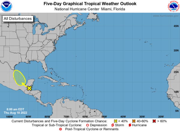
IN THE TROPICS: A concentrated area of showers and thunderstorms is associated with a tropical wave located over northern Guatemala. This system is forecast to move across Central America and southeastern Mexico through tonight before emerging over the Bay of Campeche on Friday, where an area of low pressure could form. After that, additional slow development of this system is possible while it moves northwestward over the southwestern Gulf of Mexico through the weekend. Formation chance through 5 days…low…30 percent.
INTO NEXT WEEK: No real change in the the overall pattern…Expect scattered to numerous showers and storms on a daily basis through the week with some sun along the way. Like this week, most of the showers will come during the afternoon and evening hours, but not necessarily all of them. Highs should continue to hold in the 80s.
BEACH FORECAST CENTER: Get the latest weather and rip current forecasts for the beaches from Fort Morgan to Panama City on our Beach Forecast Center page. There, you can select the forecast of the region that you are interested in visiting.
WORLD TEMPERATURE EXTREMES: Over the last 24 hours, the highest observation outside the U.S. was 125.1F at Kroonstad, South Africa. The lowest observation was -98.7F at Vostok, Antarctica.
CONTIGUOUS TEMPERATURE EXTREMES: Over the last 24 hours, the highest observation was 120F at Death Valley, CA. The lowest observation was 29F at Hamilton, MT.
Category: Alabama's Weather, ALL POSTS
About the Author (Author Profile)
Macon, Georgia Television Chief Meteorologist, Birmingham native, and long time Contributor on AlabamaWX. Stormchaser. I did not choose Weather, it chose Me. College Football Fanatic. @Ryan_StinnetSubscribe
If you enjoyed this article, subscribe to receive more just like it.


