Sunday Weather Video: PTC4 is no more; but Tropics are Heating Up
Greetings from beautiful Pittsburgh, Pennsylvania where I get the pleasure of attending the National Weather Association Annual Meeting this week. My wife says it is like summer camp for meteorologists. She is not wrong!
POTENTIAL TROPICAL CYCLONE 4 turned out to be low potential despite favorable conditions in the Bay of Campeche. It moved into northeastern Mexico overnight. It will bring some beneficial rains to South Texas, however.
ELSEWHERE IN THE TROPICS: It appears that the Atlantic Basin may be awaking from its slumber. The National Hurricane Center is tracking a strong tropical wave that is now moving off the coast of Africa. It appears to have the potential to develop into a tropical cyclone as it moves west-northwestward over the next week. A second tropical wave moving off the coast looks like it could end up being the dominant system. The Bermuda Azores High appears that it will allow it to gain enough latitude to miss the Lesser Antilles, but that solution is not poured in concrete for sure. There are some signals that this second system could impact the East Coast of the United States between Florida and North Carolina around Labor Day. But first, there are other signals in the ensemble data that we could see some close in development over the western Caribbean or Gulf of Mexico by late in the week into the weekend. This system could bring heavy rains to parts of Alabama and Georgia as well as the Florida Panhandle. That will be interesting to watch. Get ready to track some storms.
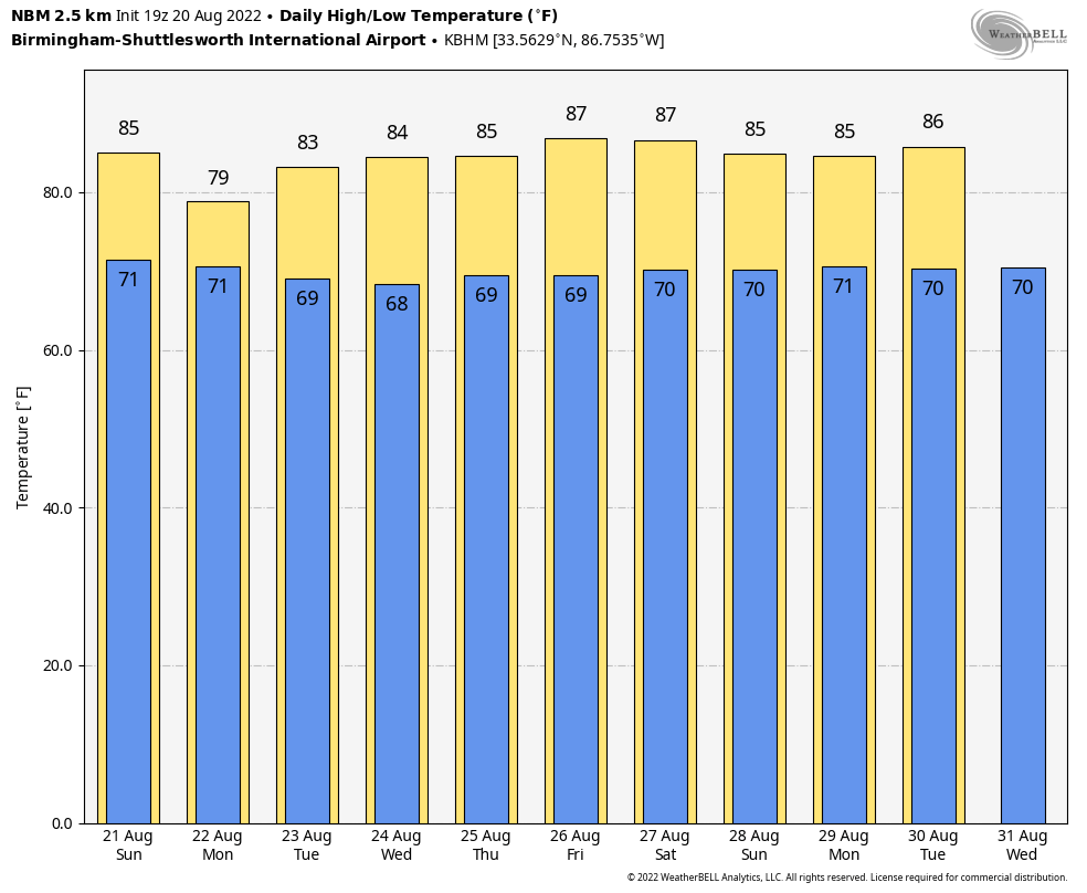
BUT FIRST, FOR YOUR SUNDAY: Mostly cloudy skies greet the day on this late August Sunday. A little patchy fog is even showing up in spots, especially those that got rain from passing thundershowers yesterday afternoon. My house near Acton Road appears to be one of those, picking up around .70 inches in an afternoon downpour. That same storms moved north over the Greater Birmingham Metro area. Highs this afternoon will be comfortable for this time of year, with middle 80s common. The showers and storms will thin out a bit tonight, but may not completely be gone overnight. Look for lows to drop to the 70s areawide.
ON THE WEATHER MAPS this morning we have an upper-level trough extending from the Great Lakes region back to near Memphis. This upper feature is accompanied by a surface low near Chicago with a trailing front that is trying to pass the Missouri Bootheel this morning. This trough appeared that it would swing through Alabama tomorrow, but the latest data suggests that it may pass further to our north, keeping our rain chances higher than expected for much of the week ahead.
START TO THE NEW WORK WEEK: Moisture levels are high across Alabama, with higher than average precipitable water values and high dewpoints at the surface making it feel quite muggy. Some additional moisture will try to work its way in from the west tomorrow, raising those rain chances even further. It looks like showers and thunderstorms will be fairly numerous across the area tomorrow, diminishing tomorrow evening. Highs may not get out of the upper 70s in some locations tomorrow. Quite nice for August in Alabama.
MIDWEEK PERIOD: Drier air may push down into the Tennessee Valley starting Tuesday, but it appears that it will have a harder time digging much further into Alabama. This means a little drier for the North, but doses of scattered mainly afternoon and evening showers and storms each day Tuesday through Thursday. Wednesday looks like it might be the drier of the three days. Highs will trend back to the middle and upper 80s. Lows will be in the upper 60s to near 70 degrees.
RAINFALL AMOUNTS: Looks like fairly widespread 2-inch rainfall amounts will be common across Central Alabama, with lesser amounts to the north.
WEEKEND: Next weekend is the fabulous Sidewalk Film Festival and we may all be dodging a few splash and dash showers as we make our way between the film venues across Birmingham. No washouts, however, just keep the rain gear handy. Same for our Thursday and Friday night high school football games. Temperatures will still be in the 80s by day and near 70F by night.
VOODOO TERRITORY: I guess it technically is weekend territory, but since the forecast is still very uncertain, I will talk about the potential of low pressure developing over the Gulf by next weekend. It has been a consistent signal of the global models, both in their deterministic runs, and the ensemble members. It looks like a tropical wave over the northwestern Caribbean could close out and become a tropical cyclone by late Friday into early Saturday. Persistent troughiness over the southeastern United States could pull such a feature northward toward the Gulf Coast. If it dos head toward the Central Gulf States, including Alabama, heavy rain could be in the offing.
BEACHCAST: Showers and thunderstorms look like they will be a fixture along the beautiful beaches of Alabama and Northwest Florida this week. Mostly in the late mornings and afternoon, but possible about anytime. It will be warm and humid, with daytime highs in the mid-80s and water temperatures about the same. Lows will be in the muggy upper 70s. Low rip current risk through midweek.
Click here to see the Beach Forecast Center page.
NATIONALLY: Flood watches are in effect today across the Arklatex into southern Arkansas as 2-5 inches of rain with up to 8 inches expected in spots. Places from the Dallas-Ft. Worth Metroplex up to Wichita Falls, over to Tyler, Shreveport, and Monroe, Louisiana are in the watches.
DANCING WITH THE STATS: 1.90 inches of rain fell yesterday at Tuscaloosa, besting the former record for the date of 1.83 inches set in 2009.
ADVERTISE WITH US: Deliver your message to a highly engaged audience by advertising on the AlabamaWX.com website. The site enjoyed over 29 MILLION page views in the past 12 months. Don’t miss out! We can customize a creative, flexible, and affordable package that will suit your organization’s needs. Contact me, Bill Murray, at (205) 687-0782 and let’s talk.
WEATHERBRAINS: This week, the panel will entertain. Check out the show at www.WeatherBrains.com. You can also subscribe on iTunes. You can watch the show live at on the WeatherBrains YouTube Channel You will be able to see the show on the James Spann 24×7 weather channel on cable or directly over the air on the dot 2 feed.
ON THIS DATE IN 1992: On Friday morning the 21st, Tropical Storm Andrew was located a little under 500 miles north of Puerto Rico, moving west northwest. The storm was slowly strengthening uner favorable upper air conditions and was forecast to become a hurricane within 24 hours. The official forecast brought the storm to the east of the northern Bahamas by the following Monday morning, and to Florida on Tuesday or Wednesday. By the afternoon, Emergency Management Officials across Florida were told that nothing should happen during the weekend, letting their guard down. Andrew would strengthen dramatically and move westward faster than anticipated, making landfall south of Miami on Sunday night as a Category 4 Hurricane. Follow my weather history tweets on Twitter. I am @wxhistorian at Twitter.com.
Category: Alabama's Weather, ALL POSTS, Tropical
About the Author (Author Profile)
Bill Murray is the President of The Weather Factory. He is the site's official weather historian and a weekend forecaster. He also anchors the site's severe weather coverage. Bill Murray is the proud holder of National Weather Association Digital Seal #0001 @wxhistorianSubscribe
If you enjoyed this article, subscribe to receive more just like it.


