Flood Watch For North Alabama Today; Wet Pattern Continues
RADAR CHECK: Rain is fairly widespread early this morning over parts of North and West Alabama as an unsettled, wet pattern persists. A flood watch is in effect today for areas north of a line from Reform to Clanton to Opelika, roughly the northern half of the state. Showers are possible over South Alabama as well this afternoon, but they should be fewer in number there.
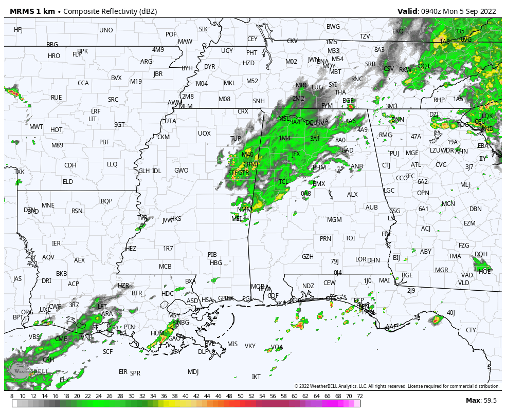
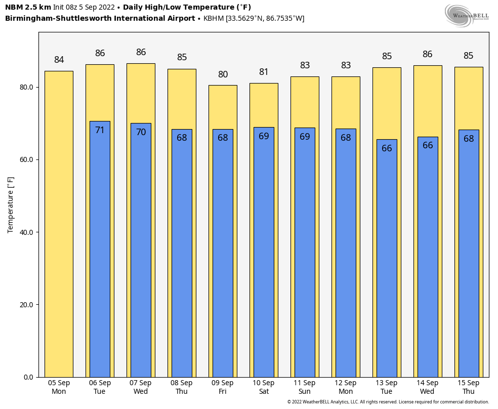
The ground is saturated over much of North Alabama, and we expect periods of rain and a few thunderstorms again today, possibly leading to some flooding issues. The sky will be mostly cloudy with a high between 78 and 83 degrees for most communities. The average high for Birmingham on September 5 is 88.
REST OF THE WEEK: Showers and storms remain possible tomorrow and Wednesday, but they should be a little fewer in number and more scattered in nature. With a mix of sun and clouds we expect a high in the mid 80s both days. Then, rain and storms become more widespread again Thursday and Friday as precipitable water values rise across the state. Highs will be close to 80, and we can’t rule out more flooding issues by the end of the week as the wet pattern continues.
THE ALABAMA WEEKEND: The sky will be mostly cloudy Saturday and Sunday with occasional showers and a few thunderstorms both days. Again, this won’t be an “all day” kind of rain, but if you have an outdoor event planned you will have to dodge rain from time to time. Highs over the weekend will be in the low 80s.
NEXT WEEK: We are seeing evidence drier, continental air could move into Alabama for at least the first half of next week with increasing amounts of sun. Highs will be in the 80s… See the daily Weather Briefing video for maps, graphics, and more details.
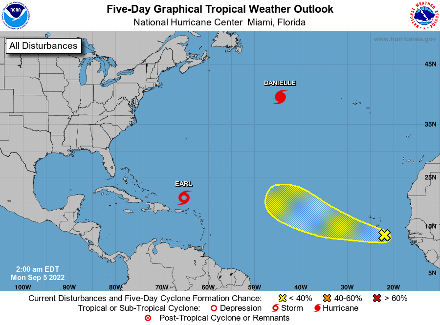
TROPICS: Hurricane Danielle, with winds of 90 mph, is in the North Atlantic between the U.S. and Europe. It will move eastward over the next few days, and will become post-tropical later in the week. Tropical Storm Earl, with winds of 50 mph, is well north of Puerto Rico, and will move slowly northward through mid-week, possibly reaching hurricane strength. Both of these systems will stay well east of the U.S.
A tropical wave in the far eastern Atlantic could show some development this week, but it should recurve into the open Atlantic. There are no tropical systems threatening the U.S. for at least the next 7 to 10 days.
ON THIS DATE IN 1950: Hurricane Easy was an erratic and unpredictable hurricane that lingered over the Tampa Bay area for days, dropping torrential rains and causing damage especially in Cedar Key, Florida where the storm eventually made landfall. This hurricane dumped 38.7 inches of rain in 24 hours in Yankeetown, a record for the U.S. at the time.
ON THIS DATE IN 2017: Hurricane Irma became a category 5 hurricane with maximum sustained winds of 180 mph. This made Irma one of strongest hurricane ever observed in the open Atlantic Ocean.
ON THIS DATE IN 2019: After battering the Bahamas, Hurricane Dorian turned northwestward and moved parallel to the southern U.S. East Coast. Bands of showers and thunderstorms ahead of the storm’s center produced over a dozen tornadoes across northeastern South Carolina and eastern North Carolina during the morning of Wednesday, September 5. Fortunately for South Carolina and southeastern North Carolina, Dorian continued to turn to the right and the center remained offshore as it approached Cape Fear.
BEACH FORECAST: Click here to see the AlabamaWx Beach Forecast Center page.
We are on a holiday schedule, so just one video today, but I will post fresh forecast notes here by 3:00 this afternoon… enjoy the day!
Category: Alabama's Weather, ALL POSTS, Weather Xtreme Videos
About the Author (Author Profile)
James Spann is one of the most recognized and trusted television meteorologists in the industry. He holds the AMS CCM designation and television seals from the AMS and NWA. He is a past winner of the Broadcast Meteorologist of the Year from both professional organizations.Subscribe
If you enjoyed this article, subscribe to receive more just like it.


