Midday Nowcast: Some Sun, Some Clouds, and Mainly Dry Today
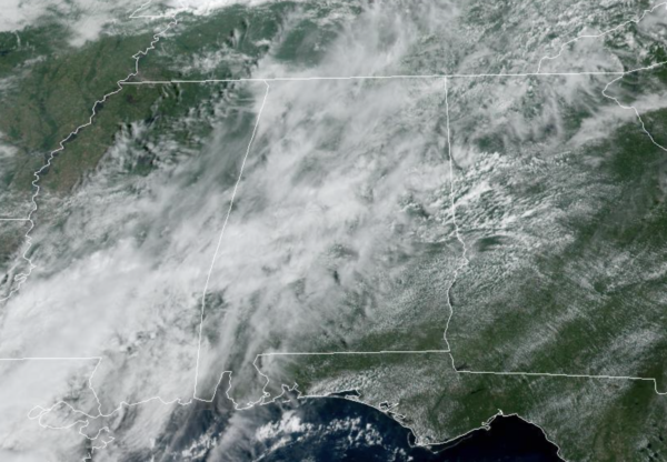
We are seeing a mix of sun and clouds, with lower rain chances as only a few showers and storms are in the forecast today. Most locations will remain dry and afternoon temperatures will range from the mid to upper 80s for most locations. For tomorrow and Thursday, we are looking at a very routine late September forecast…Humid days with highs in the mid to upper 80s, a mix of sun and clouds, and scattered showers and storms, mainly during the afternoon and evening hours. Rain chances these two days are in the 40-50% range.
WET WEEKEND AHEAD: An upper trough develops over the Southeast, and with a deep fetch of tropical moisture returning to the state, showers and storms become more numerous and widespread Friday, continuing at times Saturday and Sunday. The rain could be heavy at times, and some flooding issues can’t be ruled out with the saturated soil conditions. Not a weekend washout, and you will see some sun at times, but occasional showers are likely. Highs will be bear 80° due to clouds and rain.
TROPICS: Hurricane Danielle, with winds of 75 mph, is in the North Atlantic between the U.S. and Europe. It will move eastward over the next few days, and will become post-tropical later in the week. Tropical Storm Earl, with winds of 65 mph, is well north of Puerto Rico, and will move slowly northward through mid-week. It is expected to become a hurricane. Both of these systems will stay well east of the U.S.
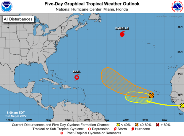
Elsewhere, disorganized showers and thunderstorms persist from the Cabo Verde Islands southwestward several hundred miles in association with a broad area of low pressure. Environmental conditions are conducive for some development of this system, and a tropical depression could form in a few days while moving westward to west-northwestward at 15 to 20 mph over the eastern and central tropical Atlantic. Upper-level winds are likely to become less conducive for development late this week. Formation chance through 5 days…medium…60 percent.
A tropical wave currently located over western Africa is forecast to emerge offshore into the eastern Atlantic in a day or two. Environmental conditions appear generally conducive for some slow development thereafter as the system moves west-northwestward over the eastern tropical Atlantic. Formation chance through 5 days…low…20 percent.
If these features develop, they would be Fiona and Gaston, and are expected to recurve out into the Atlantic.
NEXT WEEK: It still looks wet on Monday, but the models continue to show a front possibly swinging through the state, delivering a drier, continental air mass into the state by Tuesday. If this occurs, much of next week, should feature more sunshine, little if any rainfall, and highs in the 80s.
BEACH FORECAST CENTER: Get the latest weather and rip current forecasts for the beaches from Fort Morgan to Panama City on our Beach Forecast Center page. There, you can select the forecast of the region that you are interested in visiting.
WORLD TEMPERATURE EXTREMES: Over the last 24 hours, the highest observation outside the U.S. was 122.0F at Touggourt, Algeria. The lowest observation was -94.9F at Amundsen-Scott South Pole Station, Antarctica.
CONTIGUOUS TEMPERATURE EXTREMES: Over the last 24 hours, the highest observation was 121F at Death Valley, CA. The lowest observation was 29F at Peter Sinks, UT.
Category: Alabama's Weather, ALL POSTS
About the Author (Author Profile)
Macon, Georgia Television Chief Meteorologist, Birmingham native, and long time Contributor on AlabamaWX. Stormchaser. I did not choose Weather, it chose Me. College Football Fanatic. @Ryan_StinnetSubscribe
If you enjoyed this article, subscribe to receive more just like it.


