Midday Nowcast: Sun Today, Rain Tomorrow
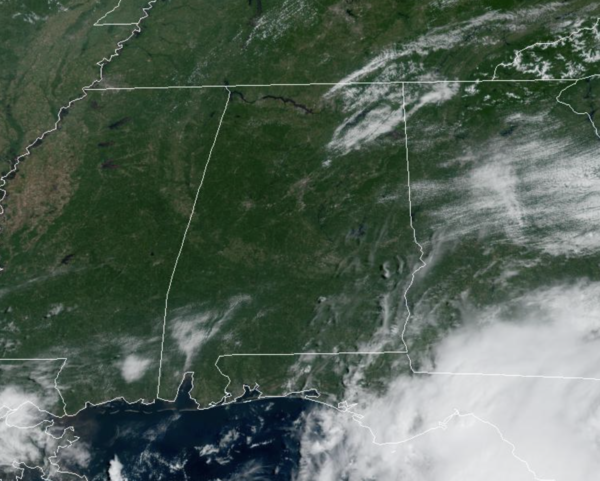
Today is a relatively dry day for the northern half of the state, and we are seeing more sun than clouds. Temperatures this afternoon are in the mid to upper 80s. The better chance for rain today is across the southern and southeastern continues of the state. Tonight, moisture begins to surge north and it will become mainly cloudy.
WET END TO WEEK: An upper trough and surface low to the south will send deep tropical moisture north into Alabama, almost assuring us a very wet Friday across the state. Showers and storms become more numerous and widespread, and the unsettled weather will continue into Saturday and Sunday. The rain will be heavy at times, and some flooding issues could develop with the saturated soil conditions. It is not going to rain all the time, but occasional showers and storms are likely. Highs will be in the upper 70s tomorrow with rain chances closer to 90%. They’ll be in the 60-70% range Saturday and Sunday. Average rainfall totals for much of the state will be in the once inch range, with isolated higher amounts possible.
FOOTBALL WEATHER: For the high school games across Alabama tomorrow night, periods of rain are likely with temperatures in the 70s.
Saturday, Alabama will take on Texas in Austin (11a CT kickoff)… the sky will be sunny with temperatures rising from near 90 at kickoff, into the mid 90s during the second half.
Auburn will host San Jose State Saturday evening at Jordan-Hare Stadium (6:30p CT kickoff)… the sky will be mostly cloudy with showers possible during the game. Temperatures will hover in the mid to upper 70s.
UAB plays at Liberty Saturday in Lynchburg, VA (5p CT kickoff)… the sky will be mostly clear with temperatures falling from 80 at kickoff, to near 70 by the final whistle.
TROPICS: Danielle has become Post-Tropical with winds of 65 mph, is in the moving east towards Europe. Hurricane Earl, with winds of 105 mph, is close to Bermuda, and continues northward. Both of these systems will stay well east of the U.S.
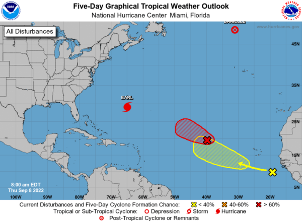
Elsewhere, an area of low pressure located almost a thousand miles west-northwest of the Cabo Verde Islands is producing a concentrated area of disorganized showers and thunderstorms primarily east of its center. Environmental conditions appear only marginally conducive for additional development of this system, but only a small increase in organization could result in the formation of a short-lived tropical depression or storm later today while it moves westward to west-northwestward at 15 to 20 mph over the central tropical Atlantic. After that time, upper-level winds are forecast to become less conducive for development. Formation chance through 48 hours…high…70 percent.
Plus, a tropical wave has recently emerged off the west coast of Africa this morning and is producing an area of disorganized showers and thunderstorms. Environmental conditions appear conducive for some gradual development as the system moves generally west-northwestward over the eastern tropical Atlantic. Formation chance through 5 days…low…30 percent.
If these features develop, they would be Fiona and Gaston, and are expected to recurve out into the Atlantic.
NEXT WEEK: Monday will remains wet, by Tuesday a strong front swings through the state, delivering a much drier, continental air mass into the state. This will clear out the humidity and rain chances, allowing for lots of sunshine, and highs in the 80s. Lows are likely to fall into the 50s for many locations. This will bring a a true hint of fall to Alabama next week.
BEACH FORECAST CENTER: Get the latest weather and rip current forecasts for the beaches from Fort Morgan to Panama City on our Beach Forecast Center page. There, you can select the forecast of the region that you are interested in visiting.
WORLD TEMPERATURE EXTREMES: Over the last 24 hours, the highest observation outside the U.S. was 113.4F at Adrar, Algeria. The lowest observation was -103.4F at Vostok, Antarctica.
CONTIGUOUS TEMPERATURE EXTREMES: Over the last 24 hours, the highest observation was 122F at Death Valley, CA. The lowest observation was 31F at Crescent, OR.
Category: Alabama's Weather, ALL POSTS
About the Author (Author Profile)
Macon, Georgia Television Chief Meteorologist, Birmingham native, and long time Contributor on AlabamaWX. Stormchaser. I did not choose Weather, it chose Me. College Football Fanatic. @Ryan_StinnetSubscribe
If you enjoyed this article, subscribe to receive more just like it.


