Midday Nowcast: Hot September Days; Tropics Heating Up Too
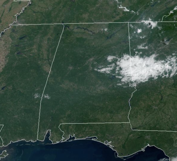
The heat is the story for the next couple of day across Alabama as an upper-ridge builds in over the region. We are seeing abundant sunshine and highs today and tomorrow will reach towards the mid 90s. Rain chances are very low, but not zero, and some of the mesoscale models are hinting that a few pop-up showers are possible this afternoon across the state, but these if any, will be few with rain chances under 10%.
FALL ARRIVES: Thursday will remain hot with highs in the low 90s, but late in the day, a dry cold front will pass through the state. It will be moisture starved so rain is not expected. Thursday will be the first day of fall as the autumnal equinox occurs at 8:03PM CDT.
FRIDAY AND THE WEEKEND: Behind the front, Friday will be noticeably cooler with a high in the low 80s. Many places over North Alabama will see lows in the 50s early Friday and Saturday morning, making it feel like fall. Saturday will be a sunny day with a high in the mid 80s. Most of Sunday looks dry with a high in the 80s, but we will bring in a chance of showers Sunday afternoon and evening as another cold front begins to move through the state. Rain amounts should be light, generally under 1/4 inch.
NEXT WEEK: Showers end early Monday; the temperatures will hold in the 70s much of the day. Then, the rest of the week looks generally dry and very night, with highs near 80° most days, and lows closer to 60°, pretty close to average values for late September.
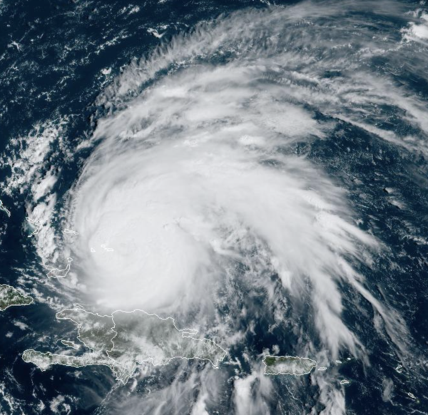
HURRICANE FIONA: Fiona is a very powerful hurricane impacting the Turks and Caicos today. At 1100 AM EDT, the center of Hurricane Fiona was located near latitude 22.0 North, longitude 71.4 West. Fiona is moving toward the north-northwest near 9 mph. This general motion is expected to continue through today, followed by a turn toward the north tonight or Wednesday. On the forecast track, the center of Fiona will continue to move near the eastern Turks and Caicos during the next few hours, away from those islands by tomorrow, and approach Bermuda late on Thursday, as a significant threat.
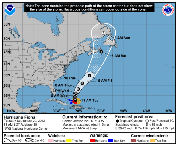
Maximum sustained winds remain near 115 mph with higher gusts. Fiona is a category 3 hurricane on the Saffir-Simpson Hurricane Wind Scale. Strengthening is forecast during the next couple of days. Hurricane-force winds extend outward up to 30 miles from the center and tropical-storm-force winds extend outward up to 150 miles. The minimum central pressure estimated from NOAA and Air Force Hurricane Hunter aircraft observations is 961 mb (28.38 inches).
Elsewhere, two other features the NHC is monitoring, one should become Gaston very soon, while the other could become Hermine late this week or weekend.
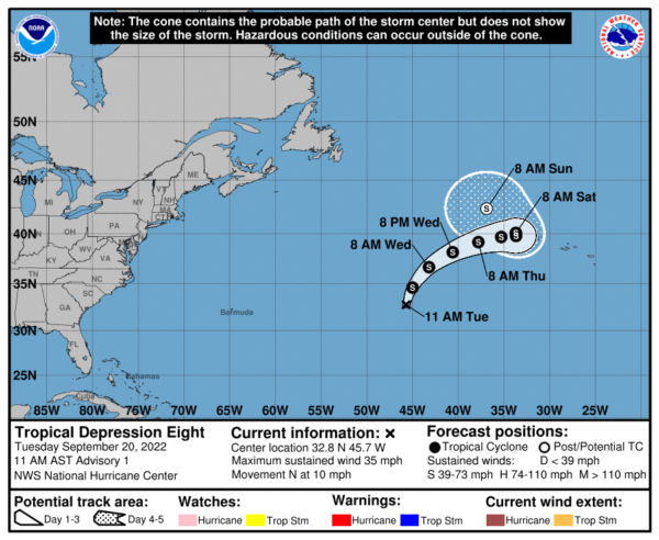
Tropical Depression Eight has formed over the North/Central Atlantic and it no threat to the U.S. It will only impact the shipping lanes and perhaps the Azores by the weekend and again should become Gaston. At 1100 AM AST, the center of Tropical Depression Eight was located near latitude 32.8 North, longitude 45.7 West. The depression is moving toward the north near 10 mph. A turn to the northeast is expected on Wednesday, followed by a motion to the east. Maximum sustained winds are near 35 mph with higher gusts. Slow strengthening is forecast, and the depression is expected to become a tropical storm later today or tonight. The estimated minimum central pressure is 1013 mb (29.92 inches).
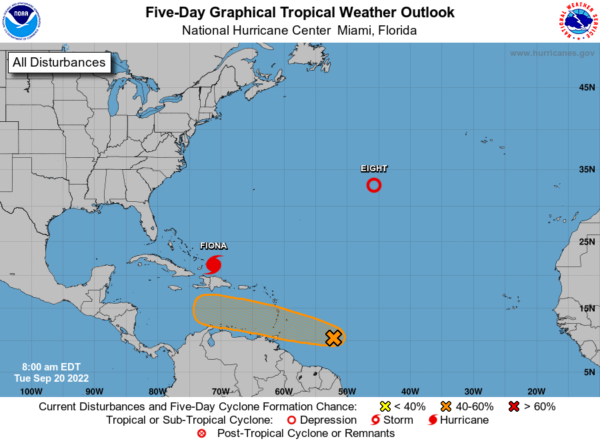
Finally, a tropical wave located several hundred miles east of the Windward Islands is producing a broad area of disorganized showers and thunderstorms while moving westward at 15-20 mph. Gradual development of this system is forecast during the next several days as the system approaches the Windward Islands, and a tropical depression could form by the latter part of this week as the system moves into the eastern and central Caribbean sea. Formation chance through 5 days…medium…50 percent. This one we will have to keep an eye on, as model data suggest this has a decent chance to make it into the Gulf of Mexico in about 8-10 days, as a potentially significant system. Don’t bet alarmed by what you may see online in the coming days, because there will be plenty of morons and trolls showing the worst possible outcomes of this system from model run to model run; just know we will be watching it. At this time, there is no way of knowing if, when, where, or what it will be by the middle of next week.
BEACH FORECAST CENTER: Get the latest weather and rip current forecasts for the beaches from Fort Morgan to Panama City on our Beach Forecast Center page. There, you can select the forecast of the region that you are interested in visiting.
WORLD TEMPERATURE EXTREMES: Over the last 24 hours, the highest observation outside the U.S. was 123.6F at Kroonstad, South Africa. The lowest observation was -95.8F at Vostok, Antarctica.
CONTIGUOUS TEMPERATURE EXTREMES: Over the last 24 hours, the highest observation was 105F at Coolidge, AZ. The lowest observation was 26F at Peter Sinks, UT and Bondurant, WY.
Category: Alabama's Weather, ALL POSTS
About the Author (Author Profile)
Macon, Georgia Television Chief Meteorologist, Birmingham native, and long time Contributor on AlabamaWX. Stormchaser. I did not choose Weather, it chose Me. College Football Fanatic. @Ryan_StinnetSubscribe
If you enjoyed this article, subscribe to receive more just like it.


