4 pm NHC Update: Ian Intensifies Into a Hurricane Once Again; More Watches & Warnings Issued
SUMMARY OF 500 PM EDT…2100 UTC…INFORMATION
———————————————-
LOCATION…29.3 N, 79.9 W
ABOUT 240 MI…390 KM S OF CHARLESTON, SOUTH CAROLINA
ABOUT 335 MI…540 KM SSW OF CAPE FEAR, NORTH CAROLINA
MAXIMUM SUSTAINED WINDS…75 MPH…120 KM/H
PRESENT MOVEMENT…NNE OR 30 DEGREES AT 10 MPH…17 KM/H
MINIMUM CENTRAL PRESSURE…986 MB…29.12 INCHES
WATCHES AND WARNINGS
——————–
A Storm Surge Warning is in effect for…
* Flagler/Volusia Line to Cape Fear
* Neuse River
* St. Johns River
A Hurricane Warning is in effect for…
* Savannah River to Cape Fear
A Tropical Storm Warning is in effect for…
* Vero Beach, Florida to Savannah River
* Cape Fear to Duck, North Carolina
* Pamlico Sound
A Storm Surge Watch is in effect for…
* North of Cape Fear to Duck, North Carolina
* Pamlico River
* Cape Fear River
A Hurricane Watch is in effect for…
* Flagler/Volusia County Line to the Savannah River
* East of Cape Fear to Surf City
DISCUSSION AND OUTLOOK
———————-
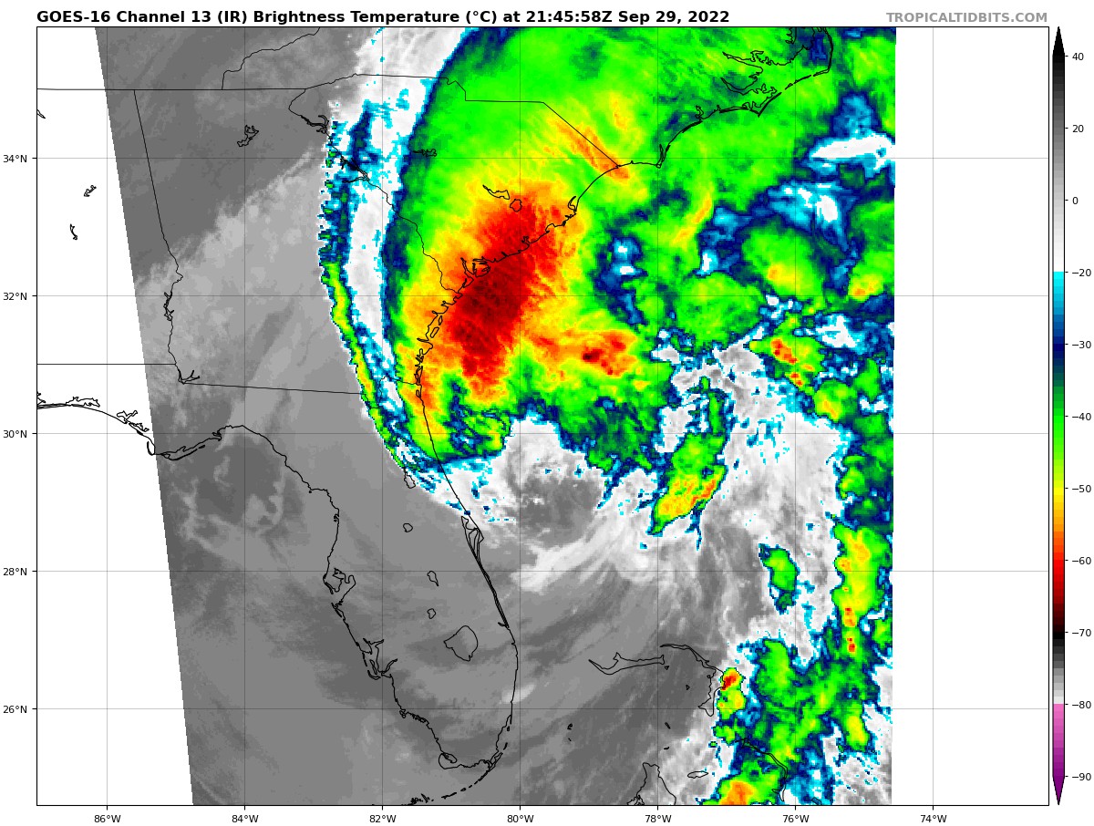
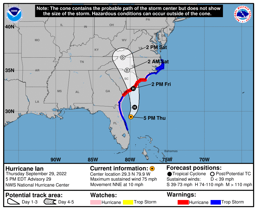
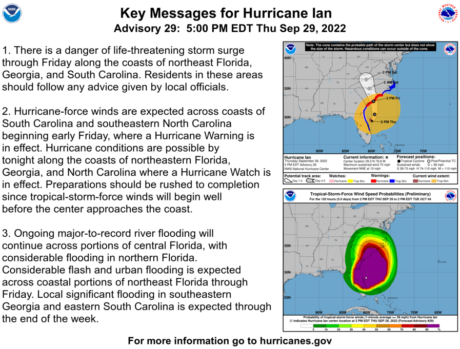
At 500 PM EDT (2100 UTC), the center of Hurricane Ian was located near latitude 29.3 North, longitude 79.9 West. Ian is moving toward the north-northeast near 10 mph (17 km/h). A turn toward the north is expected tonight, followed by a turn toward the north-northwest with an increase in forward speed Friday night. On the forecast track, Ian will approach the coast of South Carolina on Friday. The center will move farther inland across the Carolinas Friday night and Saturday.
Maximum sustained winds have increased to near 75 mph (120 km/h) with higher gusts. Ian could slightly strengthen before landfall tomorrow, and is forecast to rapidly weaken over the southeastern United States late Friday into Saturday.
Hurricane-force winds extend outward up to 45 miles (75 km) from the center, and tropical-storm-force winds extend outward up to 415 miles (665 km). Kennedy Space Center Tower 1 recently reported a wind gust to 89 mph (145 km/h). The estimated minimum central pressure is 986 mb (29.12 inches).
HAZARDS AFFECTING LAND
———————-
STORM SURGE: The combination of storm surge and the tide will cause normally dry areas near the coast to be flooded by rising waters moving inland from the shoreline. The water could reach the following heights above ground somewhere in the indicated areas if the peak surge occurs at the time of high tide…
* Edisto Beach to Murrells Inlet…4-7 ft
* Flagler/Volusia County Line to Edisto Beach…4-6 ft
* Murrells Inlet to Cape Fear…3-5 ft
* Cape Fear River…2-4 ft
* St. Johns River…2-4 ft
* East of Cape Fear to Duck, including Pamlico and Neuse Rivers…2-4 ft
* Patrick Air Force Base to Flagler/Volusia County Line…1-3 ft
* Albemarle Sound…1-2 ft
The deepest water will occur along the immediate coast near and to the right of the center, where the surge will be accompanied by large waves. Surge-related flooding depends on the relative timing of the surge and the tidal cycle, and can vary greatly over short distances. For information specific to your area, please see products issued by your local National Weather Service forecast office.
WIND: Hurricane conditions are expected to begin in the Hurricane Warning area starting early Friday, with tropical storm conditions beginning overnight.
Tropical storm conditions are now occurring in parts of the warning area on the east coasts of Florida and should spread northward along the Georgia and North Carolina coasts today through Friday. Hurricane conditions are possible within the Hurricane Watch area in northeastern Florida and Georgia today into Friday, and in the watch area in North Carolina on Friday morning.
RAINFALL: Ian is expected to produce the following storm total rainfall:
* Coastal Georgia: 1 to 3 inches, with locally higher amounts.
* Northeast South Carolina: 4 to 8 inches, with local maxima of 12 inches
* Upstate and central South Carolina, North Carolina, and southern Virginia: 3 to 6 inches, with local maxima of 8 inches across northwest North Carolina and southwest Virginia.
Major-to-record river flooding will continue across central Florida through next week. Considerable flash and urban flooding, and minor river flooding, is possible across South Carolina through Friday. Locally considerable flash, urban, and small stream flooding is possible this weekend across portions of northwest North Carolina and southwest Virginia. Limited flooding is possible across portions of the southern Mid-Atlantic.
TORNADOES: A few tornadoes will be possible Friday across the coastal Carolinas and southeast Virginia.
SURF: Swells generated by Ian are affecting the northern coast of Cuba, the northeastern coast of the Yucatán peninsula, Florida and Georgia. Swells will increase along the coasts of South Carolina and North Carolina. These swells are likely to cause life-threatening surf and rip current conditions. Please consult products from your local weather office.
Category: ALL POSTS, Severe Weather, Tropical
About the Author (Author Profile)
Scott Martin is an operational meteorologist, professional graphic artist, musician, husband, and father. Not only is Scott a member of the National Weather Association, but he is also the Central Alabama Chapter of the NWA president. Scott is also the co-founder of Racecast Weather, which provides forecasts for many racing series across the USA. He also supplies forecasts for the BassMaster Elite Series events including the BassMaster Classic.Subscribe
If you enjoyed this article, subscribe to receive more just like it.


