Long Dry Spell Continues; Ian Remains Far To The East
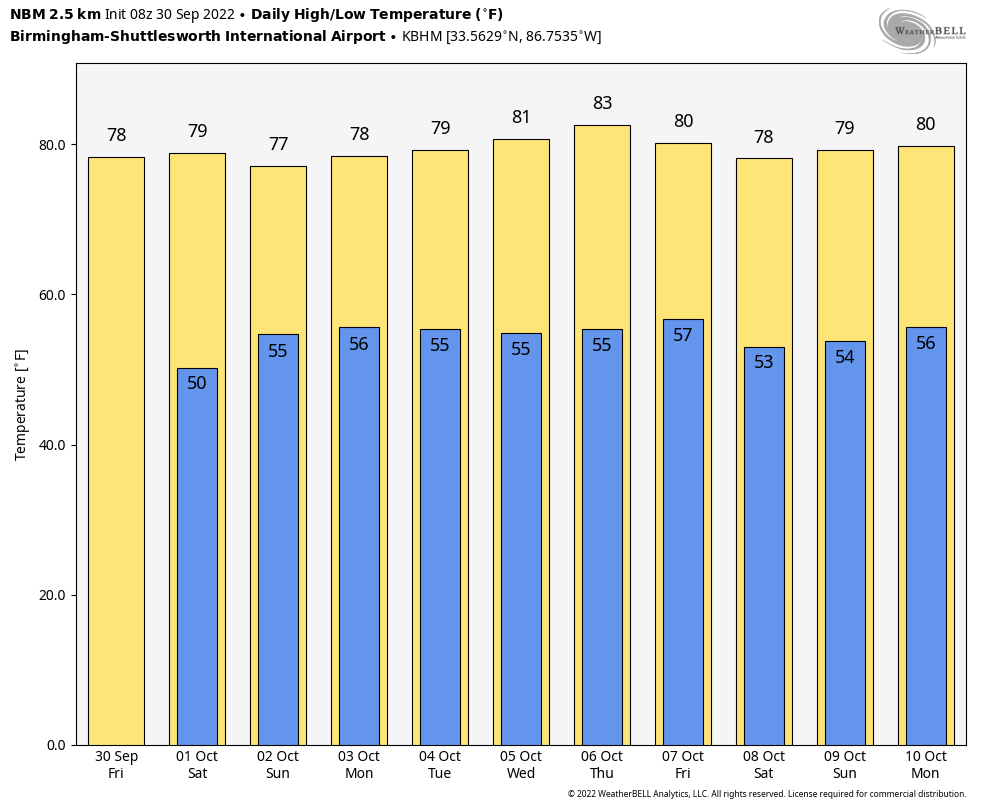
DRY AUTUMN WEATHER CONTINUES: Alabama’s weather won’t change much for the next 7-10 days as the dry pattern continues. We are forecasting sunny pleasant days and fair cool nights over the weekend, and through all of next week. Highs will be in the mid to upper 70s over the weekend, and close to 80 degrees most of next week. Lows will be mostly in the 50s. See the daily Weather Briefing video for maps, graphics, and more details.
FOOTBALL WEATHER: For the high school games in the state tonight, the sky will be mostly clear with temperatures falling through the 60s.
Tomorrow, Alabama travels to Fayetteville to take on Arkansas (2:30p CT kickoff)… the sky will be sunny with a temperature around 80 degrees as the game begins. No risk of rain.
Auburn hosts LSU tomorrow evening (6:00p CT kickoff) at Jordan-Hare Stadium. The sky will be mostly fair with temperatures falling from near 72 at kickoff, into the 60s during the game.
UAB will be in Houston to take on Rice (6:30p CT kickoff)… the sky will be clear with temperatures falling from the low 80s at kickoff into the mid 70s by the final whistle.
RACE WEEKEND: The weekend looks great for Talladega as Ian stays to the east. Expect a good supply of sunshine tomorrow and Sunday with highs in the mid to upper 70s.
RAIN UPDATE: Here are some rain totals across Alabama for the year so far, and the departure from average. Despite the dry conditions over the past few weeks, some communities (including Birmingham) still have a healthy surplus.
Birmingham 51.67″ (+7.62″)
Mobile 50.08″ (-2.83″)
Tuscaloosa 47.54″ (+7.25″)
Montgomery 45.78″ (+6.45″)
Huntsville 41.70″ (+1.22″)
Anniston 40.07″ (+0.44″)
Muscle Shoals 39.33″ (-1.69″)
Dothan 38.81″ (-3.58″)
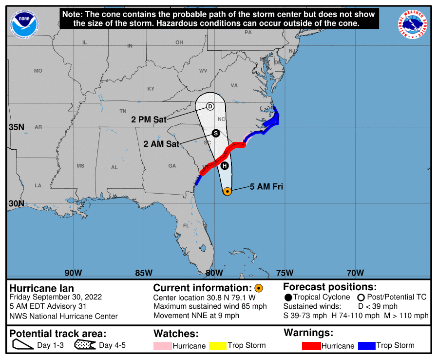
TROPICS: Hurricane Ian will make another landfall today on the coast of South Carolina north of Charleston. Winds are 85 mph early this morning; strengthening is not expected before the center reaches the coast as dry air is working into the system, and strong shear conditions are in place.
Elsewhere, tropical depression eleven has dissipated far from land. And, a new wave will emerge off the coast of Africa tonight; NHC gives it a medium change (50 percent) of development over the next five days in the far eastern Atlantic. The rest of the Atlantic basin is quiet.
ON THIS DATE IN 1896: A hurricane formed on September 22 and lasted until September 30. It formed directly over the Lesser Antilles and hit Cuba, Florida, Georgia, South and North Carolina, Virginia, Washington D.C., and Pennsylvania. Its maximum sustained winds were at 130 mph. The heaviest rainfall deposited in association with the storm was 19.96 inches at Glennville, Georgia. This hurricane was responsible for an estimated 130 deaths.
BEACH FORECAST: Click here to see the AlabamaWx Beach Forecast Center page.
I will be live at Corner High School for the Friday Night Rivals game this evening on ABC 33/40… so no afternoon video today, but I will post fresh forecast notes later today. Enjoy the weekend!
Category: Alabama's Weather, ALL POSTS, Weather Xtreme Videos
About the Author (Author Profile)
James Spann is one of the most recognized and trusted television meteorologists in the industry. He holds the AMS CCM designation and television seals from the AMS and NWA. He is a past winner of the Broadcast Meteorologist of the Year from both professional organizations.Subscribe
If you enjoyed this article, subscribe to receive more just like it.


