Midday Nowcast: Awesome Autumn Weather; Ian Nearing Carolina Coast

AWESOME AUTUMN WEATHER: Delightful weather continues today and through the weekend. These three days will be sunny and pleasant days with highs in the 70s. Nights will be clear and cool, with lows in the 50s. Overall a splendid end to September and an outstanding start to October.
FOOTBALL WEATHER: For the high school games in the state tonight, the sky will be clear with temperatures falling through the 60s.
Tomorrow, Alabama travels to Fayetteville to take on Arkansas (2:30p CT kickoff)… the sky will be sunny with temperatures in the low 80s as the game begins. No risk of rain.
Auburn hosts LSU tomorrow evening (6:00p CT kickoff) at Jordan-Hare Stadium. The sky will be clear with temperatures falling from near 72° at kickoff, into the 60s during the game.
UAB will be in Houston to take on Rice (6:30p CT kickoff)… the sky will be clear with temperatures falling from the low 80s at kickoff into the mid 70s by the final whistle.
RACE WEEKEND: The weekend looks great for Talladega…Expect a good supply of sunshine both Saturday and Sunday with highs in the mid 70s.
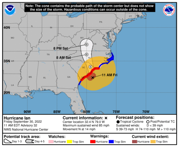
HURRICANE IAN: At 1100 AM EDT, the center of Hurricane Ian was located near latitude 32.4 North, longitude 79.0 West. Ian is moving toward the north near 14 mph. Ian is forecast to move more quickly toward the north today followed by a turn toward the north-northwest by tonight. On the forecast track, the center of Ian will reach the coast of South Carolina today, and then move farther inland across eastern South Carolina and central North Carolina tonight and Saturday.
Maximum sustained winds remain near 85 mph with higher gusts. Ian should maintain about the same strength before landfall later, then weaken and rapidly transition into a post-tropical cyclone overnight. Ian should dissipate over western North Carolina or Virginia late Saturday. Hurricane-force winds extend outward up to 70 miles from the center and tropical-storm-force winds extend outward up to 275 miles. A sustained wind of 62 mph and a gust to 87 mph were recently reported at an elevated WeatherFlow station on Winyah Bay Range in South Carolina. The estimated minimum central pressure is 980 mb (28.94 inches) based on data from NOAA buoy 41004, located about 45 miles southeast of Charleston.
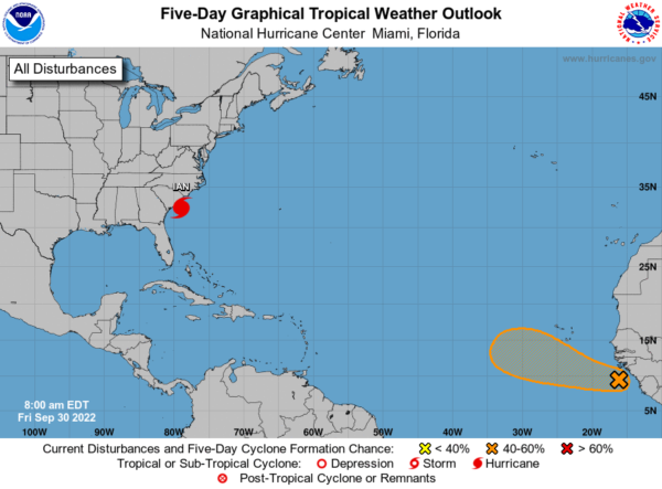
ELSEWHERE IN THE TROPICS: A tropical wave is producing disorganized showers and thunderstorms over the far eastern tropical Atlantic. Environmental conditions are forecast to be conducive for gradual development of this system, and a tropical depression could form early next week as the system moves westward to west-northwestward over the eastern tropical Atlantic. Formation chance through 5 days…medium…60 percent. If this system develops, it would be Julia.
NEXT WEEK: The first week of October will remain dry for Alabama as the delightful fall weather continues. Expect mostly sunny days and fair nights. Highs near 80° each day; lows in the upper 50s and low 60s most mornings. October is statistically Alabama’s driest month, and that looks to hold true this year.
BEACH FORECAST CENTER: Get the latest weather and rip current forecasts for the beaches from Fort Morgan to Panama City on our Beach Forecast Center page. There, you can select the forecast of the region that you are interested in visiting.
WORLD TEMPERATURE EXTREMES: Over the last 24 hours, the highest observation outside the U.S. was 111.2F at Mina, Saudi Arabia. The lowest observation was -98.7F at Vostok, Antarctica.
CONTIGUOUS TEMPERATURE EXTREMES: Over the last 24 hours, the highest observation was 112F at Death Valley, CA. The lowest observation was 21F at Angel Fire, NM.
Category: Alabama's Weather, ALL POSTS
About the Author (Author Profile)
Macon, Georgia Television Chief Meteorologist, Birmingham native, and long time Contributor on AlabamaWX. Stormchaser. I did not choose Weather, it chose Me. College Football Fanatic. @Ryan_StinnetSubscribe
If you enjoyed this article, subscribe to receive more just like it.


