Long Dry Spell To Continue; Ian Is Inland
**No afternoon Weather Briefing weather video this afternoon**
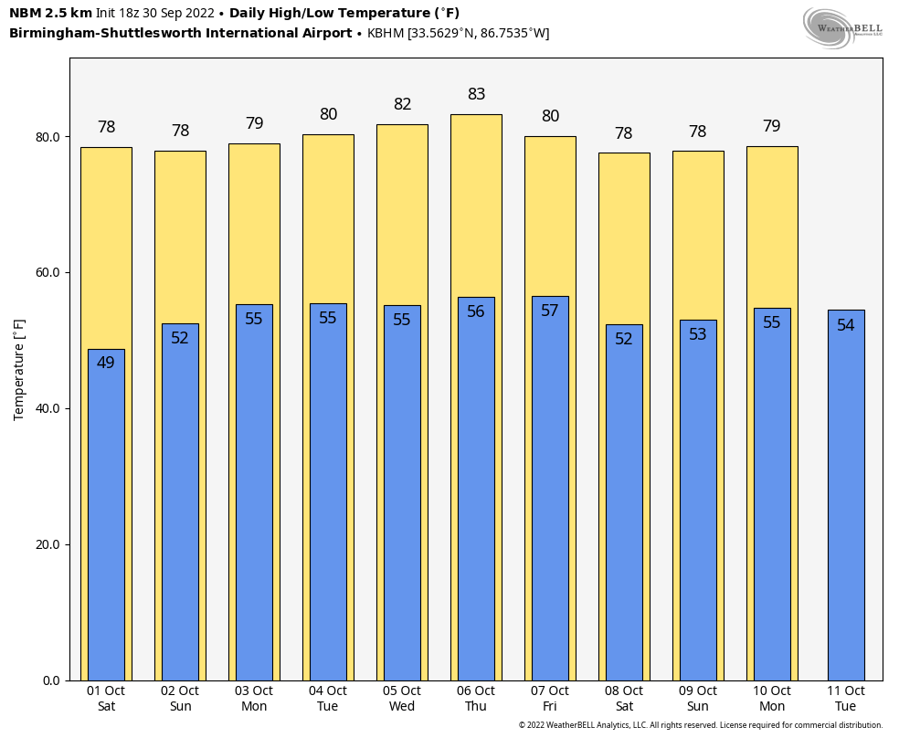
DRY DAYS CONTINUE: Alabama’s weather just won’t change much through next week as the dry conditions continue. Look for sunny pleasant days and clear cool nights; highs will be in the mid to upper 70s through Monday, and in the low 80s by the middle of next week. Lows will be mostly in the 50s. Still no evidence of any serious rain event around here for at least the next ten days.
Keep in mind October is our driest month of the year, so weather like this isn’t too unusual.
TROPICS: Hurricane Ian made landfall this afternoon at 1:05p CT near Georgetown, South Carolina with winds of 85 mph. The system will weaken quickly tonight as it moves inland. Elsewhere, a tropical wave is producing disorganized showers and thunderstorms over the far eastern tropical Atlantic. Environmental conditions are forecast to be conducive for gradual development of this system, and a tropical depression could form early next week as the system moves westward to west-northwestward over the eastern tropical Atlantic. Too early to know if this will be a threat to any land area.
FOOTBALL WEATHER: For the high school games in the state tonight, the sky will be mostly clear with temperatures falling through the 60s.
Tomorrow, Alabama travels to Fayetteville to take on Arkansas (2:30p CT kickoff)… the sky will be sunny with a temperature around 80 degrees as the game begins. No risk of rain.
Auburn hosts LSU tomorrow evening (6:00p CT kickoff) at Jordan-Hare Stadium. The sky will be mostly fair with temperatures falling from near 72 at kickoff, into the 60s during the game.
UAB will be in Houston to take on Rice (6:30p CT kickoff)… the sky will be clear with temperatures falling from the low 80s at kickoff into the mid 70s by the final whistle.
RACE WEEKEND: The weekend looks great for Talladega as Ian stays to the east. Expect a good supply of sunshine tomorrow and Sunday with highs in the mid to upper 70s.
ON THIS DATE IN 1896: A hurricane formed on September 22 and lasted until September 30. It formed directly over the Lesser Antilles and hit Cuba, Florida, Georgia, South and North Carolina, Virginia, Washington D.C., and Pennsylvania. Its maximum sustained winds were at 130 mph. The heaviest rainfall deposited in association with the storm was 19.96 inches at Glennville, Georgia. This hurricane was responsible for an estimated 130 deaths.
BEACH FORECAST: Click here to see the AlabamaWx Beach Forecast Center page.
Look for my next Weather Briefing video here by 6:00 a.m. Monday… enjoy the weekend!
Category: Alabama's Weather, ALL POSTS
About the Author (Author Profile)
James Spann is one of the most recognized and trusted television meteorologists in the industry. He holds the AMS CCM designation and television seals from the AMS and NWA. He is a past winner of the Broadcast Meteorologist of the Year from both professional organizations.Subscribe
If you enjoyed this article, subscribe to receive more just like it.


