Alabama’s Long Dry Spell Continues
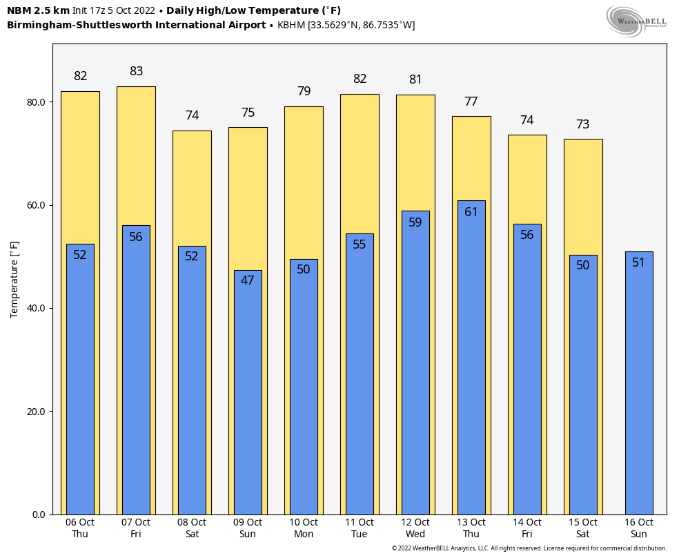
DRY OCTOBER WEATHER: Dry weather is the story for Alabama through the weekend with sunny days and clear nights. Look for highs in the 80-84 degree range tomorrow and Friday, but by Saturday and Sunday highs drop into the mid 70s. Lows will be in the 50s through Saturday morning, but 40s are likely early Sunday, with some potential for upper 30s across the colder valleys of North Alabama.
NEXT WEEK: Still no sign of rain next week; it still looks like the next rain opportunity for Alabama will come in the October 15-20 time frame.
Some notes on the dry conditions (based on data at Birmingham)…
*Today is the 10th consecutive day with no measurable rain.
*Our last measurable rain was on September 25, but the amount was only 0.03″.
*We have gone without measurable rain on 24 of the last 25 days.
*The last day with over one tenth of an inch of rain came on September 4, when the total was 1.55″
FOOTBALL WEATHER: Another delightful evening for high school football games across the state Friday night; the sky will be clear with temperatures falling through the 60s.
Auburn travels to Athens Saturday to take on the Georgia bulldogs (2:30p CT kickoff)… the sky will be sunny; about 77 degrees at kickoff, falling into the low 70s by the final whistle. UAB has a home game in downtown Birmingham Saturday at Protective Stadium against Middle Tennessee (also a 2:30p CT kickoff)… it will be sunny afternoon with temperatures falling from around 75 degrees at kickoff to near 70 by the final whistle.
Then, Saturday night Alabama hosts Texas A&M (7p CT kickoff) at Bryant-Denny Stadium in Tuscaloosa; the sky will be clear with temperatures falling from 67 degrees at kickoff into the 50s by the fourth quarter. A perfect night for football.
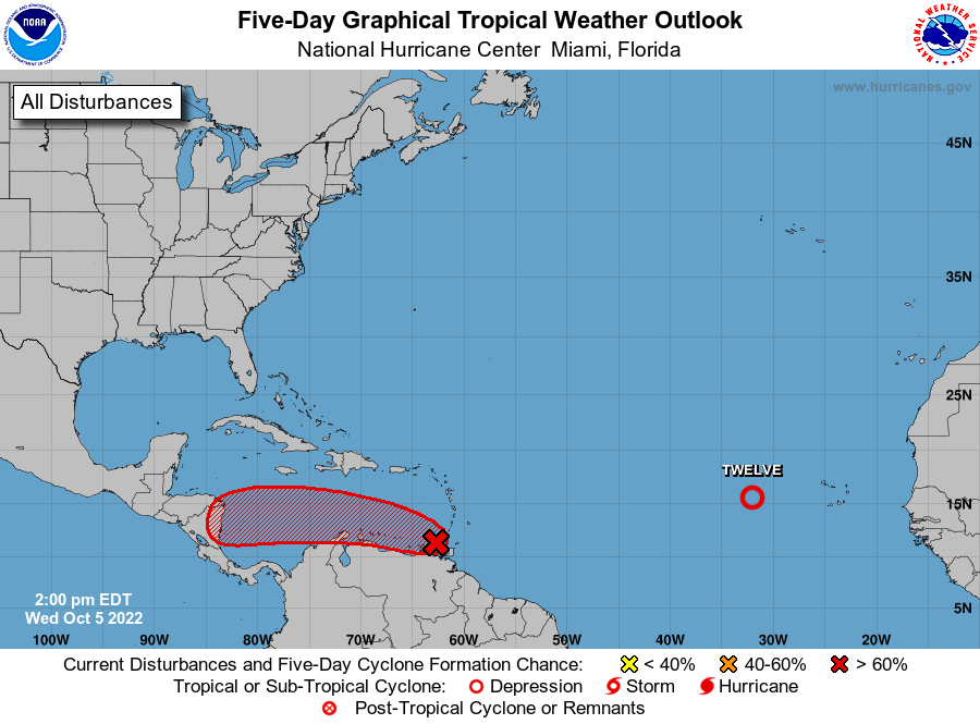
TROPICS: Tropical Depression 12 in the eastern Atlantic is expected to dissipate tonight far from land.
Surface observations and data from an Air Force Reserve reconnaissance aircraft mission this morning indicate that the broad area of low pressure located over the far southeastern Caribbean Sea (Invest 91L) does not have a well-defined center. Although the system is producing a large area of showers and thunderstorms over the southern Windward Islands and adjacent waters, satellite and radar imagery from Barbados show that it is not well organized. The system is forecast to move generally westward near the northern coast of South America, and interaction with land is likely to hinder significant development during the next day or so. After that time, environmental conditions are expected to become more conducive for development, and a tropical depression is likely to form within the next two to three days when the system is over the south-central Caribbean Sea.
Most likely this system is headed for Central America in 5 days or so; it remains to be seen if the remnants will move into the Pacific, or curve northward toward the Bay of Campeche (the far Southwest Gulf of Mexico). Still just something to watch for now.
ON THIS DATE IN 1972: Tropical Storm Joanne, earlier a hurricane, moved across the Baja California peninsula and came ashore in western Mexico south of Ajo. The storm brought heavy rain and flooding to much of Arizona. This storm is the first documented tropical storm to reach Arizona, with its cyclonic circulation intact. Over 5 inches of rain was reported on the Mogollon rim southeast of Flagstaff.
BEACH FORECAST: Click here to see the AlabamaWx Beach Forecast Center page.
Look for the next Weather Briefing video here by 6:00 a.m. tomorrow…
Category: Alabama's Weather, ALL POSTS
About the Author (Author Profile)
James Spann is one of the most recognized and trusted television meteorologists in the industry. He holds the AMS CCM designation and television seals from the AMS and NWA. He is a past winner of the Broadcast Meteorologist of the Year from both professional organizations.Subscribe
If you enjoyed this article, subscribe to receive more just like it.


