Sunday Weather Briefing: Perfection Ahead, Rain for Midweek
Gorgeous day yesterday behind a couple of cold fronts. The day started off with some cloudiness across the Central part of the state, as expected, but bright blue skies quickly ensued. Temperatures started off in the lower 50s across the Tennessee Valley, with a few 40s in the normally colder locations. Middle and upper 50s prevailed across Central Alabama. Afternoon readings stayed pretty close to 70F over the North, with readings ranging from 75-80 degrees across the middle of the state.
CHILLY START: 30s are fairly plentiful across North Alabama early this morning, with middle and upper 40s across Central Alabama. There is likely some light frost in the protected areas up North.
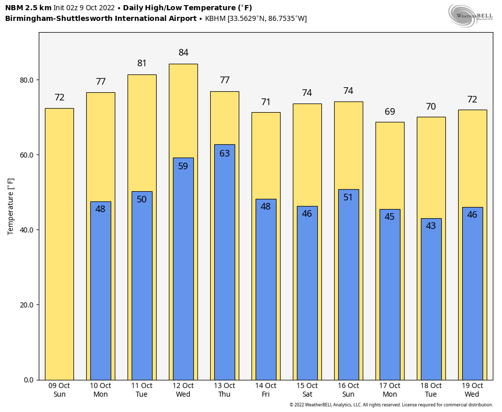
TASTE OF FALL CONTINUES: Another beautiful day is in store for Alabama today. With more brilliant blue skies, highs will top out in the lower 70s North, with middle and upper 70s Central. Lows tonight will be in the 40s mostly. Those normally colder locations could dip into the upper 30s.
NICE START TO THE WORK WEEK: Keeping a close eye on the weather for Monday, We are right in the middle of the threshold for a Perfect Weather Warning. More Robin’s Egg Blue skies, a light northerly wind, dewpoints in the 40s, and highs in the middle and upper 70s. Those conditions check all the boxes for a PWW. All Alabamians are urged to take to the outdoors today. We are monitoring the model data for Tuesday, which is outside the 24-hour lead time, so we will issue a Perfect Weather Watch for Tuesday. Afternoon readings may be a little warm, with highs expected to be in the lower 80s, just beyond the threshold of middle and upper 70s.
MIDWEEK TRANSITION: High pressure that has been in control of Alabama’s weather will shift eastward and allow a southeasterly flow to return by Tuesday afternoon. This will allow humidity levels to rise. By then we will be watching a cold front to our northwest that will be passing through Kansas City by Wednesday morning. That front, accompanied by its attendant deep upper-level trough that will be diving southeast out of Canada, will be getting ready to lift that newly arrived moisture over the Deep South. It looks like showers and some thunder will begin breaking out during the evening of Wednesday, with widespread showers across much of Alabama into much of Thursday. The cold front will sweep through Alabama pretty quickly late in the day on Thursday. Leading to clearing skies and a change back to cooler.
RAINFALL OUTLOOK: Rainfall from the frontal system will average one inch across North and Central Alabama, with isolated amounts of up to 2 inches.
WEEKEND OUTLOOK: Friday will be a breezy and cooler day with a good bit of sunshine and post-frontal stratocumulus clouds. Highs should be around 70F after morning lows in the upper 40s and lower 50s. Saturday should be a gorgeous day, with highs in the middle 70s after morning lows well down into the 40s. Another cold front will pass through the area late Saturday night and Sunday morning. There could be a few showers over Northeast Alabama, but most of the state will remain dry. The airmass behind this front will mean business, with highs in the lower 60s Sunday. Lows will be down into the 40s, and even some 30s dare I say by Monday the 17th.
FLY IN THE OINTMENT: Hurricane Julia made landfall early this morning over eastern Nicaragua north of Bluefields. Top winds at landfall were around 80 mph. 5-10 inches of rain with isolated amounts of up to 15 inches are expected across Nicaragua, which will cause life-threatening flooding and mudslides. It appears that Julia may maintain tropical storm strength as it moves across Central America, and this has necessitated the issuance of tropical storm warnings along the Pacific Coast of Nicaragua, Honduras, and El Salvador for later tonight and Monday.
GULF OF MEXICO MISCHIEF: The GFS has been pulling some of the energy associated with Julia northward into the Bay of Campeche, but that appears to be unlikely.
BEACHCAST: Today, Monday, and Tuesday will be perfect along the beautiful beaches of Alabama and Northwest Florida as well. Showers will return by late Wednesday and Thursday looks wet. Highs will be in the lower and middle 80s all week. Lows will warm back into the 60s by Tuesday. 50s will be prevalent Monday. Water temperatures are still in the middle 70s. The rip current risk will be low into midweek.
Click here to see the Beach Forecast Center page.
NATIONALLY: Freeze Warnings are the only things we are worried about Nationally on this Fall Sunday. They cover parts of eastern Kentucky, southern Ohio, and Western Virginia. Locations in those regions will be some 6-10 degrees below normal when the lows are tallied.
DANCING WITH THE STATS: 22.42 inches of rain at Orlando was a new record there for any September. 13.11 inches fell during Hurricane Ian, of course.
ADVERTISE WITH US: Deliver your message to a highly engaged audience by advertising on the AlabamaWX.com website. The site enjoyed over 29 MILLION page views in the past 12 months. Don’t miss out! We can customize a creative, flexible, and affordable package that will suit your organization’s needs. Contact me, Bill Murray, at (205) 687-0782 and let’s talk.
WEATHERBRAINS: This week, the panel will talk to Allyson Rae, the Chief Meteorologist for WBBH in Fort Myers. She says last week was the worst week in her career. We will commiserate with her and continue to unpack how 119 people could die in Hurricane Ian, making it the deadliest hurricane in Florida since the 1935 Labor Day Hurricane. Check out the show at www.WeatherBrains.com. You can also subscribe on iTunes. It’s now easier than ever to watch the show live at
Category: Alabama's Weather, ALL POSTS, Weather Xtreme Videos


