Dry Air Returns; Much Colder Next Week
SUNNY AFTERNOON: The sky is sunny across Alabama this afternoon with temperatures generally in the 70s; tonight will be clear and cool with a low in the 40s. Colder spots across North Alabama could dip into the upper 30s.
TOMORROW AND THE WEEKEND: Sunny weather continues tomorrow and Saturday with warm afternoons… highs will be in the low 80s both days. A cold front could bring a few isolated showers to the state late Sunday and Sunday night, but moisture will be very limited and rain amounts will be very light and spotty. Otherwise Sunday will feature a partly sunny sky with a high around 80 degrees.
NEXT WEEK: Other than a small risk of a shower Monday morning, the week looks dry and colder. It will be the coldest air so far this season; temperatures won’t get out of the 50s over most of North Alabama Tuesday afternoon, and we expect lows in the 25-35 degree range early Wednesday morning. Many places across North Alabama will see their first freeze of the season and frost is likely deep into South Alabama. See the daily Weather Briefing video for maps, graphics, and more details.
FOOTBALL WEATHER: Another perfect night for high school football games across Alabama tomorrow night; the sky will be clear with temperatures falling from the mid 70s at kickoff into the 60s by the second half.
Saturday Auburn travels to Oxford to play Ole Miss (11a CT kickoff)… the sky will be partly sunny, and there is an outside risk of a passing shower during the game. Temperatures will rise from near 78 at kickoff into the low 80s by the second half.
Alabama will take on Tennessee in Knoxville (2:30p CT kickoff)… the sky will be partly to mostly sunny; about 77 degrees at kickoff, falling to near 70 by the final whistle.
UAB will host Charlotte at Protective Stadium in downtown Birmingham Saturday (2:30p CT kickoff)… expect a mostly sunny sky; about 82 at kickoff, upper 70s by the fourth quarter.
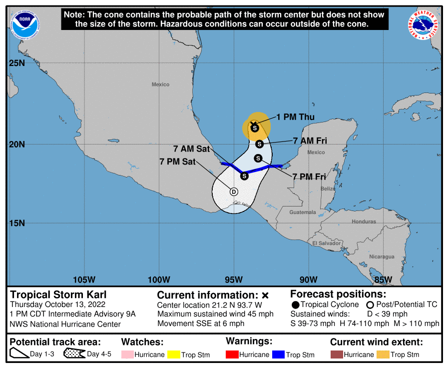
TROPICS: Tropical Storm Karl, with sustained winds of 45 mph this morning, will move into the coast of Mexico far south of Brownsville, Texas tomorrow night.
Elsewhere, a large area of disorganized showers and thunderstorms located several hundred miles south of the Cabo Verde Islands is associated with a tropical wave. Environmental conditions appear marginally favorable for some slow development of this system as it moves westward to west-northwestward at 5 to 10 mph over the tropical Atlantic through early next week.
Only a 20 percent chance of development over the next five days, and the rest of the Atlantic basin is very quiet.
WEDNESDAY’S RAIN: Some rain totals from the past 36 hours across Alabama…
Grove Hill 3.71″
Auburn 2.45″
Alexander City 2.20″
Birmingham Airport 2.03″
Geneva 1.85″
Enterprise 1.71″
Decatur 1.66″
Haleyville 1.48″
Huntsville 1.47″
Calera 1.47″
Montgomery 1.41″
Sylacauga 1.37″
Anniston 1.14″
Muscle Shoals 1.01″
Tuscaloosa 0.89″
Mobile Airport 0.65″
ON THIS DATE IN 2006: The October 2006 Buffalo storm was an unusual early-season lake effect snowstorm that hit the Buffalo, New York area, and other surrounding areas of the United States and Canada. Downtown Buffalo reported 15 inches from this event.
ON THIS DATE IN 2011: Three tornadoes hit central and Eastern Virginia on this day. One of the EF1 tornadoes caused damage to the Sylvania Plantation home that was built in 1746. The storm peeled the roof off the house.
BEACH FORECAST: Click here to see the AlabamaWx Beach Forecast Center page.
Look for the next Weather Briefing video here by 6:00 a.m. tomorrow…
Category: ALL POSTS
About the Author (Author Profile)
James Spann is one of the most recognized and trusted television meteorologists in the industry. He holds the AMS CCM designation and television seals from the AMS and NWA. He is a past winner of the Broadcast Meteorologist of the Year from both professional organizations.Subscribe
If you enjoyed this article, subscribe to receive more just like it.


