Sunday Weather Discussion: A Fairly Dreary Sunday Gives Way to a Splendid Week
Saturday was a wonderful day across North and Central Alabama. We enjoyed a gorgeous orange-colored landscape brought to us by sunrise, dappled sunshine through the morning, some clouds, a few showers over West Alabama, mild afternoon readings, and a fresh southerly breeze. We watched storms back to the southwest over Louisiana and Mississippi that became severe ahead of a surface low. Those storms got into Southwest Alabama and Southeast Mississippi late yesterday afternoon and early last evening. Damage was reported near Foley and in the Oyster Bay and Gulf Shores areas of Baldwin County, where a mobile home was destroyed. Several impressive waterspouts were observed over Mobile Bay.
RAINY SUNDAY MORNING: The surface low is near Little Rock, and it has become occluded (a fancy way of saying that the cold front caught up with the warm front in the weakening system.) Areas north and east of I-22/US-280 are in the 50s, while the rest of the area is in the 60s to begin the day. A secondary surface low will likely form over West Central Alabama this morning and a narrow sliver of a warm sector may work across southern portions of the area. So you can expect a high chance of rain, especially through the morning hours, There could be a few rumbles of thunder, but you shouldn’t expect any severe weather today. It will be breezy much of today with southeasterly winds gusting to above 20 mph at times. Clouds will be pretty thick across much of the area, although some clearing will work into western sections later this afternoon in places like Livingston, Butler, Jackson, and Mobile in Southwest Alabama. Highs will generally be in the lower and middle 70s, except over Northwest Alabama where readings may not get out of the upper 60s.
ALL HALLOWS’ EVE: Skies may be slow to clear on Monday, Halloween, with a lot of moisture left lying around. There could be a few showers left over during the day as well, but most of that should be in Georgia by late in the day. Highs will struggle to get out of the 60s unless the sun makes more of an appearance than I am thinking. Everything points to fabulous weather for trick-or-treating Monday night. Temperatures will retreat into the upper 50s by 9 p.m., but skies should be partly cloudy and winds should be light by then.
SAYING GOODBYE TO OCTOBER: October will coast to a mild and seasonal ending tomorrow night. For the month, temperatures will end up at a mean of around 61.3F, which is about three and a half degrees below the normal mean of 64.9. The highest temperature in the month was 84F on the 7th. The coldest mornings were the 19th and 20th when the mercury fell to freezing. Before this current system, we had recorded 2.10 inches of rain in the month, spread over three days. If we pick up another .60 today, we will finish the month around 2.70 inches, which is a little below the average of 2.99 inches.
AND HELLO TO NOVEMBER: November is the transition month to winter across much of the country, and Alabama is no exception. The days are approaching their shortest of the year, and the heat budget is becoming increasingly negative, so average temperatures are dropping. The storm track is becoming more active and precipitation totals are increasing. There is a secondary severe weather season in November in Alabama that in some recent years has been busier than the spring primary season. In 2002, an unusually strong outbreak on November 10th produced a series of ten tornadoes across North Alabama that killed 12. Two of the tornadoes were rated F3.
According to the long term averages from 1991-2020, 4.23 inches of rain falls in the month. The most ever observed is 15.25 inches in 1948. The most snow ever observed in November was 1.4 inches in 1950. At the start of the month, the average high is 70 degrees. It will fall to 61 degrees by month’s end. The normal monthly high is 65.0F. In November 1931, the normal high was 72.4F, the warmest November on record. It has been as warm as 85F, in 1998, 2000 and 2003. Average lows start off at 46 degrees, and fall to 38 by month’s end. The average low is 43.0. The coldest average low was in the cold winter of 1976-77, when the November average low was 33.8F. In the eleventh month, it has been as cold as 5F, back on November 25, 1950. The next coldest reading was 8 degrees higher…on November 24, 1970.
The sky is cloudy 33 percent of the time. The sky is clear 31 percent of the time. Only October averages more clear sky time in the Magic City. Dense fog is observed on one day in the month on average.
BEAUTIFUL WEEK AHEAD: Just get ready for gorgeous weather the rest of the week. There could be a light shower or two early Wednesday, but they will be inconsequential. Highs will be in the lower to middle 70s and lows will be in the lower 50s. Just a little above normal for this time of year, but no one will be complaining.
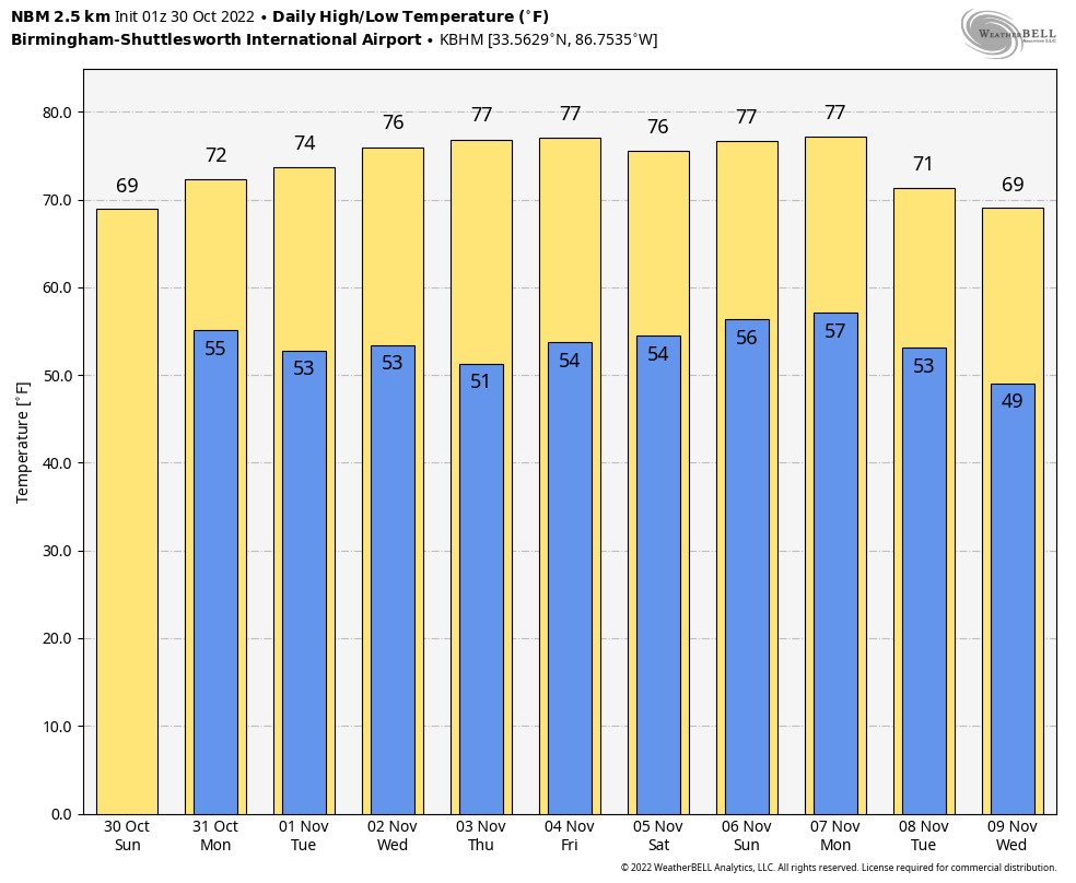
WEEKEND SNEAK PEEK: The weekend looks beautiful as well with high pressure in charge. Highs will be in the middle 70s with lows in the lower 50s.
TROPICS: The disturbance over the Central Caribbean has a fairly good chance of developing into a tropical depression and perhaps a tropical storm over the next couple of days. It should not amount to much and steam westward toward the Yucatan, staying out of the Gulf. A big surge of cold air is moving northward across South America, and this powerful cold front looks like it could be the source area for something to spin up over the southwestern Caribbean by next weekend. That system could be interesting as it could impact Cuba, the Bahamas, and possibly the southeastern U.S. in week two. Something to watch.
IN THE WESTERN PACIFIC: The Philippines have been hit by deadly floods and landslides from Tropical Storm Nalgae. At least 42 people are dead after heavy rains struck southern portions of the country upon Tropical Storm Nalgae’s approach. The storm is expected to move northwest over the next few days, further impacting the Philippines this weekend, then Taiwan and southeastern China this week.
BEACHCAST: Enjoyed a fabulous weekend at Alabama’s Gulf State Park last week with some beautiful weather and thinner crowds than you encounter in the summer. Now that all of yesterday’s bad weather is moving out, expect beautiful conditions along our beaches as well. The forecast calls for partly cloudy skies each day Monday through Sunday with few if any showers. Highs will warm to near 80F. Lows will be in the lower 60s. Water temperatures are in the lower 60s. There will be a high risk of rip currents today.
Click here to see the Beach Forecast Center page.
ADVERTISE WITH US: Deliver your message to a highly engaged audience by advertising on the AlabamaWX.com website. The site enjoyed over 29 MILLION page views in the past 12 months. Don’t miss out! We can customize a creative, flexible, and affordable package that will suit your organization’s needs. Contact me, Bill Murray, at (205) 687-0782 and let’s talk.
WEATHERBRAINS: This week, the panel will entertain Dustin Jordan from the NWS in Jackson, Kentucky. His office had responsibility for all of the severe flooding that hit the eastern part of the Bluegrass State earlier this year. . Check out the show at www.WeatherBrains.com. You can also subscribe on iTunes. It’s now easier than ever to watch the show live at . You will be able to see the show on the James Spann 24×7 weather channel on cable or directly over the air on the dot 2 feed.
ON THIS DATE IN 1991: On this Halloween Eve, a major coastal storm was born off the East Coast. A cold front moving offshore met up with Hurricane Gracie and one of the worst nor’easters the East Coast has ever seen was born. The major low-pressure system batters New England with high winds and tides of 4-7 feet above normal. Winds had been gusting to 50 mph along the coast for a couple of days and tides were already high when the storm moved in from the east. Major coastal flooding and beach erosion resulted. Over 1000 homes were damaged or destroyed. Winds reached hurricane force at Chatham and Gloucester MA. Waves offshore were reported to be as high as 63 feet! Damage totaled $200 million. 33 people died. Follow my weather history tweets on Twitter. I am @wxhistorian at Twitter.com.
Category: Alabama's Weather, ALL POSTS, Tropical
About the Author (Author Profile)
Bill Murray is the President of The Weather Factory. He is the site's official weather historian and a weekend forecaster. He also anchors the site's severe weather coverage. Bill Murray is the proud holder of National Weather Association Digital Seal #0001 @wxhistorianSubscribe
If you enjoyed this article, subscribe to receive more just like it.


