Late Morning Nowcast: Increasing Clouds, Rain Returns Tonight
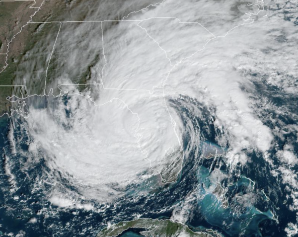
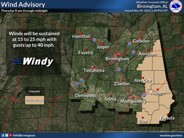
Nicole made landfall as a hurricane overnight, now as tropical storm, Nicole continues a northwestward track across Florida, and will make a turn northward later today, heading into Southwest Georgia. Our forecast the rest of today will feature increasing clouds and we should begin to see rain push into southeast Alabama over the next few hours. Wind and rain will spread into the eastern 2/3 of the state tonight, with rain amounts of 1-2 inches possible over our far eastern counties.
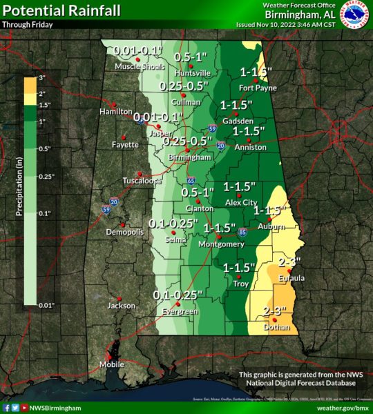
Communities over far West Alabama will see little to no rain. Winds will also increase, gusts in the 40/45 mph range are likely over East Alabama this afternoon, and a Wind Advisory has been issued for these areas.
No risk of severe storms or tornadoes since we are well west of the center of circulation. The tornado threat is over Georgia and the Carolinas. Tomorrow, the rain will end from the south tomorrow, expect a mostly cloudy and breezy day with a high in the mid 60s.
NICOLE UPDATE: The center of Tropical Storm Nicole was located near latitude 28.2 North, longitude 82.2 West. Nicole is moving toward the west-northwest near 16 mph. A turn toward the northwest and north-northwest is expected later today, followed by a turn toward the north tonight. Nicole is expected to accelerate north-northeastward on Friday. On the forecast track, the center of Nicole will continue to move across the west central Florida peninsula this morning and emerge over the far northeastern Gulf of Mexico this afternoon. The center should then move across the Florida Panhandle and Georgia tonight, and then move through the southeastern United States on Friday.
Maximum sustained winds are have decreased to near 50 mph with higher gusts. Additional weakening is expected this morning while the center is over land. Little change in strength is expected while Nicole is over the Gulf of Mexico this afternoon and evening. Nicole is expected to weaken to a depression over Georgia tonight, and then it is expected to merge with a frontal boundary over the Mid-Atlantic United States by Friday night. Nicole remains a large tropical storm. Tropical-storm-force winds extend outward up to 345 miles from the center, especially to the northeast. The estimated minimum central pressure from surface observation is 985 mb (29.09 inches).
FRIDAY NIGHT LIGHTS: The weather will be dry for the high school playoff games tomorrow night across Alabama, but it will be mostly cloudy and breezy with temperatures falling into the 50s.
COLD WEEKEND: Much colder air moves into Alabama on the backside of the departing tropical system east of Alabama. This will be the coldest air so far this season as highs drop into the 50s Saturday and Sunday. Temperatures will drop into the upper 20s to lower 30s by Sunday morning. Some North Alabama communities might not get out of the 40s Sunday as the cold air continues to settle into the state. Saturday will be mostly cloudy with a few spotty showers, and a brisk northerly wind. Sunday will be dry and sunny.
FOOTBALL FORECAST: Saturday, Alabama travels to Oxford to take on Ole Miss (2:30p CT kickoff)… the sky will be mostly sunny with temperatures in the mid to upper 40s along with a brisk, chilly north wind.
UAB will host North Texas at Protective Stadium in downtown Birmingham Saturday (2:30p CT kickoff)… the sky will be mostly cloudy with a kickoff temperature around 52 degrees, falling into the 40s by the final whistle. Some rain is likely in Birmingham Saturday morning, but it will be over by the time the game begins.
Auburn hosts Texas A&M Saturday evening at Jordan-Hare Stadium (6:30p CT kickoff). The sky will be mostly fair with temperatures falling from near 47 at kickoff, into the low 40s by the final whistle.
NEXT WEEK: Another freeze is likely early Monday morning…the day will be dry with a high in the 50s Monday afternoon. Clouds increase Monday night, and global models bring rain a disturbance into the state Tuesday with a good chance of rain at times. Then, the weather looks dry Wednesday through Friday with temperatures remaining below average…highs in the 50s and lows in the 30s and 40s.
BEACH FORECAST CENTER: Get the latest weather and rip current forecasts for the beaches from Fort Morgan to Panama City on our Beach Forecast Center page. There, you can select the forecast of the region that you are interested in visiting.
WORLD TEMPERATURE EXTREMES: Over the last 24 hours, the highest observation outside the U.S. was 108.3F at Lajamanu, Australia. The lowest observation was -71.5F at Vostok, Antarctica.
CONTIGUOUS TEMPERATURE EXTREMES: Over the last 24 hours, the highest observation was 95F at Rio Grande Village, TX. The lowest observation was -20F at Choteau, MT.
Category: Alabama's Weather, ALL POSTS
About the Author (Author Profile)
Macon, Georgia Television Chief Meteorologist, Birmingham native, and long time Contributor on AlabamaWX. Stormchaser. I did not choose Weather, it chose Me. College Football Fanatic. @Ryan_StinnetSubscribe
If you enjoyed this article, subscribe to receive more just like it.


