Radar Check at 10:30 p.m.
A large band of precipitation is moving eastward across Alabama and the Florida Panhandle tonight.
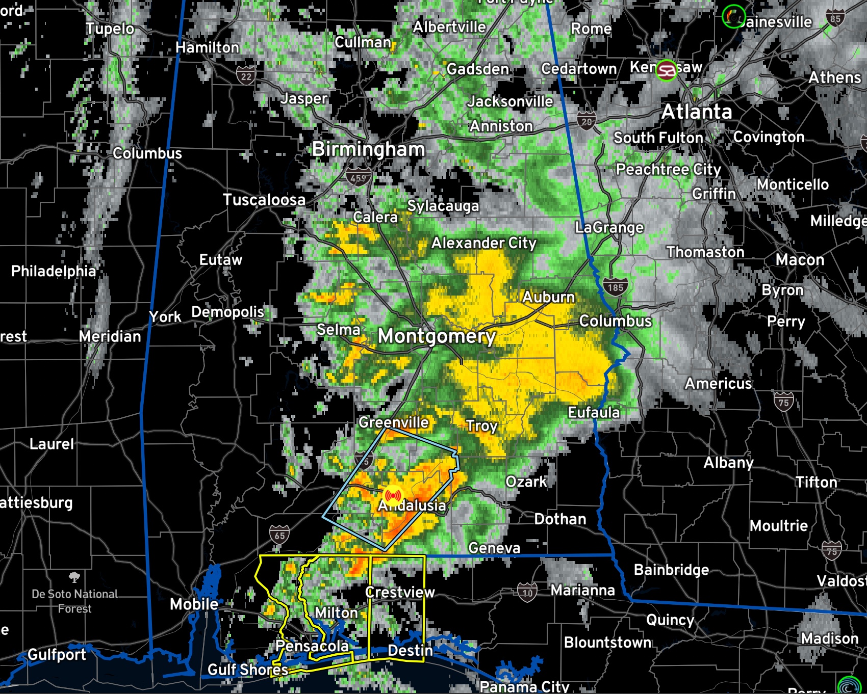
Across North and Central Alabama, it is only rain. Heavy rain and storms cover much of the southern half of Alabama, south of US-80. The heaviest rain and storms are now south of Montgomery. There has been a good bit of lightning associated with these storms, but they have weakened a bit. It is moving northeast, parallel to I-65.
There are no warnings in effect now, but severe weather is possible through the overnight hours.
A tornado watch remains in effect until midnight for Escambia, Okaloosa, and Santa Rosa counties in Florida.
The storms across South Central Alabama are elevated, or not rooted near the surface because the surface-based instability in out over the Gulf of Mexico. The surface-based instability may be able to work onshore over the Panhandle over the next few hours as a weak low level jet pumps warmth and moisture northward.
The surface low is back over southern Missouri now. It will move northeast into Illinois by morning. By then, the cold front will be all the way out of Alabama. The showers should be out of the state by then as well.
Winds are gusty across Alabama, out of the southeast averaging 8-16 mph and gusting to 20-25 mph. A Wind Advisory remains in effect for all of North, Central, and much of South Alabama.
Clearing will occur quickly behind the cold front. Winds will remain gusty through the overnight and into Sunday morning, which will prevent fog formation. Low clouds will fill back in during the morning over the northern third of Alabama.
Morning lows will be in the 40s over Northwest Alabama, but 50s elsewhere. Sunday highs will be in the 50s over the northwestern corner of the state, with 60s across the rest of the area. Clouds may edge a little further south Sunday afternoon and evening, perhaps reaching I-20. Fog will form in areas that stay clear.
Winds will die down Sunday night, allowing fog to form in areas that don’t see low clouds. Overnight lows will be in the 40s.
Monday will feature partly cloudy skies with highs in the 60s. Clouds will increase on Tuesday and it will continue to be mild. Tuesday highs will try to approach 70F, especially over southern regions. Rain and storms will return to Alabama Tuesday night. There will be a chance of severe weather to the west of Alabama, but the instability should be waning as the storms roll into our state. Rain and thunder will continue into Wednesday.
Rain may hold off until the end of the first week of December, thanks to a fesity subtropical ridge across the Gulf Coast states. A quick hitting series of storms may affect Alabama and the Deep South out at the end of the forecast period, between the 8th and 13th.
Temperatures will be mild that first week of December, with daytime highs in the 70s. No really cold weather is in sight for Alabama.
Category: Alabama's Weather, ALL POSTS
About the Author (Author Profile)
Bill Murray is the President of The Weather Factory. He is the site's official weather historian and a weekend forecaster. He also anchors the site's severe weather coverage. Bill Murray is the proud holder of National Weather Association Digital Seal #0001 @wxhistorianSubscribe
If you enjoyed this article, subscribe to receive more just like it.


