Sunday Weather Briefing: Storms Return Tuesday Night into Wednesday
Saturday was a mild, breezy, and wet affair across Alabama. Winds averaged some 8-16 mph, gusting to 20-25 mph. Rain and storms moved into the state at late afternoon, and pushed eastward across the state during the evening and overnight. Some gusts to near 40 mph were observed. A tornado watch was in effect for Mobile and Baldwin counties in Alabama, as well as counties in Northwest Florida
FOR YOUR SUNDAY: The cold front is pushing eastward out of the state this morning, taking the precipitation with it. Skies will clear fairly quickly, except over North Alabama. Winds will remain gusty through the morning hours, but will be diminishing gradually. They will die down overnight, allowing some fog to form in areas that clear. Morning lows will be in the 40s over Northwest Alabama, but 50s elsewhere. Sunday highs will be in the 50s over the northwestern corner of the state, with 60s across the rest of the area. Clouds may edge a little further south Sunday afternoon and evening, perhaps reaching I-20. Fog will form in areas that stay clear. Overnight lows will be in the 40s.
FIRST PART OF THE WEEK: Monday will feature partly cloudy skies with highs in the 60s. Clouds will increase on Tuesday and it will continue to be mild. Tuesday highs will try to approach 70F, especially over southern regions. Rain and storms will return to Alabama Tuesday night. There will be a chance of severe weather to the west of Alabama, but the instability should be waning as the storms roll into our state. Rain and thunder will continue into Wednesday, diminishing during the afternoon. Thursday will feature much cooler conditions, with highs barely making it out o the 40s. Expect a fairly rapid warmup heading into the weekend.
DRY WEATHER: Rain may hold off until the end of the first week of December, thanks to a feisty subtropical ridge across the Gulf Coast states. Temperatures will approach the 70s during the first week of December.
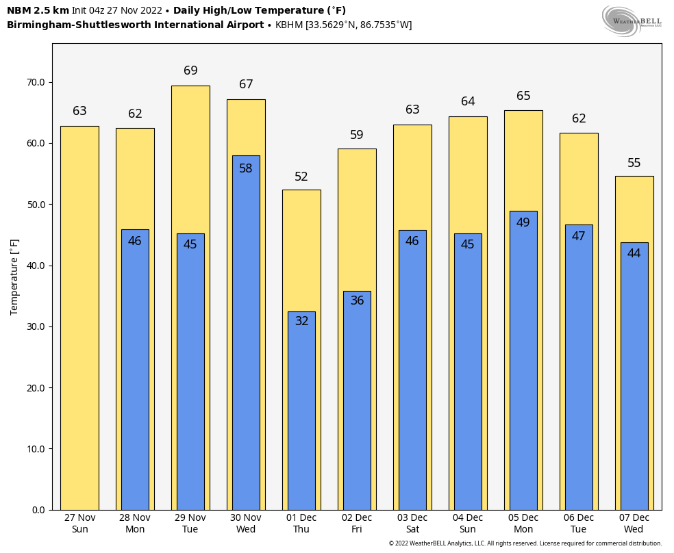
VOODOO TERRITORY: A quick-hitting series of storms may affect Alabama and the Deep South out at the end of the forecast period, between the 8th and 13th. Temperatures will be mild that first week of December, with daytime highs in the 70s. No really cold weather is in sight for Alabama.
BEACHCAST: Rain moved out quickly this morning, but will return late Tuesday into Wednesday. Highs will be in the lower 70s Monday through Wednesday, falling back into the 60s behind another cold front and round of storms. Water temperatures are near 60F. The rip current risk will be high today and tonight, but will calm Monday before increasing again on Tuesday and Wednesday.
Click here to see the Beach Forecast Center page.
WEATHERBRAINS: This week, the panel will entertain Friend of the Podcast Paul Schlatter from the NWS Boulder, Colorado. Check out the show at www.WeatherBrains.com. You can also subscribe on iTunes. You can watch the show live at live.bigbrainsmedia.com or on James’ YouTube Channel You will be able to see the show on the James Spann 24×7 weather channel on cable or directly over the air on the dot 2 feed.
ON THIS DATE IN 1912: Snow actually fell in northern Florida, the only time that has happened in November in recorded history. One-half inch of snow was reported at Mt. Pleasant. Traces were also recorded at Marianna, Tallahassee, and Blountstown.
Category: Alabama's Weather, ALL POSTS
About the Author (Author Profile)
Bill Murray is the President of The Weather Factory. He is the site's official weather historian and a weekend forecaster. He also anchors the site's severe weather coverage. Bill Murray is the proud holder of National Weather Association Digital Seal #0001 @wxhistorianSubscribe
If you enjoyed this article, subscribe to receive more just like it.


