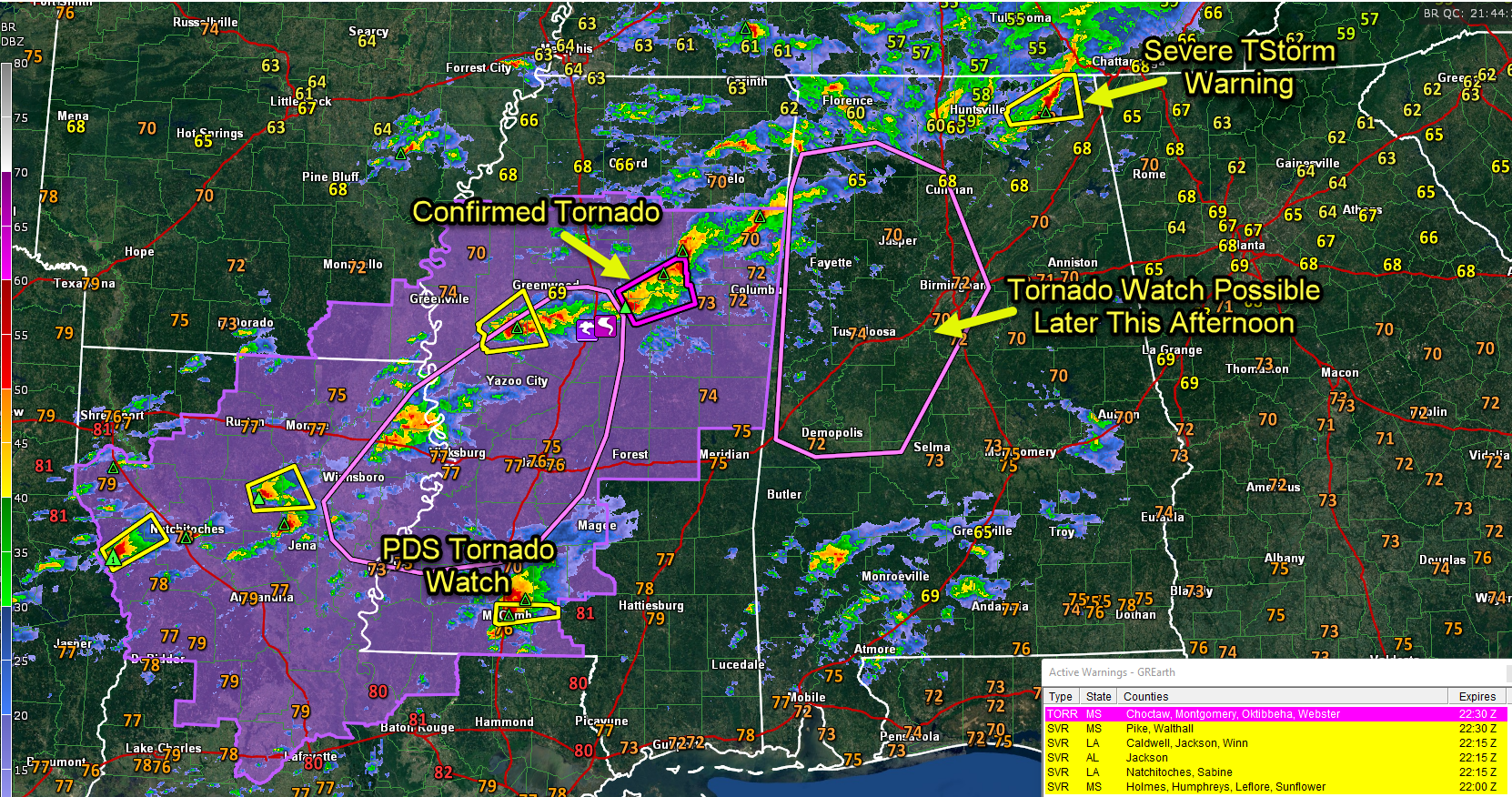
Big Picture at 4 pm: Tornado Watch Will be Needed for Parts of Central Alabama in Next Couple of Hours
Severe weather continues across the South this afternoon and will peak over the next few hours.
Four main areas of action right now…
TENNESSEE VALLEY OF NORTH ALABAMA
A severe thunderstorm warning is in effect for Jackson County in Northeast Alabama. A wind gust of 56 mph was recorded at the Huntsville International Airport at 2:38 pm. A flash flood warning remains in effect for Colbert, Franklin, and Lauderdale counties.
SOUTHWEST ALABAMA
Storms that develop in a strongly sheared environment here have a chance of becoming severe. Conditions will become more favorable for severe weather here later and a watch may be required this evening.
SOUTHEAST TEXAS
Hail and gusty winds are the main threat, but a tornado warning has been in effect for areas east of St. Augustin, west of Natchitoches. The NWS in Shreveport has issued a severe thunderstorm warning for the downstream areas ahead of the storm.
CENTRAL MISSISSIPPI
This is the key corridor for severe weather over the next few hours. With the PDS watch in effect, and several confirmed tornado warnings in Mississippi, the main threat will continue for several hours. Temperatures are in the upper 70s with dewpoints in the upper 60s to lower 70s, resulting in STP values of 3-4. There is strong low level shear of 250 m2/s2. The strongest storm is approaching Eupora. A tornado was reported near West in Attalla County. This will be passing northwest of Starkville MS. The campus at Mississippi State is shuting down activities at 4 p.m.
Now for Central Alabama…
A tornado watch is likely for areas west of I-65 in Central Alabama over the next couple of hours. The tornadic storms in North Central Mississippi will move into west-central Alabama between 430 and 445 pm and will train across the area through the evening and overnight hours.
The tornado threat will increase for folks in Northwest Alabama from Marion and Winston and Lamar counties between 430 and 7 p.m.
Folks in Sumter, Green, Pickens, and Tuscaloosa will see their tornado threat increase in the 7-9 pm time frame.
Storms may reach the Birmingham area between 10 and 11 pm but the tornado threat should be a little lower then.
I am most concerned about the I-20 Corridor during the 9 pm – 3 am time frame when storms access the best instability and shear from Lamar/Pickens/Sumter/Greene Counties eastward through Fayette, Walker, Tuscaloosa, Hale, Jefferson, Shelby, Bibb, and Chilton counties. This will be the time period with the greatest severe weather threat for these counties, including the threat of tornadoes.
It’s not to late to make your severe weather plan if you don’t have one. If you do, take time to review it with your family. Let friends and family know about the threat.
Category: Alabama's Weather, ALL POSTS, Severe Weather
About the Author (Author Profile)
Bill Murray is the President of The Weather Factory. He is the site's official weather historian and a weekend forecaster. He also anchors the site's severe weather coverage. Bill Murray is the proud holder of National Weather Association Digital Seal #0001 @wxhistorianSubscribe
If you enjoyed this article, subscribe to receive more just like it.


