Midday Nowcast: Mild with More Clouds Than Sun
With an upper ridge over the Gulf of Mexico, our weather will continue to feature unseasonably warm temperatures and the risk of scattered showers on a daily basis, nothing especially heavy or widespread. Temperatures this afternoon are generally in the 60s, with 70s expected statewide tomorrow and Thursday. Locations over south Alabama will likely see some low 80s this week.
ACROSS THE USA: Heavy rain in the Mid-South could produce flash flooding. Rain will expand over the Lower and Central Mississippi Valley and across the Mid-Atlantic and Northeast through mid-week. Accumulating snow continues in the northern tier and 4-Corners. Pacific Northwest mountain and low elevation snow returns mid-week.
END OF WEEK FRONT: A cold front will bring the risk of scattered showers Friday and highs hold in the 70s, thankfully severe storms are not expected. Then, for the weekend, highs will drop back into the 60s. We should see more clouds than sun both days, and for the most part it will be dry, but there will remain the risk for a few scattered showers.
NEXT WEEK: While a few scattered showers are possible Monday and Tuesday, the rain will be more widespread Wednesday, along with the chance of a few thunderstorms. Cooler, drier air returns Thursday and Friday. Highs will be in the 60s for the first half of the week, then dropping into the 50s by Thursday.
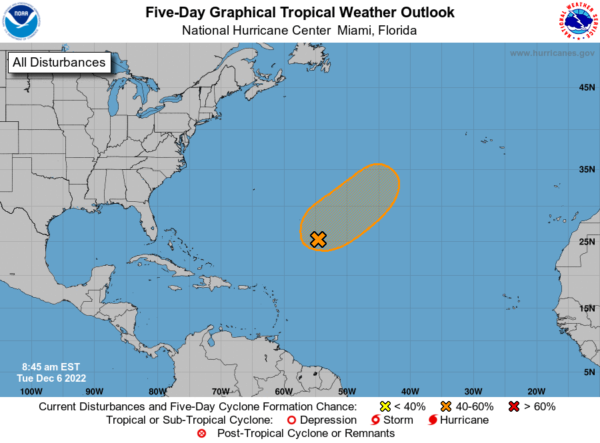
IN THE TROPICS: A large area of low pressure located over the central subtropical Atlantic about 800 miles northeast of the northern Leeward Islands continues to produce a broad area of showers and thunderstorms. Environmental conditions appear marginally conducive for development and a subtropical or tropical storm could form in the next couple of days. By Thursday night or Friday, the low will move northeastward over cooler waters and interact with a mid-latitude trough, limiting subtropical or tropical development of the system. Additional information on this low, including warnings, can be found in High Seas Forecasts issued by the National Weather Service. Formation chance through 5 days…medium…50 percent.
BEACH FORECAST CENTER: Get the latest weather and rip current forecasts for the beaches from Fort Morgan to Panama City on our Beach Forecast Center page. There, you can select the forecast of the region that you are interested in visiting.
WORLD TEMPERATURE EXTREMES: Over the last 24 hours, the highest observation outside the U.S. was 114.3F at Marble Bar, Australia. The lowest observation was -71.0F at Delyankir, Russia.
Category: Alabama's Weather, ALL POSTS
About the Author (Author Profile)
Macon, Georgia Television Chief Meteorologist, Birmingham native, and long time Contributor on AlabamaWX. Stormchaser. I did not choose Weather, it chose Me. College Football Fanatic. @Ryan_StinnetSubscribe
If you enjoyed this article, subscribe to receive more just like it.


