Midday Nowcast: Mainly Cloudy and Very Warm
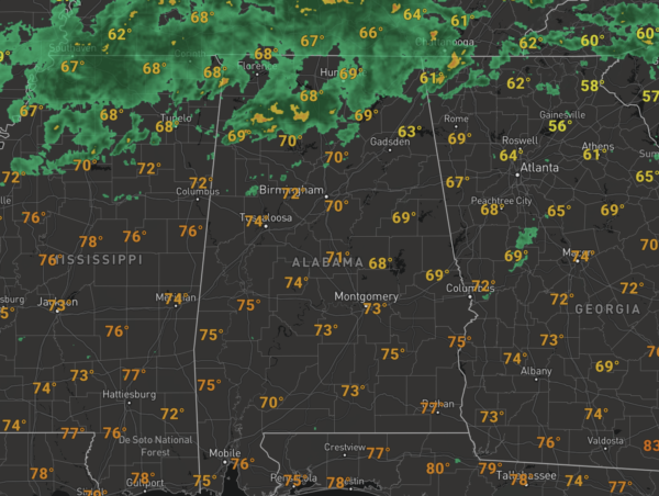
Temperatures are surging into the 70s this afternoon, and these are about 15 degrees above average for this time of year. We continue to see areas of scattered showers, and these will continue the rest of today, but it won’t rain everywhere, and most of the activity will remain over the northern third of the state, closer to the surface boundary. More of the same tomorrow with more clouds, a few showers, and very warm December temperatures as mid and upper 70s will persist. In fact, places across South Alabama are seeing 80s this week.
FRIDAY FRONT: A cold front will bring the risk of scattered showers back to the rest of the state Friday, highs hold in the 70s, thankfully severe storms are not expected.
WEEKEND WEATHER: The front struggles to sink south through Alabama this weekend, meaning more clouds than sun with the threat of scattered showers both days. Highs Saturday will be closer to 70°, but drop back into the mid 60s Sunday.
NEXT WEEK: Warm temperatures and some scattered showers are possible Monday and Tuesday. West of Alabama, the SPC has defined a risk of severe storms from North Texas and Oklahoma to Arkansas, Louisiana, and parts of Mississippi early in the week, but they do not have Alabama in a risk at this point at mid-week. The system arrives here Wednesday with rain and thunderstorms… the best dynamic support will stay well to the north, and instability values look low. So, for now the severe weather threat in Alabama looks very limited, but understand this is a week out, and things could change. As this system exits, colder, drier air returns Thursday and Friday with highs in the 50s and lows in the 30s.
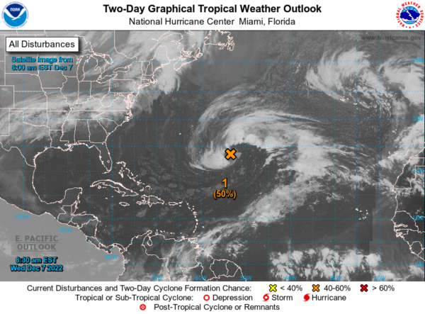
IN THE TROPICS: A large non-tropical area of low pressure located over the central subtropical Atlantic about 900 miles northeast of the northern Leeward Islands continues to produce a large area of showers and thunderstorms. This activity has become somewhat better organized this morning, though frontal features remain attached to the low. Environmental conditions appear marginally conducive for development and a subtropical or tropical storm could form within the next day or so. By Friday, the low will move northeastward over cooler waters and interact with a mid-latitude trough, limiting the chance for additional subtropical or tropical development of the system. Formation chance through 5 days…medium…50 percent.
BEACH FORECAST CENTER: Get the latest weather and rip current forecasts for the beaches from Fort Morgan to Panama City on our Beach Forecast Center page. There, you can select the forecast of the region that you are interested in visiting.
WORLD TEMPERATURE EXTREMES: Over the last 24 hours, the highest observation outside the U.S. was 115.2F at Marble Bar, Australia. The lowest observation was -66.3F at Delyankir, Russia.
CONTIGUOUS TEMPERATURE EXTREMES: Over the last 24 hours, the highest observation was 89F at Falcon Lake, TX. The lowest observation was -36F at Crosby, ND.
Category: Alabama's Weather, ALL POSTS
About the Author (Author Profile)
Macon, Georgia Television Chief Meteorologist, Birmingham native, and long time Contributor on AlabamaWX. Stormchaser. I did not choose Weather, it chose Me. College Football Fanatic. @Ryan_StinnetSubscribe
If you enjoyed this article, subscribe to receive more just like it.


