A Quick Severe Weather Update for Wednesday
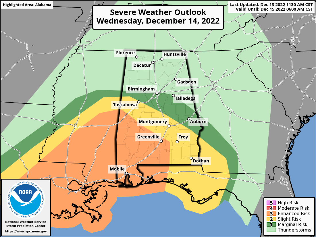
The Storm Prediction Center continues to have an Enhanced Risk up for a good portion of the southwestern quarter of Alabama during the time period of Wednesday 6 am to Thursday 6 am.
That Enhanced Risk includes locations along and south of a line from Gainesville (Sumter Co.) to Orrville (Dallas Co.) to Fort Deposit (Lowndes Co.).
A Slight Risk is up outside of the enhanced risk to as far north as a line from Reform (Pickens Co.) to Clanton (Chilton Co.) to Hurtsboro (Russell co.).
A Marginal Risk is up outside of the slight risk to as far north as a line from Kennedy (Lamar Co.) to the Birmingham Airport (Jefferson Co.) to Talladega (Talladega Co.) to Valley (Chambers Co.).
Tornadoes and damaging winds up to 60 mph will be the threats possible in the severe risk locations, with the main window for the threat of severe storms occurring from roughly 12 pm Wednesday to 2 am Thursday from west to east. In the Enhanced Risk locations, there is the potential of a stronger tornado occurring, ranging from EF-2 to EF-5 in strength.
We’ll have to remember that storms do not follow the lines on a map or a graphic, and severe storms could occur to the north of the Marginal Risk locations, and a stronger tornado could occur in the Slight and Marginal Risk locations, even though that will be highly unlikely.
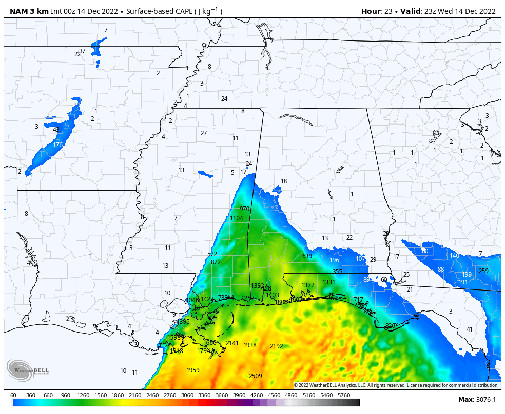
The latest run of the NAM shows the highest levels of instability not moving into the area until around the evening rush hour at 5 pm on Wednesday evening, with elevated values at or above 1,000 J/kg over the southern portions of Sumter and Marengo counties. All of that instability will be moving eastward throughout the evening, which looks to line up nicely with the SPC severe weather risk areas.
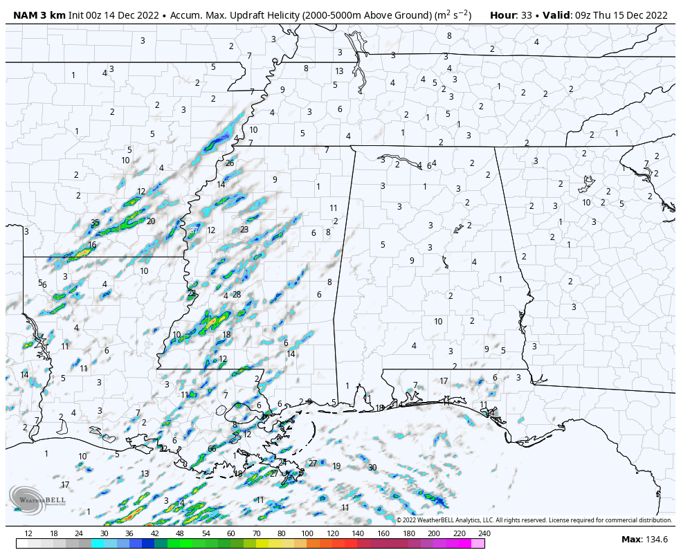
The good news at this point is that we are not seeing very many updraft helicity tracks in this latest run, which means it is possible that the risk of thunderstorms with strong updrafts look to be a little less. This could lead to the reduction of the tornado and damaging wind risk. This is just one run, and we’ll have to see how conditions are as the storms move into the area.
Always have a reliable way of receiving severe weather warnings if they are issued. Never rely on an outdoor siren. Have a plan of action ready to go if your location goes under a warning. Also, have safety gear and supplies ready to go in your safe place.
Remember… tornado season in Central Alabama runs from November to May. Stay weather aware and be prepared!
Category: Alabama's Weather, ALL POSTS, Severe Weather
About the Author (Author Profile)
Scott Martin is an operational meteorologist, professional graphic artist, musician, husband, and father. Not only is Scott a member of the National Weather Association, but he is also the Central Alabama Chapter of the NWA president. Scott is also the co-founder of Racecast Weather, which provides forecasts for many racing series across the USA. He also supplies forecasts for the BassMaster Elite Series events including the BassMaster Classic.Subscribe
If you enjoyed this article, subscribe to receive more just like it.


