Moderate Risk Condensed While Other Risks Expanded Northeastward
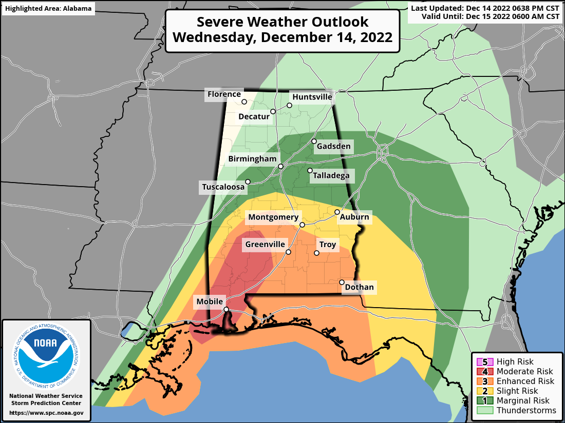
MODERATE RISK – Along and south of a line from Sweet Water (Marengo Co.) to Tilden (Dallas Co.) and down into South Alabama.
ENHANCED RISK – Along and south of a line from Myrtlewood (Marengo Co.) to just south of Marion (Perry Co.) to Autaugaville (Autauga Co.) to Pleasant Hill (Barbour Co.).
SLIGHT RISK – Along and south of a line from Bellamy (Sumter Co.) to Centreville (Bibb Co.) to just north of Opelika (Lee Co.).
MARGINAL RISK – Along and south of a line from just north of Cuba (Sumter Co.) to Hanceville (Cullman Co.) to Cedar Bluff (Cherokee Co.).
Here is the text from the SPC’s latest Day One Severe Weather Outlook update:
A potential for strong tornadoes and damaging thunderstorm winds will continue this evening across parts of far southern Mississippi, southern Alabama and the Florida Panhandle.
The latest WSR-88D radar imagery from Mobile, Alabama shows a band of organized convection, with several embedded tornadic supercells, extending from far southern Mississippi across southwest Alabama. Ahead of the convection, a relatively undisturbed airmass is in place with surface dewpoints in the upper 60s to near 70 F. As a result, moderate instability is present with MLCAPE estimated by the RAP in the 1000 to 1500 J/kg range. In addition, the RAP is analyzing a 50 to 60 knot low-level jet along this same corridor. The Mobile WSR-88D VWP is sampling the jet with a long and looped hodograph. The VWP has 0-3 km storm relative helicity near 475 m2/s2 and 0-6 km shear at 65 knots. This will continue to be favorable for supercells and tornadoes.
The greatest tornado threat will exist over the next few hours from Mobile northward across much of southwest Alabama, where a significant tornado may occur. Several tornadoes will still be possible with rotating cells embedded in the line, and with bow echoes. However, as the band of storms moves eastward across the remainder of southern Alabama and into the Florida Panhandle later this evening, the tornado threat should begin a downtrend.
In addition to the tornado threat, wind damage will also be possible mainly with bowing segments along the leading edge of the line. The severe threat will affect areas of central Alabama this evening, but should be more isolated with northward extent. Also, southwest Georgia should be impacted with an isolated wind-damage and tornado threat later tonight as the line of storms continues to move eastward.
Category: Alabama's Weather, ALL POSTS, Severe Weather
About the Author (Author Profile)
Scott Martin is an operational meteorologist, professional graphic artist, musician, husband, and father. Not only is Scott a member of the National Weather Association, but he is also the Central Alabama Chapter of the NWA president. Scott is also the co-founder of Racecast Weather, which provides forecasts for many racing series across the USA. He also supplies forecasts for the BassMaster Elite Series events including the BassMaster Classic.Subscribe
If you enjoyed this article, subscribe to receive more just like it.


