Saturday Briefing — Mainly Dry & Cool This Weekend; Big Cold Blast by Friday
THIS WEEKEND
Your Saturday will start off mostly cloudy, but much of that cloud cover will move out before sunset. While most areas will be dry, I can’t rule out some sprinkles or a light shower along and south of a line from Demopolis to Clanton to Roanoke. Morning lows in the lower 30s to the lower 40s, with afternoon highs in the mid 40s to the lower 50s.
High pressure will be just off to our west on Sunday which will bring sunny skies and colder temperatures to the area. Lows in the lower 20s to the lower 30s with afternoon highs in the lower 40s to the lower 50s.
NEXT WEEK
Clouds will be on the increase on Monday and there will be a chance of a few showers by afternoon with those chances increasing late through the late-night and into the overnight hours. Morning lows in the mid to upper 20s, with afternoon highs in the upper 40s to the mid 50s.
A small chance of showers will continue on Tuesday with those chances dissipating completely by the late-night hours. Morning lows in the mid to upper 30s for most, with afternoon highs in the upper 40s to the mid 50s.
Wednesday will be a little milder across portions of the area with a mix of sun and clouds. Morning lows in the 30s, with afternoon highs in the upper 40s to the upper 50s.
A strong arctic cold front will begin to move through Central Alabama on Thursday that will bring much colder temperatures and another chance of showers. Those chances look to persist throughout the remainder of the day. The GFS is actually painting some snow flurries for the northern half of the area during the evening through the overnight hours, but there has not really been any consistency with these runs this far out, so we’ll just keep it as a small chance of a few flurries. Morning lows in the lower 30s to the lower 40s, with afternoon highs in the lower 40s to the mid 50s.
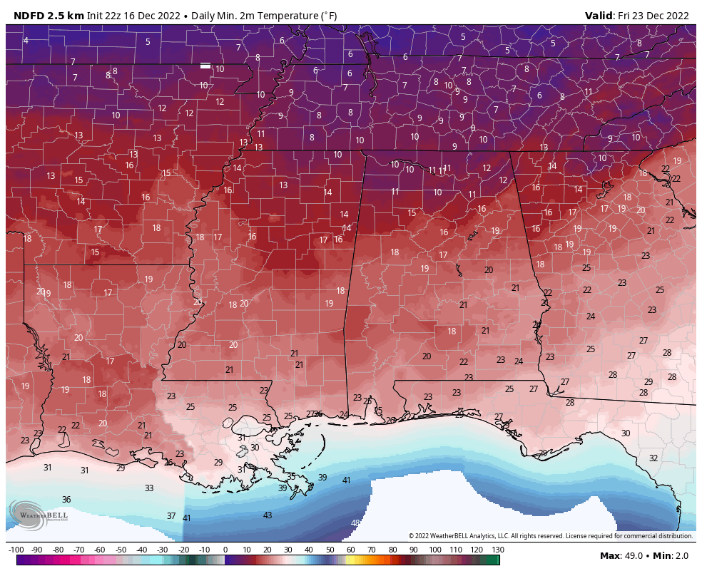
And at the end of the forecast period on Friday… The Arctic Blast will have moved in to the area as some locations will not make it above the freezing mark throughout the day, even with mostly sunny skies. Morning lows in the lower 10s to the lower 20s, with afternoon highs in the mid 20s to the upper 30s.
MERRY CHRISTMAS
Just stepping out into Voodoo Land a little to look at Christmas Eve and Christmas Day… Lows on both days will be in the 10s and 20s with highs in the 30s to the lower 40s. For now, we look to be dry.
Category: Alabama's Weather, ALL POSTS, Weather Xtreme Videos, Winter Weather
About the Author (Author Profile)
Scott Martin is an operational meteorologist, professional graphic artist, musician, husband, and father. Not only is Scott a member of the National Weather Association, but he is also the Central Alabama Chapter of the NWA president. Scott is also the co-founder of Racecast Weather, which provides forecasts for many racing series across the USA. He also supplies forecasts for the BassMaster Elite Series events including the BassMaster Classic.Subscribe
If you enjoyed this article, subscribe to receive more just like it.


