Hard Freeze Warning Issued, Along With Wind Chill Advisories & Warnings
For the locations in North Alabama (Colbert, Cullman, DeKalb, Franklin, Jackson, Lauderdale, Lawrence, Limestone, Madison, Marshall, and Morgan counties), there are no changes in the watches and warnings that are in effect at this point; however, there will most likely be extensions to those products later on.
There is also a very small window of a brief wintry mix falling over those counties followed by a 1-3 hour window of flurries to light snow. Gusty winds will keep any travel impacts from occurring, and only light accumulations in grassy areas up to 0.5 inches may occur. For those on the south and eastern sides of Wheeler Lake, some lake-effect snow may occur that could lead to some accumulations up to 1 inch, but at this point, confidence is not too high.
Now… here is the latest for Central Alabama…
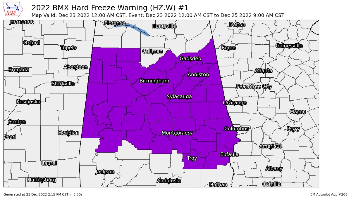
NWS Birmingham has issued a HARD FREEZE WARNING valid from 12 am on Friday to 9 am Sunday for the following counties in Central Alabama: Autauga, Barbour, Bibb, Blount, Bullock, Calhoun, Chambers, Cherokee, Chilton, Clay, Cleburne, Coosa, Dallas, Elmore, Etowah, Fayette, Greene, Hale, Jefferson, Lamar, Lee, Lowndes, Macon, Marengo, Marion, Montgomery, Perry, Pickens, Pike, Randolph, Russell, Shelby, St. Clair, Sumter, Talladega, Tallapoosa, Tuscaloosa, Walker, and Winston.
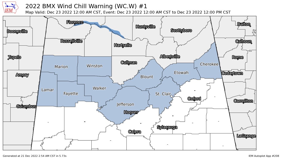
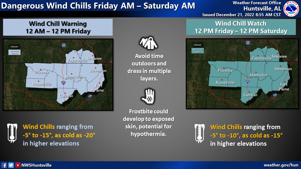
A WIND CHILL WARNING has been issued from 12 am Friday until 12 pm Friday for the following counties in Central Alabama: Blount, Cherokee, Etowah, Fayette, Jefferson, Lamar, Marion, St. Clair, Walker, and Winston.
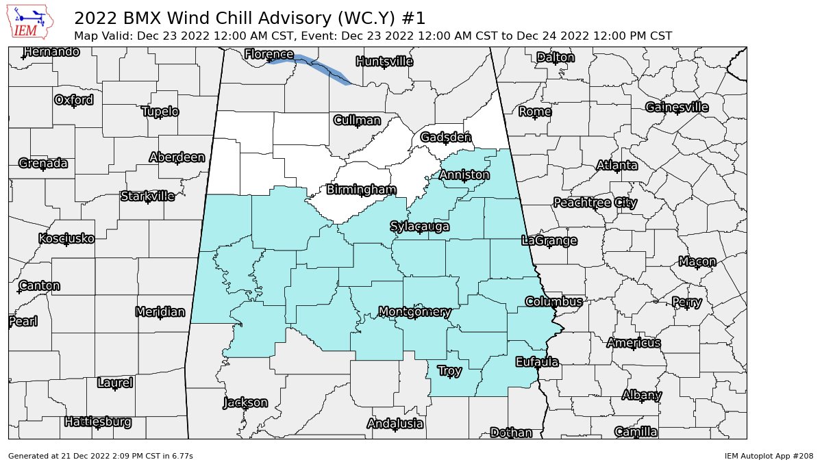
A WIND CHILL ADVISORY has been issued from 12 am Friday until 12 pm Saturday for the following counties in Central Alabama: Autauga, Bibb, Calhoun, Chambers, Chilton, Clay, Cleburne, Coosa, Dallas, Elmore, Greene, Hale, Lee, Lowndes, Macon, Marengo, Montgomery, Perry, Pickens, Randolph, Shelby, Sumter, Talladega, Tallapoosa, and Tuscaloosa.
Sub-freezing temperatures as low as 5 to 12 will be possible in northern portions of Central Alabama. Temperatures as low as 10 to 15 will be possible in southern portions of Central Alabama. Temperatures remain below freezing from late Thursday night until at least midday Sunday. Far northern portions of Central Alabama may remain below freezing until Monday.
Dangerously cold wind chills as low as -5º to -20º are expected as winds will be breezy at times up to 35 mph. The extremely low wind chills could result in hypothermia if precautions are not taken.
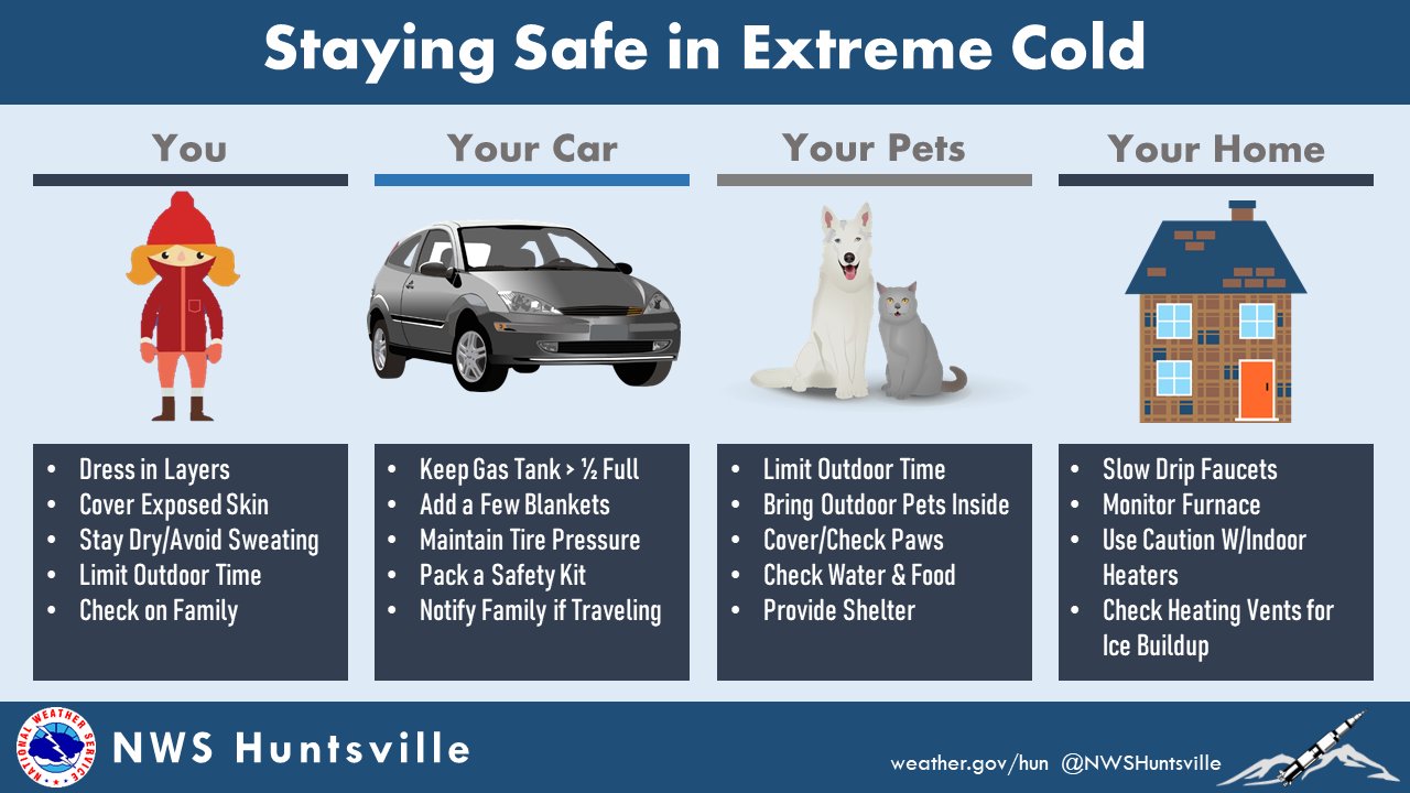
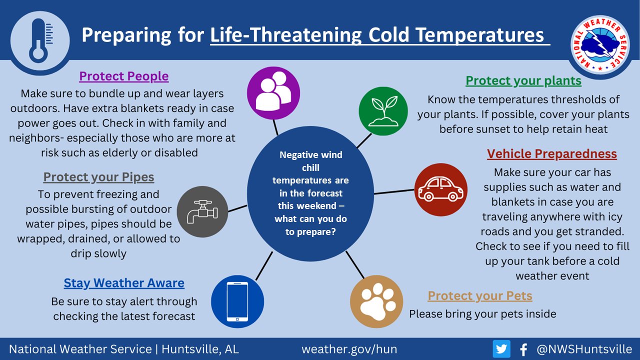
A prolonged period of subfreezing temperatures may cause pipes to burst. Bitterly cold temperatures and wind chills will result in hypothermia or frostbite and become life-threatening to those with prolonged exposure or without access to adequate warmth.
Take steps to ensure people and animals have access to adequate warmth. Ensure that space heaters or other alternative heating sources are at least three feet from anything flammable, are not left unattended, and have sufficient ventilation to prevent carbon monoxide poisoning. If you are traveling make sure you have an emergency supply kit in your car.
Take steps now to protect tender plants from the cold. To prevent freezing and possible bursting of water pipes they should be wrapped, drained, or allowed to drip slowly. Those that have in-ground sprinkler systems should drain them and cover above-ground pipes to protect them from freezing.
Category: Alabama's Weather, ALL POSTS, Winter Weather
About the Author (Author Profile)
Scott Martin is an operational meteorologist, professional graphic artist, musician, husband, and father. Not only is Scott a member of the National Weather Association, but he is also the Central Alabama Chapter of the NWA president. Scott is also the co-founder of Racecast Weather, which provides forecasts for many racing series across the USA. He also supplies forecasts for the BassMaster Elite Series events including the BassMaster Classic.Subscribe
If you enjoyed this article, subscribe to receive more just like it.


