Christmas Morning Weather Briefing: One More Night in the Teens
Merry Christmas to all of you on this frosty Christmas morning. We have to endure one more day of extreme cold as hard freeze warnings continue through tomorrow morning. But we will be above normal as far as temperatures go by late in the week.
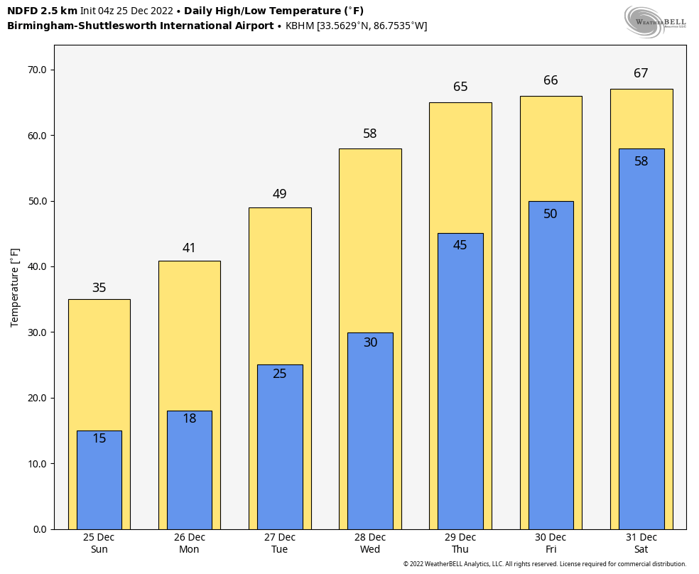
ON THE WEATHER MAPS THIS MORNING: Santa had a nice tailwind on his route into Alabama this morning as a strong Jetstream set up overnight from the Central Plains down through the Arklatex and into Alabama. That roller coaster is the back side of the huge trough over the East. There is an equally impressive ridge over the West. Disturbances passing through this trough are bringing a few clouds to the northern half of the state this morning, but they won’t blot out the sunshine. Expect partly cloudy skies and diminishing winds this morning, as temperatures struggle through to get above freezing this morning. That struggle will be in vain across the Tennessee Valley of North Alabama, where the mercury will remain in the lower 30s all day. Central Alabama won’t be much better, with highs in the middle and upper 30s. With clear, calm conditions tonight, lows will be back in the teens area-wide, ranging from 12F at Scottsboro to 18F at Auburn.
THE WEEK AHEAD: One more night in the teens again tonight, so Monday will dawn bright and cold. The Hard Freeze Warnings will finally expire morrow morning, but breezy winds will keep wind chill values in the teens early. Beyond that, expect increasing clouds during the day with high temperatures between 37-44. There could be a passing snow flurry associated with an upper-level disturbance, but the better chance will be to the north of Alabama. High pressure will be in charge by Tuesday, with highs in the 40s for the most part after another chilly start. Wednesday will see the temperature switch flip dramatically from below normal to above normal as a return southerly flow is re-established. With a good supply of sunshine, highs will return to the 50s, with a 60F reading possible across South Central Alabama. Those southeasterly winds will become gusty at times. Thursday will be dry and warmer still, with gusty winds continuing. Highs will be in the 60s. Morning lows will be interesting, with 30s in eastern sections, and 40s over West Alabama.
NEW YEARS’ WEEKEND: The high-pressure ridge that will be protecting us through midweek will begin to break down on Friday, which will allow for increasing clouds, and a few showers could enter western Alabama as well on Friday. Highs will be in the 60s after morning lows between 42-50F. Rain and thunderstorms will be likely for Saturday, and New Years’ Eve celebrations look wet, unfortunately. Severe weather does not look likely, but I wouldn’t put it past Mother Nature given that James will be trying to finish his vacation peacefully. The weather should move out by Sunday setting the stage for a nice start to the following week.
VOODOO TERRITORY: Looks like a glancing shot of rain on the evening of the 3rd with a stronger system on the 5th.
BEACHCAST: The week will be mostly sunny to partly cloudy through Thursday when the return moisture makes its way back to the coast and a few showers show up. Rain and thunderstorms will be likely Friday and Saturday. The rain should be gone by Sunday and won’t return until the following weekend. Highs will start out in the 40s today, move to the 50s tomorrow then be in the 60s Tuesday and Wednesday. 70s will return for the weekend. Lows will be in the 20s tomorrow, 30s and 40s for midweek, and 60s by the weekend. Water temperatures are in the lower 50s. Perfect for polar bears.
Click here to see the Beach Forecast Center page.
NATIONALLY: Things are relatively quiet this Christmas Day 2022. Snows are still affecting the Great Lakes from the big storm system in eastern Canada. There are snows in the northern Rockies as well. A big storm system will be crashing onshore in the Pacific Northwest early in the week.
DANCING WITH THE STATS: Several coldest high temperatures were set on Saturday across the Southeast. It was 30F at Augusta GA, breaking the previous mark by 6 degrees. The high at Knoxville was 22F, which is two degrees below the previous record.
WEATHERBRAINS: This week, the panel entertained Dr. David Schultz, who is at the University of Manchester. He has studied the link between weather and chronic pain. Tune in and learn whether your grandma’s bunions and corns can predict the weather. Check out the show at www.WeatherBrains.com. You can also subscribe on iTunes. You can watch the show live at live.bigbrainsmedia.com or on James’ YouTube Channel You will be able to see the show on the James Spann 24×7 weather channel on cable or directly over the air on the dot 2 feed.
ON THIS DATE IN 1974: Tropical Cyclone Tracy blasted Darwin, Australia with 150 mph winds, damaging or destroying nearly 90 percent of the city’s buildings. Tracy would be the worst cyclone ever to hit Australia 47 people died in the storm. Because Darwin seemed to be protected by an offshore island, planners did not expect the city would ever experience really high winds. Early on Christmas Eve, Tracy made an abrupt 90-degree turn past Melville Island and steamed right into Darwin. Residents were unconcerned about the storm and went on with their holiday festivities. The storm raged through the pre-dawn hours, with the eye passing directly over Darwin at about 4 am. Many residents were caught outside when the lull passed. Follow my weather history tweets on Twitter. I am @wxhistorian at Twitter.com.
Category: Alabama's Weather, ALL POSTS, Weather Xtreme Videos
About the Author (Author Profile)
Bill Murray is the President of The Weather Factory. He is the site's official weather historian and a weekend forecaster. He also anchors the site's severe weather coverage. Bill Murray is the proud holder of National Weather Association Digital Seal #0001 @wxhistorianSubscribe
If you enjoyed this article, subscribe to receive more just like it.


