Wednesday’s Weather Briefing Video — The Warm Up Continues Before the Weekend Rain
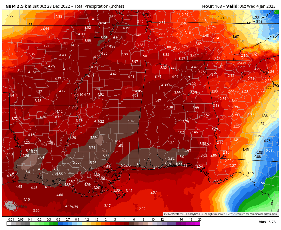
Projected rainfall totals through the end of this forecast period on Tuesday night.
TODAY: After a cold start to the day today, temperatures will make a nice recovery as ridging starts to take over the weather pattern across Central Alabama. Skies will be mainly sunny for most, but a few clouds may move in over the southern portions. Highs in the mid 50s to the mid 60s.
END OF THE WORK WEEK: Thursday will be another day with warmer temperatures as warm air advection continues ahead of the next developing system off to our west. Skies will be mostly sunny during the daylight hours, but clouds will start to slowly increase during the evening. Highs in the lower 60s to the lower 70s.
Much of the day on Friday looks to remain dry across much of Central Alabama, but a warm front moving northward through the southern portions of the area will bring rain with it during the afternoon and evening hours. Rain will be likely with some embedded thunder during the evening and overnight hours for all the area. Highs in the lower 60s to the lower 70s.
THE NEW YEAR’S WEEKEND: While it will be mild on New Year’s Eve, unfortunately the day will start off with rain and some thunder. However, models are now trending drier for the evening and late-night hours, and we should be dry for the ringing in of the 2023. Highs in the mid 60s to the lower 70s.
New Year’s Day is looking fantastic as that system departs, and we’ll have mostly sunny skies through the day. A few clouds will start to move in late ahead of another impulse. Highs in the mid 60s to the lower 70s.
THE FIRST WORK WEEK OF 2023: Unfortunately, rain looks to be with us for much of this first full week of the new year. Showers will become possible early on Monday ahead of a building cold front, and rain chances will increase through the day. Highs in the mid 60s to the lower 70s.
And at the end of the forecast period on Tuesday… Rain and storms will be likely over the western parts of the area by midday as the front approaches and slowly begins its slow trek through the area. Rain will be heavy at times, and we may see some minor flooding issues. Highs in the mid 60s to the lower 70s. Unfortunately, rain looks to stick around through the pre-dawn hours on Thursday morning.
Category: Alabama's Weather, ALL POSTS, Weather Xtreme Videos
About the Author (Author Profile)
Scott Martin is an operational meteorologist, professional graphic artist, musician, husband, and father. Not only is Scott a member of the National Weather Association, but he is also the Central Alabama Chapter of the NWA president. Scott is also the co-founder of Racecast Weather, which provides forecasts for many racing series across the USA. He also supplies forecasts for the BassMaster Elite Series events including the BassMaster Classic.Subscribe
If you enjoyed this article, subscribe to receive more just like it.


