

Thursday Weather Briefing Video — A Few Sprinkles Today; Rain Moves in Tomorrow
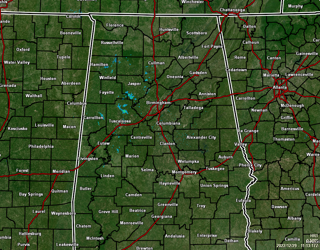
Radar at 5:13 am showed a few pockets of sprinkles out there over the northwestern parts of the area, mainly north of I-20/59 and west of I-65. As far as rainfall for today, that should be all we see as the rest of the area should remain dry with a mix of sun and clouds. Highs in the lower 60s to the lower 70s.
A frontal system will approach the area on Friday that will bring rain and some thunder to the western parts as early as midday, and will slowly move eastward into the rest of Central Alabama. Rainfall totals for the day will range from 0.25 in to around 1.00 in from northeast to southwest. Highs in the lower 60s to the lower 70s.
The daylight hours on New Year’s Eve look to be stormy as the front continues to move through and eventually exiting the area by late afternoon. Rainfall totals through the day will range from 0.25 in to 1.25 in from west to east. The good news is that the evening now looks to be dry and should have no issues for the ringing in of the new year. Highs in the lower 60s to the lower 70s.
New Year’s Day will nearly be a perfect weather day across Central Alabama. Skies will mostly sunny with highs in the mid 60s to the mid 70s.
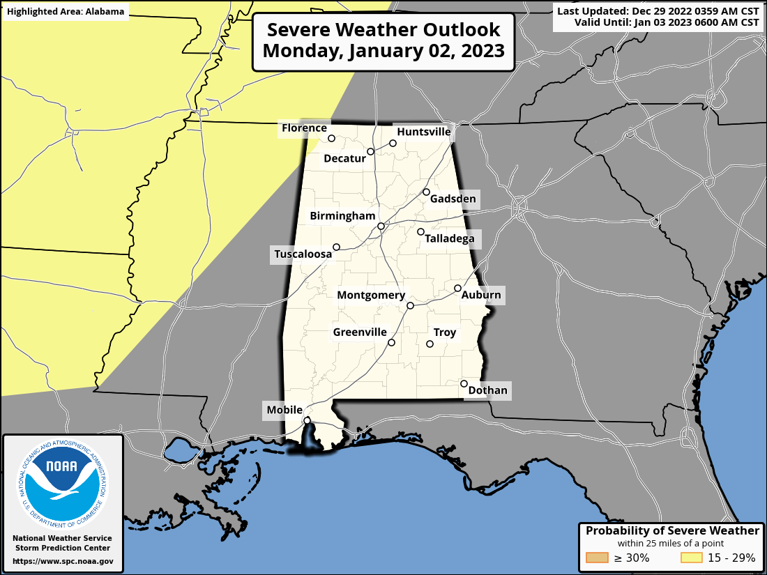
Next week will start off as a wet and stormy one. Another system will slowly move into the area on Monday that will bring the chance of rain and thunderstorms. For now, rain chances look to move into the area just before midday and will continue through the remainder of the day. We may have a strong storm or two late, but as for now, the risk of severe weather stays mainly to our west. The SPC does have a Slight Risk up on their day five graphic out to the west, and it clips the northwest corner of the Tennessee Valley Region. Rainfall totals look to be 0.50 in or less. Highs in the upper 60s to the mid 70s.
Tuesday will be a very wet day as the system continues to move into the area. Rain will be heavy at times, and we could see a few flooding issues arise as rainfall totals for the day look to be around 1.50 in to 2.50 in. At this point, severe storms look unlikely, but I couldn’t rule out a strong storm or two. Highs in the mid 60s to the lower 70s.
And at the end of the forecast period on Wednesday… Rain and storms will continue through the morning hours, but the activity will finally push out of the area by the late afternoon. Before it leaves, we could see another 0.25 to 2.5 inches of rainfall from northwest to southeast, and flooding issues will continue to be possible. Highs in the upper 50s to the upper 60s. The good news is that the rest of the work week is trending dry.
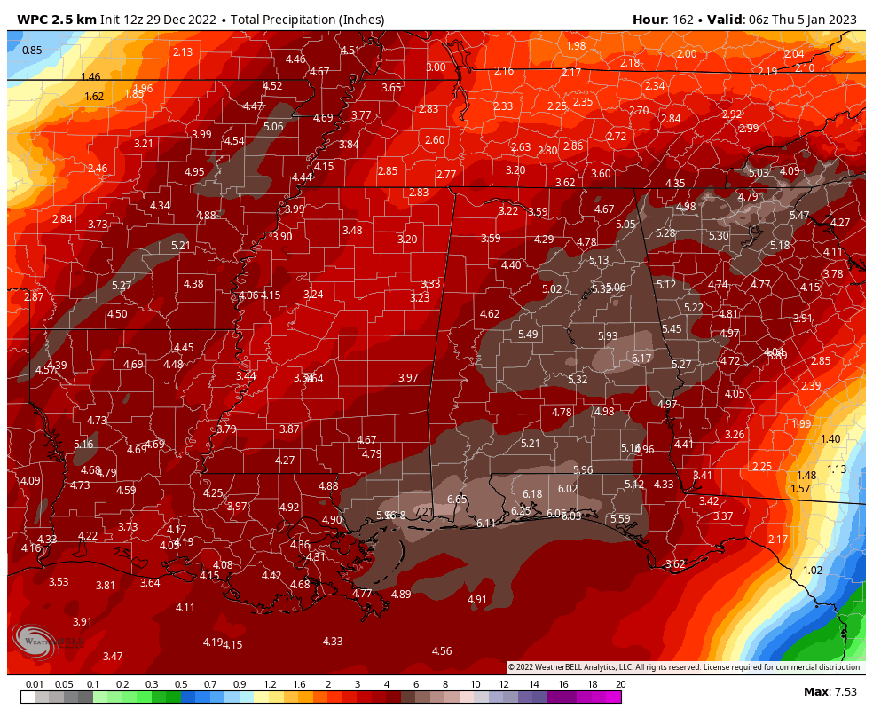
Rainfall totals by midnight on Wednesday may reach as high as 3.25 in to 6.25 in across the area. They could see as high as over 7.00 inches down near the Gulf Coast. Please, keep an eye out for flood advisories and warnings this week, and do not attempt to drive on flooded streets. Turn around, don’t drown!
Category: Alabama's Weather, ALL POSTS, Severe Weather, Weather Xtreme Videos
About the Author (Author Profile)
Scott Martin is an operational meteorologist, professional graphic artist, musician, husband, and father. Not only is Scott a member of the National Weather Association, but he is also the Central Alabama Chapter of the NWA president. Scott is also the co-founder of Racecast Weather, which provides forecasts for many racing series across the USA. He also supplies forecasts for the BassMaster Elite Series events including the BassMaster Classic.Subscribe
If you enjoyed this article, subscribe to receive more just like it.


