New Tornado Watch Issued for Much of North/Central Alabama Until 4 am Wednesday
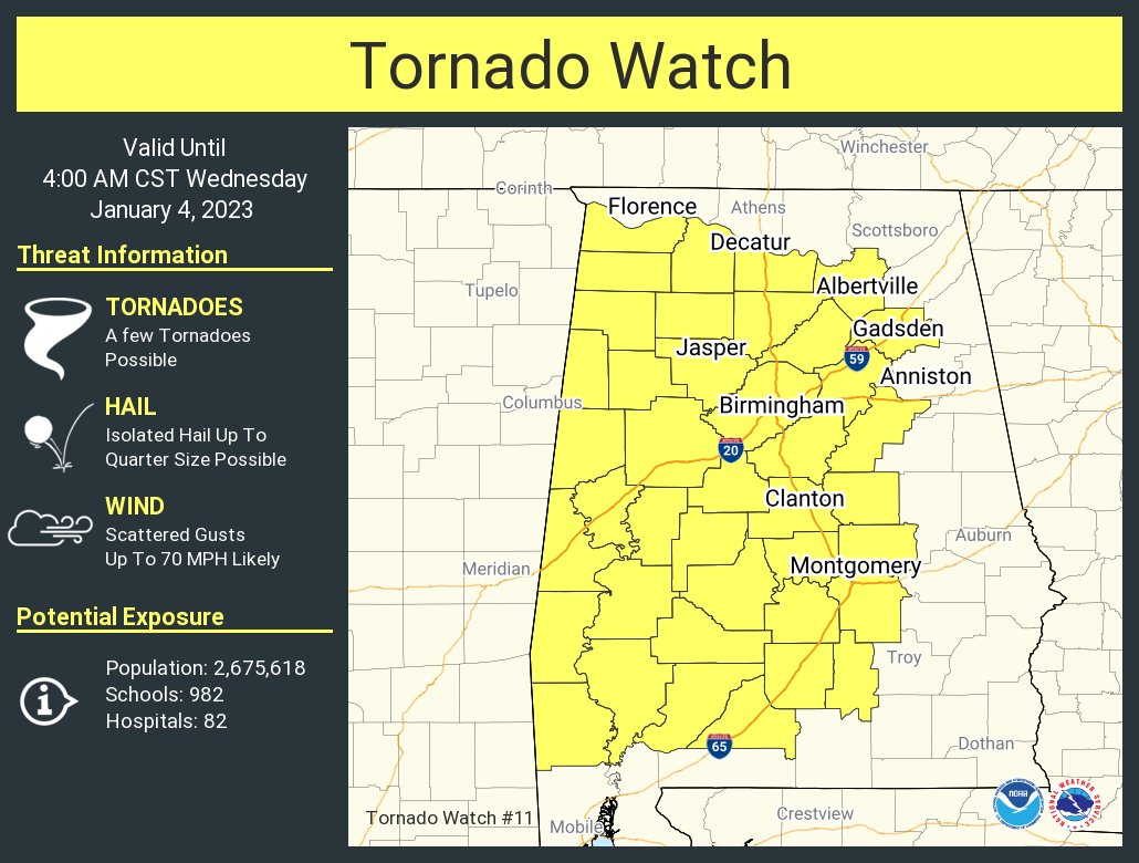
The Storm Prediction Center, along with NWS Huntsville and NWS Birmingham, has issued a TORNADO WATCH effective immediately until 4 am Wednesday morning for the following counties:
Tennessee Valley — Colbert, Cullman, Franklin, Lawrence, Marshall, & Morgan.
Central Alabama — Autauga, Bibb, Blount, Chilton, Coosa, Dallas, Elmore, Etowah, Fayette, Greene, Hale, Jefferson, Lamar, Lowndes, Marengo, Marion, Montgomery, Perry, Pickens, Shelby, St. Clair, Sumter, Talladega, Tuscaloosa, Walker, & Winston.
URGENT – IMMEDIATE BROADCAST REQUESTED
Tornado Watch Number 11
NWS Storm Prediction Center Norman OK
1005 PM CST Tue Jan 3 2023
The NWS Storm Prediction Center has issued a
* Tornado Watch for portions of
Much of western and central Alabama
* Effective this Tuesday night and Wednesday morning from 1005 PM
until 400 AM CST.
* Primary threats include…
A few tornadoes possible
Scattered damaging wind gusts to 70 mph likely
Isolated large hail events to 1 inch in diameter possible
SUMMARY… Broken bands of supercells in Mississippi will spread
northeastward into Alabama through the overnight hours, with some
increase in storm coverage expected. The storm environment will
support the potential for a few tornadoes, as well as damaging winds
of 60-70 mph and isolated large hail near 1 inch in diameter.
PRECAUTIONARY/PREPAREDNESS ACTIONS…
REMEMBER…A Tornado Watch means conditions are favorable for
tornadoes and severe thunderstorms in and close to the watch
area. Persons in these areas should be on the lookout for
threatening weather conditions and listen for later statements
and possible warnings.
Category: Alabama's Weather, ALL POSTS, Severe Weather
About the Author (Author Profile)
Scott Martin is an operational meteorologist, professional graphic artist, musician, husband, and father. Not only is Scott a member of the National Weather Association, but he is also the Central Alabama Chapter of the NWA president. Scott is also the co-founder of Racecast Weather, which provides forecasts for many racing series across the USA. He also supplies forecasts for the BassMaster Elite Series events including the BassMaster Classic.Subscribe
If you enjoyed this article, subscribe to receive more just like it.


