Sunday Weather Briefing: Wet Weather Ahead
It’s hard to believe that we are nearly done with January, but not before more rain falls into a month that has been wetter than normal for many parts of Central Alabama. Not all parts, and certainly not northwestern and northern Alabama, where things have been drier than normal over the past 30 days. Parts of the Tennessee Valley are between 1 and 2 inches below normal. But there is a chance that all of the area could be above normal by the time midnight Tuesday night rolls around. Let’s see how that might happen and what the rest of the next two weeks look like.
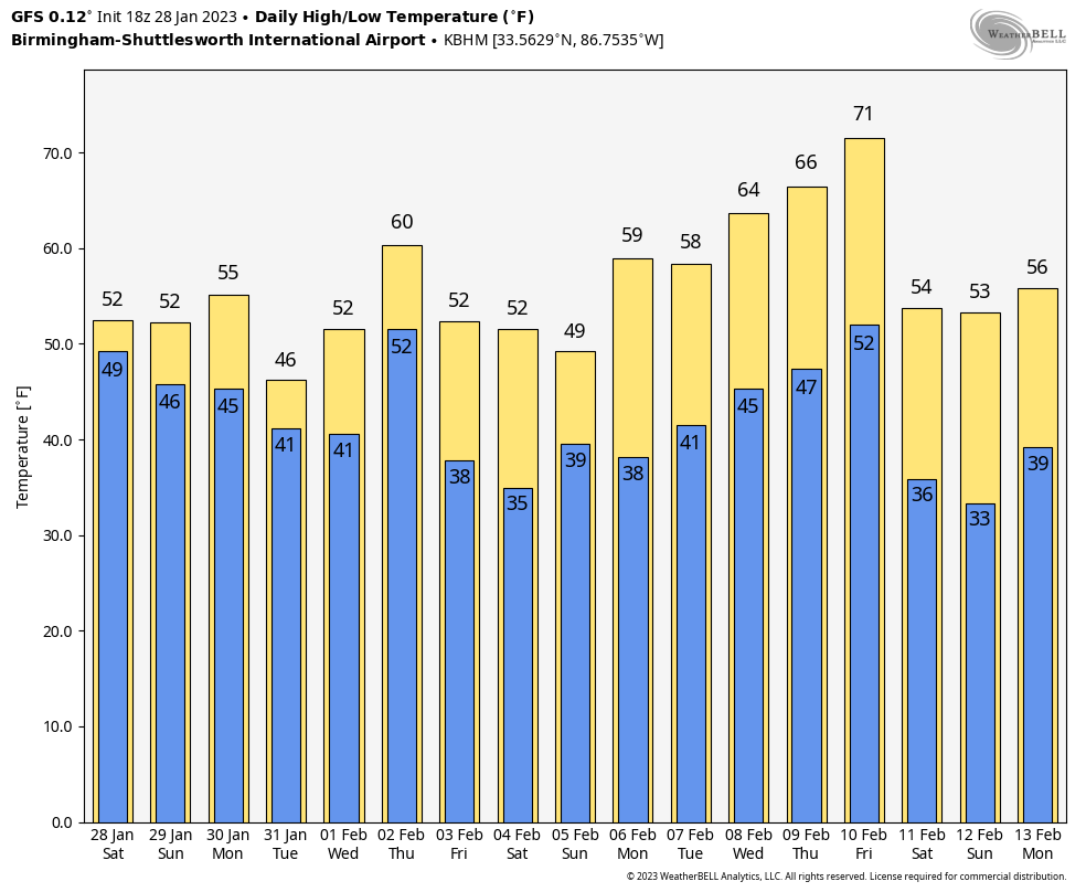
SPELLS OF RAIN: One of the forecasters at the National Weather Service in Birmingham referred to what we can expect this week as “spells” of rain. Pretty appropriate I would say, as it looks like we are going to deal with a few spells of rain in the days ahead.
WET SPELL #1: A band of rain is pushing slowly southeastward across Alabama today. It will be with us into the late hours tonight. And even after that, scattered showers will persist across much of the state through much of tomorrow. The heaviest rain will occur late this afternoon and this evening over South Alabama. There will be some thunder over South Alabama this afternoon and tonight, and there could even be a couple of severe thunderstorms in coastal sections. Noon to about 7 p.m. this evening is the peak threat period. Tornadoes aren’t out of the question, but damaging winds look like the primary issue. Sunday highs will be in the 50s North and 60s South. Most everyone is in the 40s overnight and 60s will return to the entire area tomorrow as clouds think just a tad, although most areas remain mostly cloudy. North and Central average rainfall will be around .60”. South Alabama will see much more.
WET SPELL #2: The next rain event will already be underway by Monday evening. Wintry precipitation will be possible over northeastern Arkansas and western Tennessee by late evening. Light rain will affect North and Central Alabama on Tuesday. Highs will generally be in the 50s. Average rainfall will be light, less than one-quarter of an inch.
SPELL #3: This event will be heavier and of much longer duration, lasting into Thursday. The northern half of Alabama will receive 1-2 inches, southern Alabama less, although South Alabama won’t clear out til later on Friday.
A DRY SPELL: North and Central Alabama will enjoy a reprieve from the rain Friday night and Saturday and part of Sunday.
WET SPELL #4: BY late Sunday, a significant surface low will be getting its act together over the northern Gulf south of Louisiana. A large shield of rain will be in progress by Sunday afternoon across much of Louisiana, southern Mississippi, and southwestern Alabama. That rain event will wind down on the following Monday.
VOODOO TERRITORY: The week two period looks like it will be dominated by high pressure and dry weather. There is a severe weather look though by that following weekend as temperatures soar toward 70 by that Thursday
BEACHCAST: Showers and a big part of the forecast along the beautiful beaches of Alabama and Northwest Florida this week. Every day won’t be a washout, but rain chances will be high. Temperatures will be mild, with highs in the 70s until Friday, when 60s will take over for the weekend. Lows will be in the 50s and 60s. Water temperatures are in the middle 50s. A high rip current risk will exist starting tonight through Monday night.
Click here to see the Beach Forecast Center page.
ADVERTISE WITH US: Deliver your message to a highly engaged audience by advertising on the AlabamaWX.com website. We have a lot of big plans for this year. Don’t miss out! We can customize a creative, flexible, and affordable package that will suit your organization’s needs. Contact me, Bill Murray, at (205) 687-0782 and let’s talk.
WEATHERBRAINS: This week, the panel had a deep discussion about the January 12th tornado outbreak in Alabama. Check out the show at www.WeatherBrains.com. You can also subscribe on iTunes. You can watch the show live on our new YouTube channel for the show.You will be able to see the show on the James Spann 24×7 weather channel on cable or directly over the air on the dot 2 feed.
ON THIS DATE IN 2012: A brushfire combined with dense fog to reduce visibilities along I-75 near Gainesville, FL, causing a series of crashes along the interstate. Eleven people were killed and eighteen others were hospitalized. The interstate had been closed for a time but reopened before the crashes. The heat from some of the resulting fires actually burned away the asphalt. A total of sixty-two acres were burned by the fire. Follow my weather history tweets on Twitter. I am @wxhistorian at Twitter.com.
Category: Alabama's Weather, ALL POSTS
About the Author (Author Profile)
Bill Murray is the President of The Weather Factory. He is the site's official weather historian and a weekend forecaster. He also anchors the site's severe weather coverage. Bill Murray is the proud holder of National Weather Association Digital Seal #0001 @wxhistorianSubscribe
If you enjoyed this article, subscribe to receive more just like it.


