Midday Nowcast: Clouds and Showers
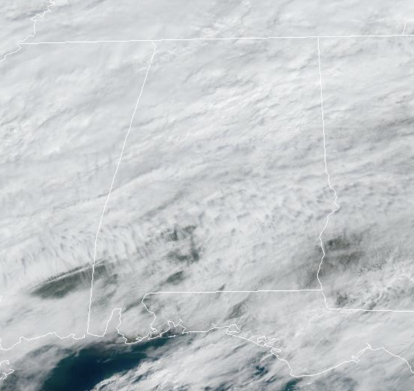
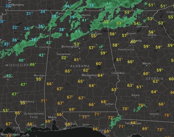
Showers have been ongoing this morning across North Alabama along the cold front which is slowly sinking south through the state. Showers will remain in the forecast today and tomorrow along with mainly cloudy conditions. Temperatures today across the state range from the 70s over the southern half of the state, while 30s are common north of the front in Northwest Alabama. Much of North/Central Alabama is seeing temperatures in the 50s and 60s this afternoon. Tomorrow as the front pushes farther south, 40s and 50s are likely to more common for North/Central Alabama, while 70s continue across the southern third of Alabama.
ICE, ICE BABY: An ice storm warning remains in effect for parts of West Tennessee (including Memphis), extreme Northwest Mississippi, and Arkansas where freezing rain will bring ice accumulation and potential for major travel impact and power outages. It will be a very close fall for far North Alabama (communities near the Tennessee state line) tonight and tomorrow morning, where light rain will fall with temperatures in the 31-35 degree range. For now there are no advisories in effect for any parts of Alabama; if freezing rain develops warm soil temperatures should help to mitigate any big problems, but if you are driving in that area just know some patchy bridge icing can’t be ruled out and expect travel headaches.
WET THURSDAY: The main system lifts through the area on Thursday and that will bring a widespread, soaking rain to the state. Rain amounts of 1-2 inches are likely across North/Central Alabama. The air will be stable with temperatures in the 50s so no severe storms for most of the state, however, the SPC has introduced “marginal risk” (level 1/5) of severe thunderstorms Thursday for areas near the Gulf Coast… a few storms there could produce gusty winds, and there is a low end threat of a brief tornado or two as the air will be more unstable due to temperatures in the 70s.
FRIDAY AND THE WEEKEND: Dry air returns Friday with a clearing sky, and Saturday will feature sunshine in full supply. A disturbance will bring some clouds Sunday along with the chance of some light rain, but noting too heavy or widespread at this time. Temperatures over the weekend will be seasonable with highs in the 50s and lows in the 30s and 40s.
NEXT WEEK: Monday and Tuesday look rain-free, but rain and maybe some storms will return on Wednesday with a cold front. Drier air follows by Thursday and Friday. Seasonable temperatures next week with highs in the 50s and 60s, and lows mainly in the 40s.
BEACH FORECAST CENTER: Get the latest weather and rip current forecasts for the beaches from Fort Morgan to Panama City on our Beach Forecast Center page. There, you can select the forecast of the region that you are interested in visiting.
WORLD TEMPERATURE EXTREMES: Over the last 24 hours, the highest observation outside the U.S. was 108.0F at Onslow Airport, Australia. The lowest observation was -62.7F at Selagoncy, Russia.
CONTIGUOUS TEMPERATURE EXTREMES: Over the last 24 hours, the highest observation was 90F at Dundee, FL. The lowest observation was -55F at Peter Sinks, UT.
Category: Alabama's Weather, ALL POSTS
About the Author (Author Profile)
Macon, Georgia Television Chief Meteorologist, Birmingham native, and long time Contributor on AlabamaWX. Stormchaser. I did not choose Weather, it chose Me. College Football Fanatic. @Ryan_StinnetSubscribe
If you enjoyed this article, subscribe to receive more just like it.


