Midday Nowcast: Clouds and Warm Temperatures
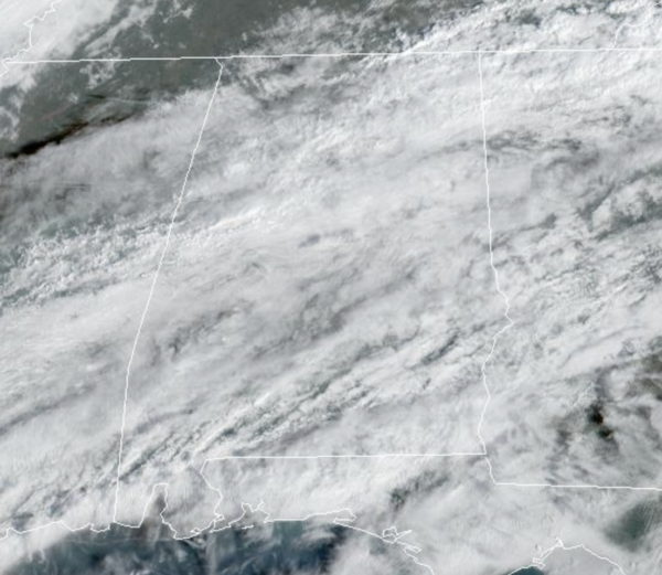
The strong upper-level ridge in place over the Gulf of Mexico continues to allow temperatures to be 15-25 degrees above average for this time of year. Highs again today in many locations are in the low 80s. We continue to deal with some gusty winds at times with more clouds than sun. We are also seeing some scattered rain showers on the radar today, due to the very warm and moist air mass in place across the state.These are mainly light, with an occasional quick downpour mixed in, but still most locations will remain dry.
ACROSS THE USA: Two powerful winter storms will bring widespread areas of wintry precipitation from coast to coast. Heavy snow, significant icing, and blizzard conditions are possible in portions of the Upper Midwest eastward into the Northeast. Heavy rain, snow, wind, and cold temperatures will affect much of California through the end of the week. Dangerous travel conditions are expected.
TOMORROW AND THE WEEKEND: A weak cold front will move into the state, and tomorrow will be a bit cooler with highs in the 60s. Scattered rain showers will continue to be on the radar tomorrow as the surface front stalls out. For the weekend, showers will remain in the forecast Saturday across the northern half of Alabama with a mostly cloudy sky. Sunday looks mainly dry with more clouds than sun; highs both days will be in the in the 70s.
NEXT WEEK: A cold front will bring a chance of showers, and possibly a thunderstorm Monday, but severe storms are not expected thanks to the upper ridge, and limited instability. Dry weather is likely Tuesday through Thursday, followed by a chance of rain and storms Friday. Highs through the week will be mostly in the 70s.
BEACH FORECAST CENTER: Get the latest weather and rip current forecasts for the beaches from Fort Morgan to Panama City on our Beach Forecast Center page. There, you can select the forecast of the region that you are interested in visiting.
WORLD TEMPERATURE EXTREMES: Over the last 24 hours, the highest observation outside the U.S. was 113.4F at Nullarbor, Australia. The lowest observation was -68.4F at Delyankir, Russia.
CONTIGUOUS TEMPERATURE EXTREMES: Over the last 24 hours, the highest observation was 101F at Falcon Lake, TX. The lowest observation was -27F at Seagull Lake, MN.
WEATHER ON THIS DATE IN 1802: A great snowstorm raged along the New England coast producing 48 inches of snow north of Boston. Three large ships from Salem were wrecked along Cape Cod.
Category: Alabama's Weather, ALL POSTS
About the Author (Author Profile)
Macon, Georgia Television Chief Meteorologist, Birmingham native, and long time Contributor on AlabamaWX. Stormchaser. I did not choose Weather, it chose Me. College Football Fanatic. @Ryan_StinnetSubscribe
If you enjoyed this article, subscribe to receive more just like it.


