Sunday Weather Briefing Video: March Set to Roar In Like a Lion
Alabama’s Sales Tax Holiday continues today. It is an excellent chance for you to pick up many of the items required to fill your family’s emergency kit, all tax-free! Items like flashlights, batteries duct tape, fire extinguishers, and much more. Check it out.
BATTLE OF THE AIRMASSES: We have been riding a temperature seesaw across Central Alabama as low pressure to the north has been trying to undercut the powerful subtropical high-pressure system over the Deep South. It looks like the high will win out through Monday when a low-pressure system and cold front will bring cooler temperatures into the region.
MOSTLY GLOOMY SATURDAY: Clouds were thick across most of the area yesterday. A few light showers did decorate regional radars through the day and into the evening, but they weren’t of much consequence. The sun did make an appearance by late morning across portions of South Central Alabama. After lows in the 50s over the northern half of the state, with 60s over the South, afternoon readings described a big range across the state, with Tennessee Valley locations struggling to surpass 60F, while South Alabama was sweating with highs in the lower 80s. Mobile and Montgomery tied their record highs for the date with 84F. Central Alabama locations were between 69-78F. Overnight lows were in the 50s for most. Areas from Montgomery southward were in the 60s. A little patchy fog developed in spots, and it will linger into Sunday morning.
SPRINGLIKE FOR YOUR SUNDAY: Clouds should gradually be thinning during the daylight hours on Sunday, which will allow the mercury to warm a bit more than yesterday. High temperatures will climb into the 70s overall but extreme northeast Alabama, where upper 60s will prevail.
STRONG SYSTEMS UPCOMING: Several strong storm systems are going to parade across North America over the next two weeks, using the energy derived from the contrast between cold and heat as its energy course. The powerful system that is battering California will eject out into the Rockies and Plains over the next 24 hours and then race toward the Ohio Valley on Monday. This is going to set up the potential for a severe weather outbreak today over the Plains states.
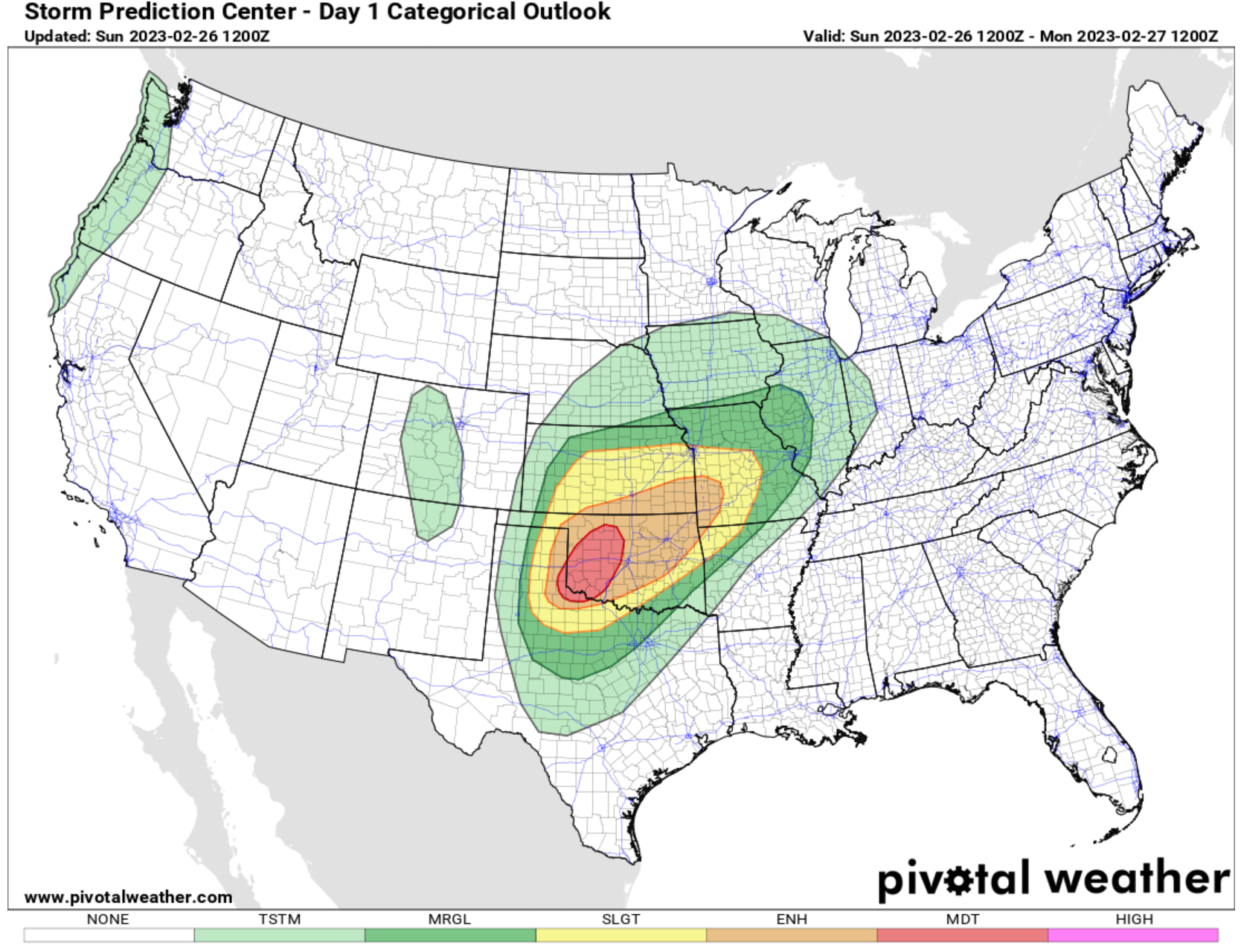
SEVERE WEATHER THREATS: Severe weather is a strong possibility today, with the SPC posting a Moderate Risk (level 4 out of 5) for western Oklahoma, with a surrounding Enhanced Risk (3/5) across the rest of Oklahoma back into the Texas Panhandle. A Slight Risk extends up into Kansas and Missouri, A few tornadoes are possible before the thunderstorms congeal into a powerful squall line when wind damage will take over as the primary threat. The threat tomorrow will move to the Ohio Valley, well to the north of Alabama. But we will have to watch the system for Thursday and Friday. It has a severe weather look for us then. More on that in a minute.
SYSTEM ONE: By Monday morning, we will be tracking a strong surface low over southern Iowa. A ragtag band of showers and some thunder will be pushing southeastward into Alabama during the day on Monday. It will become very windy with the vigorous storm system passing to our northwest. Winds could gust to nearly 40 mph! The threat for severe weather looks very small, but with highs will be in the 70s areawide, with a few 80s sprinkled across South Alabama, and dewpoints in the 60s, there will be some instability. Some slightly cooler air will filter into Alabama Monday night behind a weak cold front, with lows in the 50s mostly, along with a few upper 40s.
TUESDAY/WEDNESDAY: Both days look mostly dry, although a few showers and storms could show up Wednesday afternoon and evening as the airmass moistens again across Alabama and the South ahead of our next storm system. Rain and storms will be increasing Wednesday night, lasting into Thursday morning. It will become windy as well. Some of these storms could be strong to severe. Highs on both days will be in the 70s mostly with 80s down South. Overnight lows on both mornings will be in the 50s.
END OF THE WEEK: By Thursday morning, another powerful upper-level disturbance will be over New Mexico, swinging toward Texas. Rain and storms will still be in progress across Alabama. Those windy conditions will continue during a balmy morning. Highs on Thursday will be in the 70s across North and Central Alabama. Meanwhile, we will be watching things unfold to the west of Alabama where a very unstable and sheared airmass will take shape by Thursday afternoon over the Arklatex. A strong line of storms will advance into Mississippi Thursday night and approach western Alabama after midnight. Enough instability will be in place over western sections of Alabama for severe storms. While it looks like it may take the form of a severe squall line, there is enough uncertainty that tornadoes can’t be ruled out during the early morning hours. A large shield of rain will advance across the state Friday during the day. Highs will top out in the 60s.
THE WEEKEND: Friday and Saturday will be dry and cool with lows on both mornings in the 40s and lows in the upper 50s to lower 60s.
NEXT RAIN CHANCES: It looks like our next rain chances will be on Tuesday and Wednesday the 7th and 8th of March. That week two period, otherwise known as Voodooland, will feature mild conditions with highs in the 70s and morning lows warming through the 40s and 50s.
BEACHCAST: Not a bad week to be at the beautiful beaches of Alabama and Northwest Florida. Things should be warm and dry until late Thursday, when a few scattered showers may appear. Highs will be in the upper 70s through Thursday, with lower 70s returning on Friday and 60s on Saturday and Sunday. Lows will be in the 60s until the weekend when they will fall back into the 50s and even 40s. water temperatures are beginning to rise. They are in the middle 60s now. There will be a high rip current risk through midweek, so stay out of the water when the red flags are flying.
Click here to see the Beach Forecast Center page.
NATIONALLY: Snow continues across parts of the West today, and more is expected. A Winter Storm Watch is in effect for the Sierras of California, where 3-5 feet of snow is expected above 7,000 feet with 1-2 feet at the level of Lake Tahoe.
DANCING WITH THE STATS: Several charming southern cities established new record highs for February 21st on Friday. Mobile topped out at 83F, breaking their old record of 81F. Savannah and Charleston tied their record highs for the date with 86F and 81F respectively. Not to be left out of the charming category, or the record side either, Apalachicola recorded a high of 81F, tying their record for the date. On the other side of the scale (and country), Lander WY established a new record low for the date with -21F.
ADVERTISE WITH US: Deliver your message to a highly engaged audience by advertising on the AlabamaWX.com website. We have a lot of big plans for this year. Don’t miss out! We can customize a creative, flexible, and affordable package that will suit your organization’s needs. Contact me, Bill Murray, at (205) 687-0782 and let’s talk.
WEATHERBRAINS: This week, the panel will entertain Dr. Scott Rudiosky, an expert on the Global Lightning Mapper. Check out the show at www.WeatherBrains.com. You can also subscribe on iTunes. You can watch the show live on our new YouTube channel for the show. You will be able to see the show on the James Spann 24×7 weather channel on cable or directly over the air on the dot 2 feed.
ON THIS DATE IN 2012: The 54th running of the Daytona 500 is remembered as the first to be postponed by rain. A persistent, moist southwesterly flow parallel to a stalled frontal system over the northern Gulf Coast produced a day of rain at the Speedway. Less than an inch of rain fell, but it was enough to force the race to push back to Monday when the forecast wasn’t any better. The race was finally run on Monday night and Matt Kenseth took the checkered flag under the lights. Follow my weather history tweets on Twitter. I am @wxhistorian at Twitter.com.
Category: Alabama's Weather, ALL POSTS, Severe Weather
About the Author (Author Profile)
Bill Murray is the President of The Weather Factory. He is the site's official weather historian and a weekend forecaster. He also anchors the site's severe weather coverage. Bill Murray is the proud holder of National Weather Association Digital Seal #0001 @wxhistorianSubscribe
If you enjoyed this article, subscribe to receive more just like it.


